
In the new proposed City Development plan in Section 4 Sustainable Mobility and Transportation, it seems to be favouring less on street parking which ideally is a good thing, I myself use a bicycle...
Chapter 4: Sustainable Mobility and Transportation
Closed28 Feb, 2022, 9:00am - 13 Apr, 2022, 11:59pm
4.1 Context
Travel demands for Galway City are increasing in conjunction with population growth and will continue to do so over the lifetime of this Plan. Improvements to the transportation network will be essential if Galway is to become a sustainable, compact and connected city in line with national and regional policy direction. At a regional level, Galway is the only identified city of scale in the Northern-Western Region and is also the key driver of the economy for the region. The city transport network is pivotal in serving the inter-urban and inter-regional connectivity for its broad catchment area. The network also supports a high volume of commuters into the city on an average weekday numbering in excess of 30,000 vehicles (15,000 each way) entering and leaving the city. In light of this volume of traffic and the expected additional growth, which will without intervention perpetuate the current unsustainable patterns, there is an urgency to re-think the way we move to help ease congestion in and around the city and to reduce carbon emission levels.
The Galway Transport Strategy (GTS) is the transport plan that aims to establish a more sustainable approach to address current and future transport requirements and underpins the future growth of the city. The policy approach in this plan supports the measures in the GTS and includes for the strengthening of links between land use and transportation planning. It also focuses on reducing car dependency and supports a transition towards increased use of more sustainable active modes and public transport. This will require investment in walking and cycling, an improved and more accessible public transport system supported by low emission infrastructure, to address transport challenges in the city and accord with national, regional and local policies. Enhanced walking and cycling facilities will be promoted through greater permeability and increased networks, making these travel modes more attractive, accessible, safe, and healthier travel options. A transition to use of these active modes and public transport will also have significant potential to improve air quality, the urban environment, the economic performance of the city and the overall quality of life in the city.
National and Regional Policy
The National Planning Framework (NPF) identifies that sustainable mobility and compact development are necessary to achieve the ambitious growth targets provided for in the NPF. In this regard land use and spatial planning sets out the overarching policy direction which emphasises the importance of aligning land use and transportation to achieve more compact development. This will encourage more sustainable patterns of travel in tandem with the targets to transition to a low carbon and climate resilient society. The NPF specifically addresses the legacy of growth challenges for Galway in transport, mobility and urban quality. It also acknowledges that the Galway Metropolitan Area shares many of these challenges arising from growth and economic success with much larger cities. The challenge for Galway is that it needs to accommodate a greater proportion of the growth it generates within the metropolitan boundaries.
The NPF is supported by the national investment strategy of the National Development Plan (NDP) and the Regional Spatial and Economic Strategy (RSES) for the Northern and Western Regional Assembly area (NWRA). The NDP sets out investment priorities to deliver on the goals of the NPF. The NDP recognises Galway City’s key role as a designated Regional City and driver for investment and identifies key infrastructure projects which can support and enhance Galway’s role. To support this role, the NDP identifies key investment for a number of projects, including Transport Projects.
The recent review of the NDP, 2021-2030 endorses a cleaner, greener, connected Ireland with a pledge to cut emissions in half by 2030. This plan has committed the biggest investment in transport in the history of the state with 35 billion over the decade provided in an effort to transform how we travel. This plan provides for a 2:1 spending ratio on sustainable transport measures, meaning that for every euro invested in new road infrastructure, twice as much will be invested in new public transport and in walking and cycling infrastructure.
Sustainable Mobility
The existing sectoral policy documents which were published in 2009 - Smarter Travel - A Sustainable Transport Future 2009-2020 and the National Cycle Policy Framework have been the overarching policy guiding smarter and sustainable transport development in Ireland. They aimed at reducing private car use, ensuring alternatives to the private car were available and improved fuel efficiency as well as initiatives to create a culture of cycling and walking in Ireland. These national policy documents which promoted sustainable travel modes are in the process of being succeeded by a new Sustainable Mobility Policy Framework.
The review of these policies aligns with the policy in the NPF and in particular supports the National Strategic Objectives (NSOs) which is shifting the momentum of transport policy to support climate action and sustainable mobility. The aim is to develop a new policy framework that better supports sustainable mobility and adopts a more people centric approach, reviewing all aspects of Active Travel and Public Transport Policy. The draft policy is centred on three overarching principles. The first of these is Safe and Green Mobility, which will set out an ambitious and comprehensive set of actions for the decarbonisation of public transport. The second is People Focused Mobility, which focuses on how to make sustainable mobility options accessible to everyone, particularly people with reduced mobility. The third principle is Better Integrated Mobility, which looks at better integrated sustainable transport and land-use planning as well as examining smart transport solutions.
Climate Action
The National Climate Action Plan (2019) indicates that transport accounts for almost one fifth of Ireland’s greenhouse gas emissions. Commitments to reduce Ireland’s greenhouse gas emissions by 51% over this decade and to achieve climate neutrality by 2050 were set out in the Programme for Government and in climate legislation. The associated actions that enable the achievement of these targets will be set out in an updated Climate Action Plan. There is significant potential for the Council to contribute to meet reduced emission requirements through modal shifts to walking, cycling and public transport, supporting the build-out of the electric vehicle (EV) charging network, conversion of the public fleet to EVs, and use of biofuels, which are some of the main measures being promoted by the Action Plan to achieve these targets in the transport sector. Decarbonisation of road transport will be critical in achieving the ambitious emission reduction target of 7 per cent per annum over the lifetime of this plan.
RSES
The RSES for the Northern and Western region was adopted in January 2020 and also includes the Metropolitan Area Strategic Plan (MASP) for Galway. This MASP sets a co-ordinated framework for planning and investment in Galway City and its environs. The RSES recognises the strategic importance of Galway City being a connected city and a strategic link for the region. The social, economic and environmental wellbeing of Galway City and the Northern and Western Region is dependent on transport and infrastructure investment in order to improve accessibility and connectivity to the County and areas beyond. The RSES identifies transport investment priorities in accordance with the NDP investment commitments to bring a number of key enabling schemes to delivery in the Region by 2027 and includes the N6 Galway City Ring Road (N6 GCRR). The RSES also highlights the importance of Galway Port as a Port of regional significance, the Western Rail Corridor as a rail project with strategic importance and supports the development of a Strategy for the electrification of the rail network. It endorses greenway and blueway projects as a priority across the region and highlights the importance of walking and cycling in facilitating a modal shift to more sustainable transport options, promoting healthier lifestyles, better traffic management and assisting in mitigating climate change.
MASP
The Galway MASP recommends the integration of land use and transport planning and performs a critical role in enabling the requirements of an expanded Metropolitan Area to be met in a sustainable manner. The projected population growth identified for Galway MASP will bring challenges for the provision of supporting infrastructure and services, including for transport. This plan endorses the implementation of the measures contained in the Galway Transport Strategy (GTS) with the key transportation components for the MASP considered central to addressing the traffic congestion and Green House Gas (GHG) emissions to achieve change. The main transportation components in the MASP includes the N6 GCCR which is stated as a key priority for the Metropolitan Area that will support the economic and social development of the region and improve connectivity and accessibility to the city and areas west of the city. Other significant transportation components include the development of public bus transport, cycle networks and walking improvements for pedestrians, focusing on connectivity and permeability.
Galway Transport Strategy (GTS)
The GTS, 2016-2036 represented a partnership approach between Galway City Council, the County Council, the National Transport Authority (NTA) and Transport Infrastructure Ireland (TII). The City Council adopted this long-term transport strategy with the purpose of developing a strategy for Galway City and Environs. This is the Strategy for which all transport investment is coming from and will be informed.
The approach of the GTS is to deliver significant improvements to active travel and to deliver a high quality public transport network for Galway to support the city’s growth by encouraging the use of other sustainable modes of transport, and facilitate the efficient movement of private vehicles and freight. The Strategy identifies key transport proposals and interventions to provide a framework for phased implementation of the plan-led approach to transportation to facilitate Galway with an opportunity to grow both physically and economically. The GTS also includes for traffic management measures, giving priority to walking, cycling and bus movements, modifications to the traffic network, management of parking activities and heavy goods vehicles, improvements to the public realm and use of ‘smarter mobility’.
The GTS addresses current and future transport requirements and sets out an overview of the proposed actions and measures for implementation, covering infrastructural, operational and policy elements to address the current transport inefficiencies. The GTS is recognised within the NPF as key to achieving the target of 50% population growth within the Metropolitan Area by 2040 in facilitating the delivery of compact growth and sustainable transport in the Galway MASP area.
The core of the strategy is built around a ‘Cross-City Link,’ which provides a safe, coherent and attractive route through the city centre restricted to public transport, pedestrians, cyclists, and some local access. The strategy also supports a defined ‘City Centre Access Network’ for private car journeys and HGVs that require access to the city centre to reduce congestion, and the proposed N6 Galway City Ring Road (N6 GCCR) which will re-route journeys, removing non-essential motorised traffic from the city centre. The planned N6 Galway City Ring Road (N6 GCRR) is a strategic project that is also identified in the NPF, NDP, RSES and MASP. This orbital route is a key project in the transport strategy for the city that will support journeys that are not always convenient by non-car modes. This project has been approved with conditions and modifications by An Bord Pleanála. Other transport measures will also be progressed that will enable an efficient and reliable public transport service to provide access into and through the city centre creating an enhanced environment for walking and cycling.
The delivery of the GTS is currently underway with a focus on providing infrastructure to support walking, cycling and public transport to meet the current needs of the city. Design work has commenced on the bus routes as part of the BusConnects with an application for consent for the Cross City Link expected in early 2022. Implementation of the Galway Cycle Network including greenways, primary, secondary and feeder routes is also at design stage. URDF funding received for Transport Connectivity Projects in 2021, included for the Galway City Cycle Network and the Clifden Railway and Pedestrian Bridge, which on implementation of these projects will achieve the overall aim of delivering a safe, cohesive city cycle network and pedestrian facilities as prescribed in the GTS.
This Draft Development Plan will continue to progress a sustainable transport solution for the city and identify how it is intended to deliver and build upon the work of the GTS, while continuing to support the measures set out in the GTS. A planned evidenced based review of the GTS is due to be carried out in 2022 in conjunction with Galway County Council and the National Transport Authority (NTA), which will consider all transport modes including the feasibility of a light rail option and will not preclude the advancement of the Cross City Link route to planning consent stage.
The implementation of the GTS is being supported through service delivery plans funded predominately by the NTA and TII. While the implementation of various measures has made some improvements to the transport network, serious traffic congestion still prevails, impacting the quality of life, the economy of the city and the regional role of Galway. The GTS is in its fifth year of a 20-year plan and while still in its infancy, the projects and objectives in this plan remain relevant for Galway City over the lifetime of this plan, with various implementation timeframes set out as short, medium and long term for the projects. Implementation to achieve the measures set out in the GTS will be ongoing to improve transport conditions and journey choices for all in Galway.
|
Policy 4.1 General |
|
|
|
|
|
|
|
|
|
|
|
|
|
4.2 Land Use and Transportation
The integration of land use and transportation is essential in creating a sustainable city. The alignment of settlement and land use patterns with an integrated transportation strategy can provide opportunities to reduce car dependency and allow for greater investment in alternative means of travel including public transport, walking and cycling. It also delivers considerable benefits in terms of reducing congestion, reduced greenhouse gas emissions, enhanced well-being and has benefits for the public realm.
The consolidation of development allows for the effective provision of services enabling more sustainable patterns of travel. Embedded in this approach is the need for sustainable densities in all developments and emphasis on regeneration and brownfield sites. Adopting these principles will guide strategic investment decisions and align with national targets on climate action.
Historically, residential development in the city suburbs, similar to national development trends have traditionally consisted of lower density development and separation of employment areas relative to residential areas, which has led to a prevailing pattern of car-dominated movement in and around the city. The current focus is to rethink this pattern and create compact cities and focus more on integrating land use and transportation to offset these issues. These changes in tandem with improvements in active travel measures, such as walking and cycling and public transport are necessary to create positive changes. Creating opportunities for people to live and work in proximity to employment and services supported by a modern and efficient public transport network is fundamental to the success of Galway as a City, both in terms of a successful city of neighbourhoods and as the economic driver of the Region. This will also support the development of the ‘15-minute city’ concept included for in Chapter 3, allowing for the effective provision of services including public transport, employment, shops, community and education facilities to enable more sustainable patterns of travel and reduces overall travel demand.
Implementation of the GTS measures will support the integration of housing with transportation, fostering sustainable transportation patterns. The Core Strategy has been informed by the GTS and provides for a co-ordinated approach with investment and the delivery of essential infrastructure, services and community facilities. It is predicated on consolidation within the established settlements at appropriate densities and the prevailing associated policies in the City and County Environs.
The Strategy for the city supports NPF policy and promotes the three key regeneration sites - Ceannt Station, Inner Harbour, the Headford Road Regeneration area and other opportunity sites. The Ceannt Station and the Inner Harbour offer a sequential solution to the expansion of the city centre, linked with a transportation hub, reinforcing the prime role of the city centre in both the city and the Metropolitan Area and the wider region. The consolidation of existing residential areas and development of Ardaun LAP area to the east of the city utilising this approach will help to create future sustainable residential neighbourhoods, where the reliance on private transport is reduced and where services are provided locally, allowing access by walking and cycling. The alignment of land use and transportation is also supported in the Retail Strategy where a hierarchy of centres encourages easily accessible shopping and essential services.
At a local level, the preparation of plans including Local Area Plans and Masterplans provide a framework for mixed-use development in conjunction with a transport strategy and use of sustainable densities at locations adjacent to public transport routes. These plans will ensure that sustainable patterns of travel integrated with land use will be achieved.
|
Policy 4.2 Land Use and Transportation |
|
|
|
|
|
|
Modal Change
4.3 Public Transport
The GTS establishes that the transport framework needs to increase a shift from car based movements towards sustainable transport modes including public transport. This change will require a collaborative approach between all transport stakeholders including in particular the NTA, TII and transport providers. The Core Strategy creates an enabling policy context in the Plan to support the implementation of the measures in the GTS that will in conjunction with infrastructural investment and service provision provide for a high quality, accessible public transport system for the city and environs and good connectivity onwards.
The ambition is that through a combination of improved infrastructure, services and demand management measures that public transport and active modes will become more attractive and that a significant transfer from car use to these modes will occur in the city with the resultant benefits.
Bus Network - Local
The analysis undertaken as part of the GTS preparation considered all travel modes and a number of public transport scenarios and found that the city could be served more efficiently with high quality, high frequency bus services. The GTS proposes that bus frequencies will be increased to a 15 minute minimum during peak times and that bus stops will be within a 10 minute walk to where most people live. This involves the modification of bus routes to provide city- wide network coverage and connectivity to all parts of the city outside of the principal bus network.
The Cross-City Link is at the core of facilitating this local network. It is a public transport corridor operating cross-city from University Road to College Road, which will provide direct services for passengers wishing to enter the city from both the east and west and provides infrastructure for bus priority measures along this corridor. The objective of the Cross-City Link is to prioritise walking, cycling and public transport along its length. Car traffic, which does not have a specific destination in the city centre, will no longer travel into the medieval core of the city between restricted hours – making routes safer for walkers, cyclists, and mobility impaired, and creating space for public transport to move freely. The Cross-City Link will be instrumental in increasing public transport ridership and active travel uptake to achieve a modal shift from car to sustainable modes. This is essential for the sustainable growth of the city to facilitate the NPF growth projections. This corridor will connect homes with places of work, study, retail and recreation, with improved public transport journey times and reliability. Regional, national and private bus operators, emergency vehicles and small public service vehicles will also benefit from the Cross-City Link as it will provide enhanced access for these modes.
Using the existing bus route alignments as a starting point, a Cross-City Network was developed. This was based on linking the residential origins to the key destination locations. It reduces the number of bus services to five, making the network more legible for residents and visitors alike. These five proposed core bus routes are provided on the west, east and city centre as well as providing links to Bearna and Oranmore forming a Bus Network Corridor. All routes will serve major city centre attractions as well as linking all major destinations across the city and were designed to allow for cross-city interchange at key locations. Eyre Square has been identified as the main hub for bus transfers as well as bus/train and bus/coach at Ceannt Station and Fairgreen Station. Other key bus transfer hubs will be located at University Hospital and University Road/Cathedral.
The Cross City Network through the facilitation of new and existing bus routes offers a high-frequency bus service and has been retitled ‘BusConnects Galway’ as part of the NDP investment strategy and funding in the NTA programme for improvement of bus services across Ireland. The BusConnects Programme is a key part of Government policy to improve public transport and address climate change. Within the Galway City area, investment in bus infrastructure and services will be delivered through BusConnects and the relevant parts of the GTS. BusConnects Galway will deliver the rationalised network of five high-performing cross-city public transport routes and will form the ‘fixed spine’ of future public transport in Galway. BusConnects Galway is advancing the development of this network plan and associated infrastructure. It will comprise of next generation bus lanes, a bus shelter program, enhanced services, cashless fares and account-based ticketing. Under the BusConnects programme, the NTA intend to upgrade the existing bus fleet to transition to a fleet of low emission vehicles which will reduce both noise and air pollution.
Bus Network - Regional
Investment in the bus services will be focused on improving connectivity between regional settlements, including Galway City and Dublin, and enhancing the reliability and the level of service within and between key settlements. For regional and long distance bus and coach services, journey speed and reliability are the crucial issues. The import role that Galway City plays as a Regional City, providing connectivity to a large hinterland is recognised in the RSES and the plan supports the major national public transport initiative, NTA Connecting Ireland: Rural Mobility Plan, which will increase connectivity, particularly for those living outside the major cities.
Principal destinations of regional buses within the city will remain at Ceannt Station, Fairgreen Coach Station and Eyre Square. These will be complemented by controlled drop off and pick up locations in the city centre area following investigation in the context of the designated access routes into this area. The proposed Cross City Link efficiencies will also enable a much better regional service. This incudes for traffic restrictions along College Road as proposed in the GTS, which will significantly benefit connectivity for these regional services in conjunction with the priority measures proposed for the local bus network coming from the west, including the restrictions proposed on Salmon Weir Bridge. This regional service offers a valuable service for tourists, particularly for trips to and from Dublin and Shannon airport and to other tourist destination cities and towns. Coach parking for tourists will continue to be provided at Merchant’s Road and adjacent to Galway Cathedral.
The GTS sees the attraction of these services being enhanced further by the provision of interchanges between regional and local public transport at key locations in the city centre. The infrastructure proposals provided as part of the local bus network will enhance the regional services also, as the regional buses will be able to avail of the priority routes in the city and others, such as that proposed along the Dublin Road. Sufficient access to and from the termini in the city centre will also be required to be provided.
Public Transport Hubs
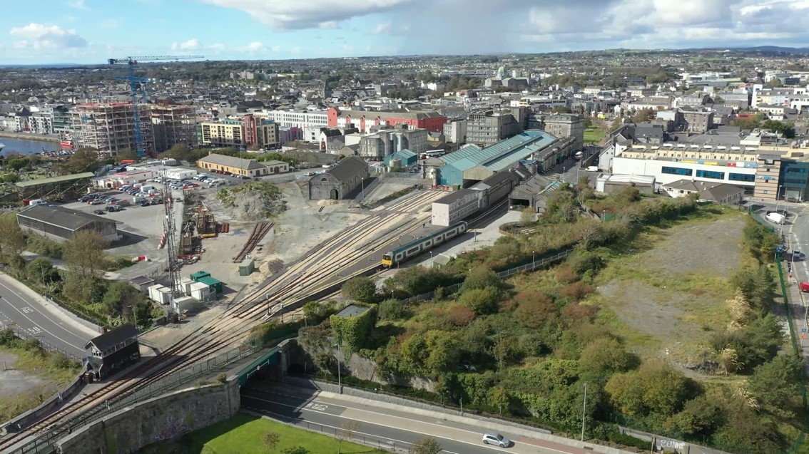
Ceannt Station is designated as a major transportation hub for both local and regional services. The redevelopment of the station recently secured funding under the Urban Regeneration and Development Fund (URDF) for Ceannt Quarter Regeneration. This will afford an opportunity to provide an integrated public transportation hub and multi-modal interchange capable of accommodating enhanced inter-urban, commuter and rail and bus services linked to other sustainable transport modes such as walking and cycling. Additional dedicated bus bays are anticipated as well as associated car parking and set down facilities dedicated for public transport users. Creating a more efficient, connected and attractive public transport system through the promotion of transportation hubs will provide opportunities to offer a complete journey.
A lower tier public transportation hub has been designated in the city near the Cathedral and future potential for additional hubs at key opportunity sites will be examined. These hubs will, in the future, have passenger facilities and will be important interchanges in the overall enhanced bus network of the city.
Rail
Galway City is a significant rail destination with direct intercity services to Dublin via Athlone and Limerick via Ennis. This plays a key role in offering sustainable travel alternatives for longer distance trips, providing improved interregional connectivity. It also provides a valuable commuter service to towns such as Ballinasloe, Athenry and Oranmore. The NDP includes for the Dublin–Galway rail lines to be subject to an examination to move to higher speeds leading to improved connectivity to regional cities through improved rail journey times. The potential for double tracking of the railway line from Galway City to Athlone with increased service stops between Athlone and Galway will improve commuter services. Although not included in measures as part of the GTS, the double tracking of the railway line from the city to Athenry, or a more limited accommodation of stopping bays is to be investigated for both passenger services and potential freight services from Galway Port. The facilitation of rail stops within the city which can support commuter services is also supported by the Council.
The County Draft Plan contains an objective to secure in co-operation with Iarnród Éireann (IE) improved rail infrastructure and services between Galway to Athlone. This project has attracted URDF funding and includes for a dual railway track and additional improvement works to include an additional platform and a passing loop at Garraune, Oranmore to ensure enhanced capacity and frequency of service. Such works to the line may also benefit the provision of a rail freight service from Galway Port and is a strategic project that would enhance accessibility and connectivity in the region.
The RSES also supports rail upgrades in the region and acknowledges that there is scope for further improvements to be made to existing rail services, connecting the Galway, Castlebar/Ballina and Sligo lines to Dublin and the rest of the Irish rail network. It also highlights the strategic importance of The Western Rail Corridor project and the contribution it would make in the realisation of the Atlantic Economic Corridor and the potential to link the economies of three major centres, Limerick, Galway and Sligo.
The designation of Ceannt Station as a major mutli-modal transportation hub for the city is a key objective. The redevelopment of Ceannt Station Quarter as a multimodal transport interchange facilitating better integration with other public transport modes will involve rail services expanding in frequency. The commencement of planned upgrades at Ceannt Station have been given recent NDP recognition over the lifetime of this NDP that upgrade works will take place at three of the four major regional rail termini, including Ceannt Station. These projects will be funded through both NSO 4: Sustainable Mobility and also the URDF, which will improve the passenger experience greatly in conjunction with adjoining public service provisions. The function of the station when coupled with the adjacent site of Ceannt Quarter will act as a collective hub for interchange between transport services in the city.
The GTS has made provision for periodic review to take account of emerging trends and any emergence of new development opportunities to reflect the change in circumstances of the evolving Galway transport network. The feasibility of a light rail option was included in the recent NDP, 2021-2030 with a commitment that this will be considered again as part of the review of the GTS, which will commence in 2022.
Park and Ride
The delivery of Park and Ride sites on the periphery of the city are key to the implementation of the GTS and modal shift. They will reduce the amount of commuter traffic entering the city and thus contribute to a reduction in traffic congestion and emission levels. A park and ride location analysis has been undertaken which will enable the identification of possible areas within Galway City and its environs where such facilities may be suitable and site identification is ongoing with the NTA.
Taxi Services
The role of taxi services is important in the overall development of an integrated transportation system. They will be facilitated at appropriate locations within the city and will be required to be accommodated within major developments. Where appropriate, they will be able to use bus priority infrastructure. Grant Schemes made available in 2021 are supporting the uptake of electric vehicles in the Small Public Service Vehicles (SPSVs) sector for taxis, hackneys, and limousines. This will help to initiate a transition to more sustainable vehicles in the public service in line with climate action requirements.
|
Policy 4.3 Public Transport |
|
|
|
|
|
|
|
|
|
|
4.4 Sustainable Mobility - Walk and Cycle
The GTS acknowledges that road improvements alone will not address traffic congestion issues and that investment in public transport, walking and cycling networks is also needed to improve traffic management and to encourage a shift to more sustainable modes. In this regard the GTS has prioritised both public transport and active modes as alternatives over private car usage for a range of trips within the city. Prioritising active travel measures and applying the DMURS (2019) design guidance and road user hierarchy will foster the development of a safer, more attractive, efficient, and connected transport system, while simultaneously encouraging healthier lifestyles and reducing transport emissions.
In Galway, the compact urban form of the city and the relatively flat topography allows for great potential for both walking and cycling for these modes to become the preferred choice of travel, in particular for short trips. The focus on these modes will support the concept of ‘15-minute city’ and allow for people to walk and cycle to key destinations in a direct and easy manner. With appropriate design, streets can also contribute to the creation of attractive, accessible and liveable neighbourhoods. This approach accords with the NPF and the need to pursue a compact growth policy supported by sustainability mobility measures including networked cycle and walking links and progressively reduce the dependency on car-based transport.
At regional level the RSES highlights the importance of walking and cycling in facilitating modal shift to more sustainable transport options and the benefits these modes can have for healthier lifestyles, better traffic management, enhanced community environments and in mitigating climate change. The strategy also identifies the potential economic and tourism opportunities that greenway and blueway projects have within the region. Within the MASP, the expansion of shared-bike schemes is promoted as a potential scheme that can make a positive contribution to connectivity and sustainable transport and mobility. The RSES acknowledges that places with extensive cycle infrastructure report higher levels of cycling and better health which in turn, creates economic value by appealing to a skilled workforce and attracting innovative companies.
Cycling
National policy gives guidance on measures to create a strong culture of walking and cycling. Promotion of these active modes in Smarter Travel – A New Transport Policy for Ireland 2009-2020 included for a series of actions that were aimed at ensuring that alternatives to the car are more widely available, mainly through a radically improved public transport service and through investment in cycling and walking. This policy was supplemented by the National Cycle Policy Framework (2009-2020), National Cycle Manual (2011), Design Manual for Urban Roads and Streets (2019) DMURS and Permeability Best Practice Guidelines (2015). The aim of the Sustainable Mobility Policy Framework that is in draft stage and will replace Smarter Travel and the National Cycle Policy Framework is to develop a new policy framework that better supports sustainable mobility – linking more people to more places, for more of their journeys and promoting increased use of active travel and public transport. These all promote cycling with the aim to maximize permeability and connectivity for cyclists, to create safe direct links to road networks and greenways and to provide additional cycle parking and infrastructure.
The delivery of the identified GTS Cycle Network is supported in the Core Strategy of the plan as it will play a critical element in developing a high quality, dedicated cycling network which is linked with existing and targeted settlement and employment areas. The Council is currently progressing the Cycle Network project through a dedicated project team, supported by the NTA Cycling Office and a range of funding streams including the NTA grant supports for sustainable transport measures and URDF funding. The network will give priority to cyclists, both for commuting and as a leisure activity and will when delivered encourage the uptake in cycling. The Cycle Network will also incorporate improvements to pedestrian facilities.
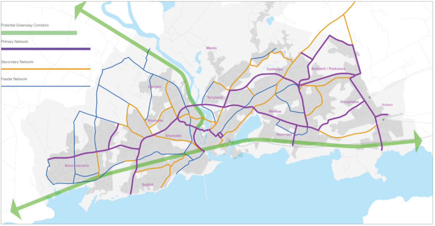
The GTS includes for a core, secondary and feeder Cycle Network which supports each other and reinforces connections across the city and environs. Where possible the proposed routes are fully segregated from motor traffic. In other locations, the network includes on road cycle lanes or sharing facilities with bus lanes. Where it is proposed to limit traffic, particularly in the city centre, the cycling environment will become much safer and more attractive. Chapter 5: Natural Heritage, Recreation and Amenity sets out the policies for the development of other greenway networks which identify key connections and linkages and have more of a recreational function, some with a capacity for walking only and some with potential for both walking and cycling.
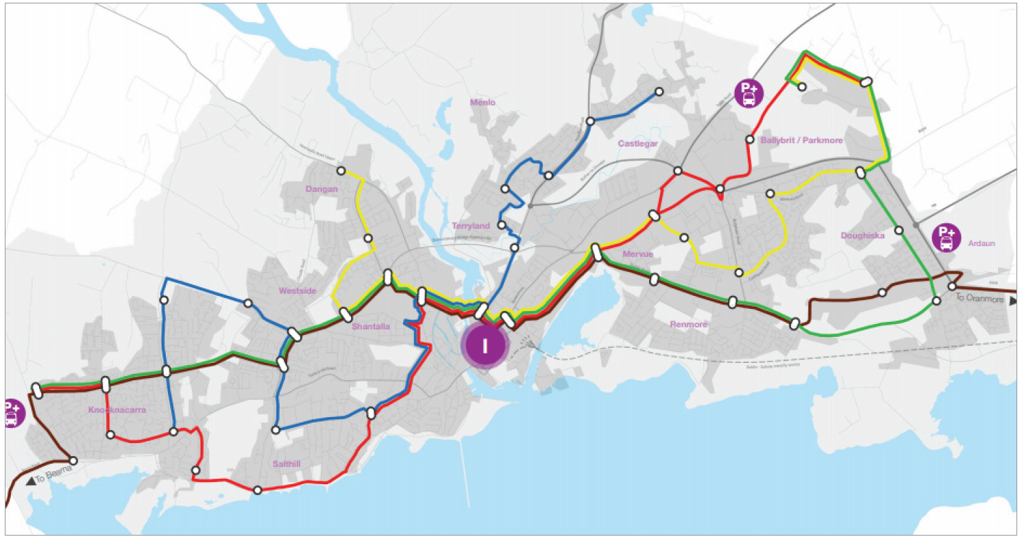
Fig. 4.2 GTS - Proposed Cycle Network, Source: Galway Transport Strategy 2016
The primary network focuses on the provision of segregated safe routes and connections from dedicated cycleways and footpaths to existing networks linking schools, workplaces and residential areas as alternatives to vehicular transport. These are designed to accommodate medium distance journeys. This level on the network also includes for two greenways providing connectivity for cyclists to and from nearby towns, one west to east linking Bearna and Oranmore and onwards, and one to the north crossing the River Corrib towards Moycullen. These align well with the national approach as defined in the Strategy for the Future Development of National and Regional Greenways (July 2018). The focus of this Strategy is on the delivery of Greenways that are of strategic significance on a regional or national level but which in turn can facilitate the development of linked and complementary local cycle networks that are being delivered outside of the strategy. The city greenways in the GTS can seamlessly link in with both the Connemara Greenway and the Galway to Dublin Greenway, both of which are at various stages of progression.
While these greenways may be designed specifically for the needs of cyclists in terms of gradients and surface, they are also intended for use by pedestrians, wheelchair users and children in buggies. Feasibility studies regarding the city greenway routes are currently being progressed in conjunction with the NTA and TII. As well as supporting active tourism, recreational opportunities and links to places of interest, the sections of greenways close to and within the city will also offer opportunities for use as commuter options for work and education. Funding opportunities for greenways are being provided from a number of sources including the Department of Transport, Tourism and Sport, TII Strategic Greenways, the NTA for active travel, and from an agreed pedestrian and cycling allocation from the BusConnects programme. The delivery of the GTS greenways will include for a co-ordinated approach between national agencies, Galway City Council and Galway County Council. Additional primary routes in the cycle network include cross-city routes to the north of the city, a city centre route and some key north to south links.
The secondary network provides for connections from residential areas and areas of employment to the primary network accessing key destinations. Feeder links have been identified on streets and roads that are highly constrained or suited to other modes, and need to cater for cyclists too.
Cycling and electric cycling combined have enormous potential to facilitate a high proportion of daily trips. To maximise this potential the appropriate infrastructure will be required in conjunction with coordinated policy provision as included for in the plan. The NDP 2021-30 recent commitment to €360 million a year for active travel measures will help to enable a significant modal shift to cycling and other sustainable modes with the corresponding benefits for climate action, health and air quality. This will also be facilitated through the NTA’s five year Walking and Cycling infrastructure Delivery Plan 2021-25.
Other supporting measures for cycling include schemes such as the Public Bike Share Scheme, “Coke Zero Bikes”, introduced across the city centre in 2014, which has been extended to 338 bike docking stations across 23 locations. This scheme will be progressed in partnership with the NTA and in the context of ongoing demand to facilitate enhancement of facilities and expansion of the current network to include for additional locations throughout the city.
Providing convenient cycle parking near bus stops and at key locations across the city, including at education locations, transport hubs, employment areas, commercial and community hubs and where appropriate in residential areas. This will be essential to the success of the network and needed to encourage the uptake in cycling. This was recognized in the recent 2021 NTA investment to support Parkmore Improvement works for cycling and infrastructure at this high employment area as identified in the Parkmore Area Strategic Transport Framework, 2019. Planning policy and development management standards will support the necessary integration of the cycling network and infrastructure into existing and planned developments. Where local area based transport solutions are required for areas of high employment, educational areas, or other high traffic areas, these will be supported also, subject to normal development management assessment.
Walking
The compact, walkable nature of the city, coupled with the high student population has contributed to the Galway sustaining a relatively high walking mode share of 23% of all trips taken. It is a key objective to increase on this level through enhancement of the pedestrian environment for all users. Measures in the GTS include the reduction of traffic volumes, improvement and prioritisation of pedestrian facilities to incorporate permeability and linking of walking networks in the city core. This will enable extended opportunities for pedestrianisation, improvement in the quality of the public realm, increased priority and safety for pedestrian facilities, in particular at junctions and crossings, and application of universal design principles to support the whole journey approach.
The benefits of pedestrian priority have been experienced already in the city centre in the pedestrianised zones, along the riverside walkway, canals and at Salthill. The GTS includes the need to improve on this and to give priority to the pedestrian network and the associated environment.
Safe access and improved permeability will also be secured through a number of new river crossings. These include the pedestrian and cycle bridge south of the Salmon Weir Bridge, due to commence construction in 2022.
This new bridge will facilitate an opportunity for a safer and higher quality crossing for the 9,000 pedestrians and cyclists who currently use the existing Salmon Weir Bridge. The proposed pedestrian and cycle bridge on the piers of the old Clifden Railway line from Woodquay to NUI Galway will link places of study, work, retail and recreation by sustainable modes of transport, bringing vibrancy and new areas of public realm.

The bridge, which has attracted URDF funding, will link in with the existing walking route along the River Corrib and ultimately the Connemara Greenway and also play a key role in connectivity in the GTS cycle network. In addition to the GTS measures, there is also an objective in the City Plan for a new bridge crossing linking Newtownsmyth and Gaol Road, which can contribute to the regeneration of Nun’s Island.
At Wolfe Tone Bridge, a cantilevered pedestrian bridge crossing is currently at design stage in order to provide safer and improved pedestrian crossing facilities adjacent to the existing bridge.
The implementation of the Public Realm Strategy (PRS) (2019-2040) complements many measures in the GTS. This Strategy provides a vision of place, design guidance and outlines project proposals to improve Galway's streets and public spaces. It identifies a number of opportunities to create usable spaces out of existing highway and parking areas including at Woodquay, Galway Cathedral, Eyre Square North and at the Small Crane, which could be transformed to deliver a better pedestrian experience and high quality public realm. It also includes proposals to rejuvenate the city centre streets and existing civic spaces such as at Fishmarket. Central to the design process will be the promotion of universal design to help open up the city centre to all and make getting into and moving around the centre much easier. The implementation of the strategy has attracted investment support through the recently secured URDF funding.
In areas outside the City Centre core, emphasis will be given to increased permeability within suburban residential areas, improving pedestrian networks, making them safer and maximizing pedestrian accessibility to the public transport network.
Increasing connectivity and permeability within and close to places of employment, education, commercial hubs and other key destinations is also of critical importance. The principals of the National Transport Authority’s Permeability Best Practice Guide (2015) will be adhered to in an effort to improve connectivity within all areas, especially within neighbourhoods to local amenities. Permeability will be promoted where suitable in accordance with the NTA guidelines in future developments and endeavors made to improve and retain such connectivity within existing developments.
Safe Routes to School
Galway City Council is currently progressing a number of ‘School Zones’, as part of the national Safe Routes to School programme, managed by An Taisce Green-Schools. The programme includes measures to create safer walking and cycling routes on key access routes to schools, to provide “front of school” treatments which will enhance access to school grounds and to expand the amount of bike parking available at schools. Designs progressed at selected schools will be in line with the National Transport Authority Safe Routes to School Design Guidance (July 2021), and other adjacent schemes in the GTS, such as Cycle Network and BusConnects routes.
Galway City Council is also progressing a pilot School Streets project, at Scoil Iognáid, Raleigh Row (2020-2021). A ‘School Street’ is a road outside a school with a temporary restriction on motorised traffic at school drop-off and pick-up times - creating a calm, safe, space for children, parents and residents to walk, scoot or cycle. Pending publication of the final report on the pilot, it is anticipated that the School Street will be made permanent in this location.

|
Policy 4.4 Sustainable Mobility - Walk and Cycle |
|
|
|
|
|
|
|
|
|
|
|
4.5 Transport Demand Management Measures
Transport Demand Management (TDM) is a policy approach for solving growth and traffic congestion, it attempts to influence people’s travel behaviour rather than seeking to provide more physical capacity for travel in such a way that alternative mobility options are presented and the benefits of a reduction in greenhouse gases are pursued. There are a choice of actions which can be activated to effect travel demand patterns, the suitability of which depend on the area. These include:
- Reduction in vehicle use, in particular, to reduce the amount of car travel
- Increase in vehicle occupancy to reduce the amount of single occupancy car trips and increase car occupancy
- Increase in travel by alternative modes - this includes measures to encourage public transport use, walking and cycling in preference to car use
- Trip re-timing which can encourage travel at less congested times
- Offering alternative destinations - to encourage travel to destinations that are closer, and that lead to less overall congestion
- Reduction in trip length - by planning for the provision of employment, retail and other services close to where people live
- Trip reduction - to reduce the need to travel and thereby reduce overall travel
- Encouragement of tele-working, E-government, electronic shopping, congestion and parking pricing
- Preferential treatment of public transport over the private car
- Fiscal Measures to include public transport fare subsidies, cycle to work schemes and TaxSaver schemes.
The specific approach in the GTS outlines a number of demand management measures aimed at shifting the focus of travel within the city centre to walking, cycling and public transport, which will reduce traffic congestion, Green Gas Emissions (GGE’s) and the demand for car parking. These demand management measures align with the Core Strategy in including for emphasis on regeneration and concentrating the focus for future development in brownfield sites in the city centre. They also include for restricting traffic from certain streets, removing a large proportion of on-street parking in the city centre, controlling the availability and cost of parking in the city centre and giving priority to pedestrians, cyclists and public transport. They also aim to influence travel patterns by putting an onus on large employers to develop mobility management plans including and encouraging sustainable travel options. In addition the GTS promotes the reduction in car parking standards for new developments that are located close to public transport corridors.
Smart Mobility
Smart mobility is an intelligent transport and mobility system. Intelligent Transport Systems (ITS) Ireland exists as a collaborative body to promote the development and deployment of technology to the transport environment. This application allows transport modes to communicate with each other and the wider environment and provide integrated transport solutions for the user. It can be used to provide real time passenger information, variable speed limits, variable message signs, incident detection systems, ramp metering on national routes and car parking management and efficiency, improve wayfinding and increase efficiencies in junctions. In general, these systems can provide additional capacity in the network, incorporate demand management measures and deliver efficiencies and cost savings to the passengers. Smarter mobility policies and intelligent systems can be used also to future proof proposed infrastructure. The application of smart mobility in general also has application in new modes such as in apps for bike sharing, car sharing and on-demand ride sharing service.
The Council applies smart mobility systems in the Urban Traffic Management Centre (UTMC). This control room manages, monitors and optimises transport on the road network including signalisation and traffic flows. It contributes to making improvements to the flow of traffic particularly during peak times and during specific events likely to generate large volumes of traffic. It also assists the Council in the dissemination of real-time information to the public. The GTS recommends expansion of the UTMC network to ensure that all future transport interventions will be based on the implementation of smarter mobility policies and consideration of Intelligent Transport Systems (ITS) as a means of improving the overall transport experience in the city into the future. In application, such technologies can support and facilitate initiatives that will improve sustainable transportation, including public transport, integrated ticketing, smart public lighting, electric and hybrid vehicles, car clubs, public bike schemes and improved pedestrian and cycling facilities.
Mobility Management and Travel Plans
Mobility management aims to reduce the demand for the use of cars by increasing the attractiveness and practicality of sustainable transport such as public transport, walking and cycling. It can be applied as a strategic demand management tool or as a site specific or area-specific measure. Strategically it can be used by linking development to the most accessible locations; at a more specific level it means planning for new development in a co-ordinated manner that minimises the need to travel from the outset and by consequence reduce the demand for car use. The integration of land use and transport as provided for in the Core Strategy is critical to support the aims of mobility management.
The preparation of Travel Plans can be an effective mechanism in the implementation of mobility management policies, particularly for the developments that have potential to generate a high number of trips. The Council is committed to working collaboratively with major employers, schools, colleges and for other activities that have potential for significant trip generation in the preparation of Travel Plans. Travel Plans have the objective of showing how reliance on car-based travel can be reduced through realistic and implementable measures that encourage employees /students to use sustainable travel modes. The plan normally brings together a suite of measures tailored to the needs of the individual premises or site or a collection of sites. This generally includes measures to promote and improve the attractiveness of using public transport, cycling, walking, car sharing, flexible working or a combination of these as alternatives to drive-alone journeys to the destination. It can consider all travel associated with the site, where applicable these can include business travel, fleet management, customer access and deliveries. These plans can also hold interest for businesses and organisations who want to address lifestyles issues, congestion and parking issues for their employees, users and visitors. Such plans are required generally to be prepared in accordance with NTA guidance for workplaces and schools.
Car Parking
Parking policy is an important element in overall planning and transport policy as it impacts transportation choice and potential to achieve a modal shift. The NPF promotes a demand management approach to requirements for car parking where a differentiation in standard requirements is applied to developments based on spatial location, public transport services and that flexibility is applied to achieve performance based outcomes, in particular for infill and brownfield developments. This approach is supported in the Plan where there are varying standards between the four defined neighbourhood areas. These are set at maximum levels of provision. In addition, flexibility is encouraged where grouped car parking is provided. Reduced requirement is encouraged in mixed use areas, in particular where peak demands do not coincide and where multi-purpose trips are anticipated and in circumstances where mobility management measures are deemed satisfactory. Consideration of reduction in requirements will also apply along existing and planned strategic public transport corridors depending on the prevailing level of service at that time.
In the city centre area where the GTS includes for significant investment in sustainable modes and where the most strategic Regeneration and Opportunity Sites are located, the requirements for car parking will be linked to performance based outcomes. Exceptions to this include the large designated regeneration lands at Ceannt where there is an objective for the provision of a car park that can support the transportation hub and a substantial level of mixed–use development constituting an extension to the city centre. In addition, a replacement of the existing surface car park on the Dyke Road is accepted on lands included in the Headford Road Regeneration area where re-development accommodating the car parking in a multi-story format would enable more efficient use of the land. Notwithstanding this approach all developments will be subject to the standard traffic and transport assessments.
In the context of on-street car parking the GTS includes for the gradual reduction in the level of such provision and the rationalising of access to off street facilities. This is in order to minimise car circulation within the city centre and to provide more road space for pedestrians, cyclists and public transport. It is considered that some rationalisation of on-street parking on routes outside of the city centre will also be necessary to facilitate bus movements and improve the walking and cycling environment. The exception will be for disabled driver parking which will continue to be accommodated in all areas. The reduction of on-street car parking will be combined with the introduction of a parking price mechanism which will help to make the option of public transport more attractive and to create a disincentive for car-centric travel into the city to help contribute towards behavioral change and modal shift.
The introduction of new regulations for the installation of electric vehicles (EV) recharging infrastructure came into effect in 2021 under the publication of the EU Energy Performance Regulations and will help to encourage supporting infrastructure. These new regulations require the installation of recharging points for EV for both new buildings and existing buildings undergoing major renovations for more than ten car parking spaces. These regulations also require the installation of a minimum number of recharging points for all existing buildings (other than dwellings) with more than twenty car parking spaces by January 01, 2025. The installation of EV recharging infrastructure will support the Climate Action Plan targets of nearly one million EV to be on the road by 2030 and will help to facilitate this transition.

The city will also require additional EV charging points for public spaces throughout the city with consideration having regard to the sensitivity of the locations. The Council will work in conjunction with ESB networks and other service providers in the provision of charging points in public areas in the city to ensure there are appropriate levels of electric charging infrastructure in place including on regional routes and at public transport interchanges.
Behaviour Changes
Changing behavioural attitudes to transport modes through increasing awareness of the travel options that can be taken for daily movements can encourage more sustainable travel choices where these are feasible. Travel behaviour changes have proven to help reduce congestion and improve people’s journeys while bringing wider benefits like reducing emissions, both carbon and those impacting air quality and also to have wider public health, economic and public realm benefits.
Measures to encourage this include the targeted promotion of public transport walking, cycling and car sharing as alternatives to single occupancy car use. The Council support the promotion of the NTA initiatives such as the Smarter Travel Workplaces and Smarter Travel Campus. These behaviour change programmes encourage implementation of Travel Plans that focus on promoting and encouraging staff and students to sustainably and actively commute and encourage organisations to consider flexible working arrangements. In addition, the Sustainable Transport Measures Grant Fund which is part of the NTA programmes also aims to improve transport options for those choosing alternatives to the private car though supports for associated infrastructure that encourages modal change. In addition to promotional information, motivation initiatives and delivery of improved supporting infrastructure, disincentive programs for using the car can also be used to induce behavioural change.
Other measures that may contribute to behavioral changes include car sharing schemes and use of other electric modes of transport, such as e-bikes and e-scooters.
|
Policy 4.5 Transport Demand Management Measures |
|
|
|
|
|
|
|
4.6 Road and Street Network
The GTS includes key strategies to provide for sustainable and reliable alternatives to travel by private car. However, alone their full implementation is incapable of delivering a solution to the specific transport problems in the city and also to provide for the strategic connectivity needed for enhanced regional and national accessibility.
The national road and motorway network in particular provides vital inter-urban and inter-regional connectivity, critical to realise the NPF growth ambitions for Galway to become a city of scale and to maintain its economic resilience and competitiveness. The M6 motorway significantly reduced travel times from Dublin to Galway and has made the city more accessible nationally and enhanced movement in general, including that relating to bus transport and goods vehicles. This route is a highly important national road and is identified as part of the EU TEN-T Comprehensive Network which is critical in maintaining, improving and protecting the strategic function of the key transport corridors in line with national and regional policy and investment commitments. The completion of the M17/M18 Gort to Tuam motorway has added to the accessibility of the city and improved strategic linkage within the region and with other NPF regional cities. The N59 and N84 national roads are important regional links to and from the city also. At local level the near completion of the entire N6 Multi Modal Corridor Improvement Scheme has made improvements to the road network and traffic management.
However, there remains significant traffic congestion with most main junctions operating over capacity. The existing road network needs to cater for a range of users and a variety of journeys within the city and even with investment in sustainable modes the problems cannot be entirely addressed. The NPF and the RSES recognise that the growth and economic success of the city requires investment in a range of infrastructure, including roads and if not delivered the current congestion will worsen and inevitably impact on the overall function, success and ambition for Galway to grow to regional status. The NPF specifically sees improved accessibility and connectivity between centres of scale, separate from Dublin, as key to harnessing the peripheral regions potential and to achieving increased regional parity.
Some journeys across the city, in particular through journeys on national and regional roads are not always capable of being accommodated by non-car modes. Strong demands for such journeys remain at present and will increase in the future. While there will be a shift to sustainable modes on implementation of the GTS through a number of measures, the efficiencies of these modes are jeopardised by the significant level of congestion that will still remain on the network and on the main river crossings.
The GTS recognises this need for an integrated transport solution which includes for the provision for sustainable and reliable alternatives to travel by private car and also to deliver the strategic orbital route – the N6 GCRR incorporating a new river crossing. Although some elements of the GTS can be implemented independently from the delivery of such a road, the full extent of measures and the success of the GTS needs the provision of this new orbital route which is also an identified strategic addition to the EU TEN-T Comprehensive Network. In addition, to support efficient movement within the city the GTS also outlines additional traffic management measures which are needed, which include new improved roads and links and the management of car parking.
The NPF, in acknowledgement of the rational for a strategic orbital route, has identified the delivery of the N6 GCRR as a key growth enabler for the city. This route is further supported in the RSES which identifies the road network in general as an investment priority. It recognises that the accessibility from the Northern and Western regions of Ireland and between centres of scale separate from Dublin needs to be significantly improved with a focus on cities and larger regionally distributed centres and key east to west and north to south routes. The MASP also sees the need to continue to improve the road network around the city and in particular to support the delivery of all measures in the GTS including the N6 GCRR.
In general as the national road network serving the city supports key transport links and accessibility, the Council will continue to work with TII and other national agencies to protect and enhance the capacity of these national routes. This is in line with national and regional objectives and policy in relation to Spatial Planning and National Roads and will ensure that the carrying capacity, operational efficiency, safety and significant national investment being made in the national road network is protected.
In general the Council will continue to carry out road and junction improvements some of which will be necessary for the implementation of measures associated with GTS and also others to improve general safety and efficiencies in the network. Improvements in the network to provide such upgrades and key linkages are listed in the specific objectives section of this Chapter.
Streets in urban areas should be so designed to be safe, convenient and attractive, where walking priority is integrated into the design, and social interaction and community benefit is a strong consideration. Well-designed streets can also create connected physical, social and transport networks that promote real alternatives to car journeys, by encouraging walking, cycling or public transport. A review of the street design and user priority resulted in design guidelines.
The Design Manual for Urban Roads and Streets, (DMURS, 2019) reflects a revision in national policy regarding road and street design. It adopts a balanced approach to road and street design in accordance with four core principles that focus on connected networks, multifunctional streets, pedestrian focus and a multi-disciplinary approach. These national guidelines resulted in a direction in design and implementation for a more place based and integrated street design to create safe and successful streets serving all users. This reversed historic standards which resulted in less flexible road layouts, dominated by vehicular movements resulting in poor pedestrian linkage and permeability. Street design in the city will be required to comply with DMURS in order to promote the street as a place, incorporating elements of urban design to create streets with a high-quality public realm, a balanced approach to all users and complementary to the neighbourhood concept as provided for in Chapter 3. This approach is further enhanced by the NTA Permeability a Best Practice Guide (2015) which with implementation has capacity to transform neighbourhoods into more permeable ones, where people can walk or cycle through areas safely and conveniently, and in a manner which can give an advantage to these modes over private car travel in particular is also encouraged in Smarter Travel and the Draft Sustainable Mobility Policy Framework, which will replace it.
Accessibility
As a signatory to the Barcelona Declaration, Galway City Council is committed to promoting universal design and access for all. Public transport should be a key aspect in the delivery of this and requires a ‘whole journey approach’. This refers to all elements that constitute a journey from the starting point to final destination to ensure universal design practices are being implemented throughout the journey. It is an objective of the GTS to foster and sustain an inclusive approach to the operation of the transport network, and all of its constituent travel modes. Network proposals, including both new proposals and the improvement of existing facilities will be undertaken in a manner that fully considers the accessibility requirements of all prospective users.
This plan endorses the National Disability Inclusion Strategy (NDIS) 2017-2021 and ratification by Ireland in 2018 of the UNCRPD (Article 9) for inclusion to support accessibility to all vulnerable road users. The NTA’s Permeability Best Practice Guide and DMURS also advocates for connectivity and accessibility improvements throughout the city, including new developments and retrofitting existing developments, where possible. The Council supports these concepts of needing to remove obstacles in the public realm, walking routes, and providing adaptations of greenways to promote accessibility for all. Allied to the design of the street network, the development of universal design to improve accessibility, in particular for people with reduced mobility, will be a critical element in any new street design or street improvement schemes. The Council will liaise with the National Disability Authority (NDA) and have regard to best practice guidance including Buildings for Everyone (2012) which provides guidance on the design of spaces that can be readily accessed and used by everyone, regardless of age, size, ability or disability.
|
Policy 4.6 Road and Street Network and Accessibility |
|
|
|
|
|
|
|
|
|
4.7 Galway Port
Galway Port is an important transport facility. It also acts an important strategic regional hub for petroleum importation, storage and distribution and it serves the tourism industry as it is an important ferry port for passengers to the Aran Islands. An application for a significant 27 hectare expansion of the Port is currently at government level being accessed to determine if the compensatory measures would be sufficient to ensure the integrity of the Special Area of Conservation (SAC). If approved, this will give significant potential to diversify with a focus to establish a base to service offshore energy.
Galway Port is identified as a Port of Regional Significance in the RSES and is an important centre of economic activity and an economic driver for the wider region. The RSES identifies the rail freight service from Galway Harbour as a strategic project in the RSES that will enhance accessibility and connectivity in the region to 2040. The Council will continue to support appropriate proposals for the improvement, development and extension of port facilities and supporting infrastructure to link in with the rail network and its potential to become part of the EU TEN-T Comprehensive Networks, subject to environmental review and considerations.
Goods Vehicle Management
The economic activity of Galway and the environs requires an efficient freight transport and delivery system. However, the city core with a historical legacy of narrow streetscapes is unsuitable for Heavy Goods Vehicles (HGV). The GTS approach is that the city core area should be restricted to only those vehicles of a suitable size with destinations (or origins) in the city centre only. This needs to be developed in combination with management arrangements for routing and timing of deliveries, include for the application of innovation in logistics and include for an appropriate management and enforcement regime. This approach also requires to be future proofed in line with both the strategy for regeneration in the plan and the identified opportunities and guidance included for in the Galway PRS. The HGV strategy will need to consider the specific operational requirements of strategic businesses in the city centre such as Galway Port and other large scale activities that need reliable transport connections for the movement of supplies and outputs. This may result in the requirement for certain services/vehicular traffic to be restricted to dedicated routes only.
|
Policy 4.7 Galway Port |
|
|
Policy 4.8 Low Emission Infrastructure |
|
|
4.8 Specific Objectives
|
Specific Objectives |
|
Modal Change: Public Transport |
|
|
|
|
|
|
|
|
|
|
Sustainable Mobility-Walk and Cycle |
|
|
|
|
|
|
|
|
|
|
Galway Transport Strategy Measures |
|
|
Transport Demand Management Measures |
|
|
|
Road and Street Network & Accessibility |
|
|
|
|
|
|
|
|
|
|
|
Contents
Observations
Observations
4.8 Specific Objectives
We have concerns over the wording of this specific objective and believe this should be worded to ensure that where negative impact to important local biodiversity areas or protected sites it should...
Sustainable Mobility and Transportation
Recommendation;
Galway City Council should support the Gluas Very Light Rail committee’s campaign to have a feasibility study undertaken on a zero-emissions Very Light Rail System for Galway City...
Support submission by Coastal Action Group/Rosshill/Roscam Residents Association
For the attention of the Galway City Planners,
would like to support the submissions made by the Coastal Action Group: GLWC-C2-86.
I would like to submit the support the...
Support submission by the Coastal Action Group / Rosshill/Roscam Residents Association
For the attention of Galway City Planners,
I would like to support the submission made by the Coastal Action Group GLWC-C2-86.
I would like to support the submission made by Rosshill/...