The Sustainable Development Goals
The inclusion of the Sustainable Development Goals in Chapter 1 is welcome. The draft plan does not focus sufficiently on contributing to Ireland’s commitment to...
Chapter 1: Core Strategy
Closed28 Feb, 2022, 9:00am - 13 Apr, 2022, 11:59pm
1.1 Introduction
This City Development Plan has been prepared in a different context than its predecessor in 2017. There has been a number of significant legislative and policy changes in the area of planning in the interim, including the reframing of policy at both national and regional levels. In terms of the hierarchy of plans, the overall national plan is the National Planning Framework (NPF) which provides the structure toi guide development and investment through a shared set of national objectives and principles. At regional level the Regional Spatial and Economic Strategy (RSES) sets out the regional framework for implementation and delivery of the NPF. The RSES for the Northern and Western Region also includes the Galway Metropolitan Area Strategic Plan (MASP) which provides a 12 year strategic planning and investment framework for the Galway Metropolitan Area. The Development Plan preparation has been guided by this national and regional policy framework and investment strategy combined and balanced with the more detailed, local participatory level of planning.
With a population growth target set by the RSES for the city to grow to a population of 120,000 over the next twenty years, Galway City will become a city of scale and a key driver of growth and prosperity for the Northern and Western Region. The Plan sets out the spatial framework as to how this targeted growth ambition will be enabled over the next six years and how it will build the foundation for further growth in the longer term.
However this growth has to be linked with Ireland’s commitment to achieving the UN 2030 Sustainable Development Goals (SDGs), in particular SDG 13 which calls on countries to ‘take urgent action to combat climate change and its impacts’, by implementing commitments to the United Nations Framework Convention on Climate Change. It is recognised that effective climate action measures can be integrated into policies in development plans. These include pursuance of the NPF compact growth agenda, policies that integrate land-use and transportation and policies that ensure sustainable management of environmental resources including biodiversity.
Climate action is therefore considered to be an important principle in the Plan and has been reflected by the inclusion of a new chapter specifically dedicated to Climate Action in addition to other climate action related policies and objectives which permeate throughout the Plan.
1.2 Strategic Vision for Galway City
The Plan is underpinned by a strategic vision intended to guide the sustainable future growth of the city and is expanded on in the ten strategic goals. This is the vision for Galway that the City Development Plan 2023-29 aspires to achieve into the future and beyond the life span of the current plan.
The vision for Galway City is to be a successful, sustainable, competitive, regional city that creates prosperity, supports a high quality of life and maintains its distinctive identity and supports a rich cultural experience. A city that is environmentally responsible, mobilised to combat climate change and resilient to challenge. A city that can develop, attract and retain talent and skills and fosters innovation and creativity. An inclusive, diverse city where civic engagement is valued and a shared vision is pursued through good governance and leadership. A city that offers sustainable and quality choices in housing, work, transport and lifestyle opportunities.
|
Strategic Goals |
|---|
|
1.3 Strategic Policy Context
1.3.1 United Nations Sustainable Development Goals (UN SDG’s)
Sustainability is generally described as meeting our own needs without compromising the ability of future generations to meet their own needs. In addition to natural resources, sustainability extends to social and economic resources with a broad interpretation that includes for concerns in relation to social equity and economic development.
Since 2015 Ireland has been a signatory to the 17 UN Sustainability Goals (SDG’s) which all UN Members have agreed to work towards achieving by the year 2030 through national agendas and policies. The goals recognise that ending poverty and other deprivations must go hand-in-hand with strategies that improve health and education, reduce inequality, and spur economic growth – all while tackling climate change and working to preserve our natural environment. This global partnership represents a call for action by all countries and is relevant to all – poor, rich and middle-income to address these goals.
In spatial planning sustainability is a key concept and the NPF recognises that there is a significant alignment between the UN SDG’s and the NPF National Strategic Outcomes (NSO’s). Development Plans in turn through policies and objectives can also support the achievement of the SDG’s as set out in the ‘Sustainable Development Goals National Implementation Plan 2018-20’ Dept. Climate Action and Environment.

Figure 1.1 United Nations Sustainability Goals Source: United Nations
|
Policy 1.1 United Nations Sustainability Goals |
|---|
|
Through implementation of the Core Strategy and the policies and objectives of the Development Plan, advance the aims of the UN 2030 Agenda for Sustainable Development and contribute to the achievement of the 17 Sustainable Development Goals. |
1.3.2 National Policy
The NPF and the National Development Plan (NDP) combine to form Project Ireland 2040. The NPF sets the vision and strategy for the development of the country to 2040 and the NDP provides the investment program to implement the NPF strategy. This combined long term strategy is aimed at enabling all parts of Ireland to achieve their full potential and to provide for more balanced regional development and reduce the growing economic dominance of Dublin and its associated region. It seeks to plan for the anticipated one million extra people who are projected to be living in the State 25 years from now and where they will live, work and go to school. In this regard the NPF targets a level of growth in the Northern and Western and Southern Regions combined, to at least match that projected for the East and Midland Region. While continuing to support Dublin it has a paralleled strategy to encourage ambitious growth targets in the four designated regional cities including Galway City and for each to grow by at least 50% to 2040 to become cities of scale. Galway City together with the Metropolitan Area is identified as having the characteristics and capacity to deliver the NSOs of the NPF which include sustainable city living, a strong economy, enhanced quality of life and reduced carbon footprint. The NPF envisages the population of Galway City and Suburbs to grow by between 40,000 - 45,000 people by 2040 which is an increase of almost 55%. It also targets half of the homes to accommodate this population increase to be located within the existing built footprint, on lands which include key regeneration/brownfield sites, infill sites and underutilised lands at locations that are well served by existing and planned public transport. This will support compact growth and population targets for the city. The NPF is supported by the Implementation Roadmap for the National Planning Framework (July 2018). It sets out a programme for the implementation of the NPF and includes transitional population projections at Regional and County level to inform development plans. The NPF acknowledges the existing strengths of the city and the wider Metropolitan Area including third level education embedded in the city, a world class med-tech cluster, a vibrant arts and culture scene and year round tourism, enhanced by an attractive setting. Leveraging these assets to attract investment and meet growth targets will need the plan for the city to align with the shared vision in the NPF and the associated NSOs. These shared goals as identified in Figure 1.2, are the basis from which policies and objectives in the Plan have been prepared in conjunction with direction from the Regional Spatial and Economic Strategy (RSES) for the Northern and Western Region.

Figure 1.2 National Strategic Outcomes Source: National Planning Framework (NPF)
|
Policy 1.2 National and Regional framework |
|
|
|
1.3.3 Regional Spatial and Economic Strategy (RSES) for the Northern and Western Region (2020-2032)
Galway City is located in the Northern and Western Region and comes under the RSES for the Northern and Western Region (2020-2032). The primary aim of the Strategy is to support the implementation of Project Ireland 2040. It provides a regional link from the national tier of planning and investment included in the NPF and the NDP and the economic and climate policies of the Government to a lower, more specific tier with direction on the long-term, strategic planning and economic framework for the region. It sets out a settlement hierarchy for the region, including key target locations for population and employment growth. It includes a range of Regional Policy Objectives which supports future investment in infrastructure and services and which align with the spatial framework of the NPF. It establishes Galway as the largest regional urban centre. It recognises the primacy of the city in the settlement hierarchy of the Northern and Western Regional Assembly (NWRA) area. It also acknowledges the significant influence that the city exerts on much of the western part of the region in developing the economy and in improving competitiveness.
Reflecting this influence and as required by the NPF, the RSES includes a Metropolitan Area Strategic Plan (MASP) for Galway City and environs. A key sustainability element of the RSES and MASP is to deliver growth in a compact form with an objective to locate at least half of all new homes that are targeted, within the city footprint of the MASP. The redevelopment of key regeneration/brownfield sites in the city and development of infill sites and underutilised lands at locations that are well served by existing and planned public transport will support compact growth and population targets for the city.
The City Plan will advance these ambitions at a more fine grained level and build on the RSES strategy to grow the city as a globally competitive, successful, urban centre of scale. It will through implementation of the MASP regional policy objectives, at local plan level also be a primary driver in strengthening the development of the region. At inter-regional level, collectively with the development of the other regional cities, the Galway MASP can contribute to re-balancing growth nationally to achieve more regional parity and viable alternatives to Dublin.
|
Policy 1.3 Metropolitan Area Strategic Plan (MASP) |
|
|
1.4 Core Strategy - Context
The requirement to prepare a Core Strategy in support of development plans was first introduced in the Planning & Development (Amendment) Act 2010 and placed an obligation on development plans to include for a medium to long term settlement and growth strategy that is robust, shaped by and can be shown to be consistent with national and regional development objectives.
The legislation, with further amendments, specifically references the obligations for the Core Strategy to accord with the NPF the RSES and also with specific policy requirements in Section 28 planning policy guidelines.
The NPF has identified Galway City as one of the four designated regional cities outside Dublin and accordingly has allocated the city ambitious population growth targets with at least half of the associated homes to be delivered in the existing built up footprint. This focus of scale and settlement pattern distribution is further reflected in the objectives in the RSES for the Northern & Western Regional Assembly (NWRA) which reinforces the need for Galway’s growth strategy to be compact, smart and sustainable. It acknowledges that the synergies between Galway City and the environs can cumulatively contribute to the creation of a competitive urban centre of scale for the region with the support of a planned approach through the development of the MASP.
The Core Strategy is obliged to show through a quantitative based approach that the development plan is pursuing an overall vision that accords with this national and regional policy direction and the associated allocated population growth targets. The strategy, supported by this robust, evidence based approach will then give the rationale for the amount of land zoned for particular purposes. It will also demonstrate that in the overall approach such allocations have been made having regard to sustainability, climate action and environmental considerations.
The main focus of the Core Strategy is to demonstrate that there is a reasonable balance between the quantum of zoned, serviced lands included for residential use and the estimated demand for housing based on the projected population targets for the plan period. The approach of the Core Strategy is also to include for the requirement to consider lands for mixed use zoning, where these lands have potential to support housing units as part of the mix and in line with the NPF ensure that they can deliver regeneration and compact growth.
Although not specifically required to demonstrate the same level of reasoning for other land use zonings such as that which supports employment, the accompanying guidelines recommend an appropriate level of analysis is undertaken to ensure that sufficient land is identified for employment purposes at suitable locations. In addition the legislation requires Core Strategies to show how objectives for retailing have had regard to the relevant Section 28 Guidelines and in city plans to identify the city centre and other retail areas. Critically also in the Core Strategy it is necessary to show how future development can be linked to and supported by existing public transport infrastructure /services and planned investment.
1.4.1 Preparation of the Core Strategy
Although the Core Strategy is worked out on an evidence based analysis to arrive at a preferred approach to both the spatial pattern and quantity of housing delivery in the plan period, it is also prepared with consideration of the broader context of other key policy areas. These include the overarching policies on climate action, sustainable transport, employment, economic and commercial growth, the need to deliver sustainable neighbourhoods, good public realm and place making and all in the context of maintaining and improving the natural environment and biodiversity.
The quantitative analysis in preparing the Core Strategy has been guided by a number of national policy documents. These include the population and household targets that are set out in the NPF, the NPF Implementation Roadmap(2018), the RSES, the Section 28 ‘Housing Supply Target Methodology for Development Planning’ (2020) and the follow up document ‘Guidance on the Preparation of a Housing Need and Demand Assessment’(2020) and the DHLGH methodology known as the HNDA Tool (2021).The output of the NHDA tool was used in the preparation of the Galway City Housing Strategy and Housing Need and Demand Assessment 2023-29. This supporting document has also been important in informing the Core Strategy with respect to annualised population projections and the associated housing need and likely household tenure mix.
This approach required a sequence of considerations which included the following:
- Population Projections 2016 - 2029
- Household Projections 2023 - 2029
- Planning & Construction Activity
- Housing Target for the Core Strategy
1.4.2 Population Projections 2016 - 2029
Future population growth in the city represents a key element in the Core Strategy. The historical methodology of estimating this growth would have been based on standard parameters such as using fertility, mortality and migration rates. These are still important considerations but are now complemented by national policy objectives included in the NPF. The NPF has included for these in national projections, but also aims for a redistribution of growth to induce more regional parity through targeting a shift in the national pattern of development, which without intervention, will perpetuate the dominance of the Dublin Region and reinforce the current regional inequalities in growth. With this intention, coupled with the need for more sustainable compact urban forms, the NPF has included for targeted patterns of population growth for each region and city within the state up to 2040. The NPF sets out a targeted pattern of growth for Galway City and Suburbs to 2040 of between 40,000 - 45,000 people.
Table 1.1 Galway City Targeted Pattern of Growth under NPF
|
Targeted Population Projections
|
Population Target increase from 2016 |
|
NPF to 2040 |
+40,000 – 45,000 (at least 120,000 population in total |
The RSES has subsequently applied further analyses and included for refined population targets for the Galway MASP area. The NPF Implementation Roadmap (2018) gave support for transitional population projections up to 2031. Based on this the RSES population targets for the city is to reach a population of 102,900 by 2026, that is an increase of 23,000 from the 2016 Census for the city and suburbs population of 79,900. Longer term up to 2031, the RSES target for the city is to grow by a further 12,000 to 114,900 population as shown in Table 1.2
Table 1.2 Implementation Roadmap Population Projections for *Galway City & Suburbs in RSES
|
Year |
2016 (CSO Census) |
2026 (Projection) |
2031 (Projection) |
|
Population
|
79,900* |
102,900 (+ 23,000) |
114,900 (+12,000) |
Further refinement of these projections was carried out at County/City level by the Economic Social Research Institute (ESRI) and published as Housing Supply Target Methodology for Development Planning (Section 28 guidelines DHLGH 2020). This is the main basis used in population projections for the plan period. As part of the development plan process, planning authorities must demonstrate the manner in which their Core Strategy and other elements of the plan are consistent with the established NPF Roadmap population projections for their local authority area and accordingly, with the related NPF 50:50 scenario. Specific housing demand projection scenarios identified by the ERSI are the scenario local authorities are directed to use when estimating population and thereby future housing need demand. This tool however represents the most conservative scenario being based on a period of a low household formation in 2015, reflecting low construction rates and pent up demand reflected somewhat in headship rates that are generally at a higher age than in other jurisdictions. These projections for the city are low when compared and viewed in the context of the NPF Implementation Roadmap and the RSES for the MASP. The application of the ESRI base and HNDA may be a useful tool to measure the impact of the gradual effect of implementation NPF and RSES policy while the NPF/RSES targeted population will be used to estimate the requirements for residential/ mixed use with residential lands zoning requirements, with the application of densification and use of regeneration lands being the primary mechanism used to achieve the capacity to support the targeted population.
Table 1.3 represents the application of the ESRI basis as used to model the Galway City Housing Strategy and Housing Need and Demand Assessment 2023-29 to arrive at forecast projections for additional newly formed households per annum and the projected associated additional annual housing need demand in the city.
Table 1.3 Population Projections for Galway City, 2020-2031 Source: Galway City Housing Strategy and HNDA 2023-29
|
Year |
Baseline |
50:50 City |
High Migration |
Low Migration |
|
2016* (Actual) |
78,668 |
78,668 |
78,668 |
78,668 |
|
2020 |
81,176 |
84,853 |
81,183 |
80,783 |
|
2021 |
81,750 |
86,385 |
81,812 |
80,993 |
|
2022 |
82,282 |
87,871 |
82,448 |
81,191 |
|
2023 |
82,719 |
89,242 |
83,042 |
81,405 |
|
2024 |
83,077 |
90,503 |
83,611 |
81,654 |
|
2025 |
83,337 |
91,632 |
84,141 |
81,853 |
|
2026 |
83,575 |
92,731 |
84,660 |
82,039 |
|
2027 |
83,833 |
93,841 |
85,209 |
82,257 |
|
2028 |
84,137 |
94,989 |
85,812 |
82,531 |
|
2029 |
84,480 |
96,167 |
86,462 |
82,855 |
|
2030 |
84,820 |
97,332 |
87,113 |
83,182 |
|
2031 |
85,162 |
98,486 |
87,768 |
83,514 |
Table 1.3 illustrates the outcomes from the 4 ESRI population projection scenarios which are:
Baseline/Business as usual – based on medium term projections for the economy with an underlying assumption that net inwards migration would converge to 15,000 p.a. by 2024 and remain at that level throughout the projection horizon.
50:50 City – based on a similar outlook in terms of net inwards migration but whereby population growth is focused on the major cities and is in line with the objectives of the National Planning Framework
High Migration – assumes that net inwards migration stays at an elevated level throughout the projection horizon (net inwards migration of 30,000 p.a.)
Low Migration - assumes that net inwards migration falls to 5,000 by 2022 adjusts towards baseline scenario over following five years.
1.4.3 Household Projections – HNDA Approach
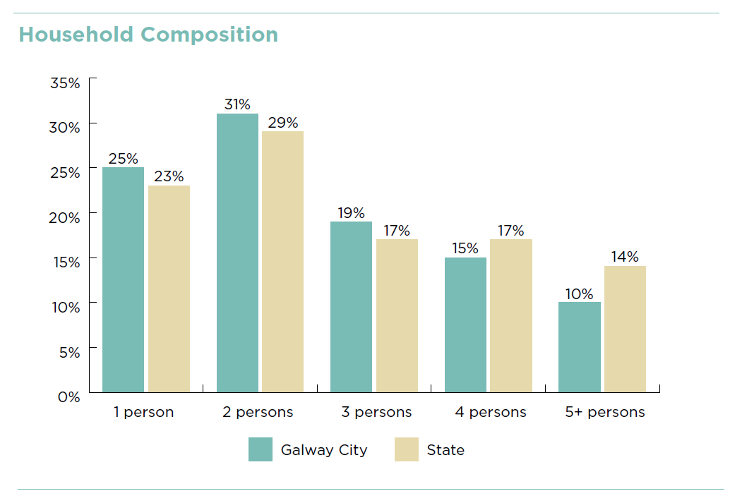
Reflecting on the most recent census statistics (2016) it is noted that there are 28,859 private households in Galway City marking a growth of 4.1% (+1,133) since 2011. The average household size was recorded to be 2.58 persons, this compares to a national rate of 2.73 persons per household. The further refinement of this breakdown into household size composition in comparison with the state is shown in Figure 1.3
Figure 1.3 Breakdown of household Composition in Galway City compared to national rate
The NPF reflected on household sizes and projects that the average household size is expected to reduce to 2.5 persons by 2040, noting that this trend towards smaller households will be more apparent in urban areas than rural areas. This shift in household size and the composition of households is important for many housing related issues and associated policies, including the needs of older people, single - person households, intergenerational housing options, and housing types to meet all life cycles.
In projecting housing requirements in general, the NPF stresses the importance of having a robust, evidence based approach for projections and in this regard the new statutory guidelines and methodologies have been prepared and aim to have an effective consistency at national, regional and local level. The Section 28 guidelines Housing Supply Target Methodology for Development Planning DHLGH 2020, provide the standard methodology that each local authority is required to use, so that there is consistency in approach with the NPF and the relevant RSES’s and accordingly, with the related NPF 50:50 scenario.
Galway City housing demand projections which have been based on these guidelines are included in Table 1.3 The preparation of the guidelines was supported by background data and research prepared by the ESRI. The ultimate objective of this was to establish a national standard for local authorities to use to estimate the overall housing demand and one that allows for a consistency in methodology between plans and therefore a reliable mechanism to inform and direct housing policy formulation at both national and local level.
Planning authorities must therefore demonstrate how their Core Strategy and other elements of their plan are consistent with the established NPF Roadmap population projections for their local authority area and accordingly, with the related NPF 50:50 city housing demand projection scenario identified by the ERSI. This approach is in contrast to previous methodologies used by local authority plans which utilised population projections to assess housing demands. The reasoning against using this historic model is that, although projections are important, the validity of the projections can only be assessed with one fixed date every five years as part of a national census of population. This tool enables more flexibility.
Applying the methodology from the guidelines and exercising the recently developed HNDA Tool (April 2021 DHLGH) the projected housing need for the city has been forecasted for the period of the plan. This approach includes for a combination of a household projection scenario (for Galway City the convergence scenario is used) and an estimate of unmet housing need combined with the number of existing homeless households, the results of which are shown in Table 4.10 of the Galway City Housing Strategy/Housing Need Demand Assessment (G.C.C. August 2021). This scenario is also used to estimate the breakdown of this projected housing need by tenure in this document. In total it is estimated that there will be a need at a minimum for an additional 4,245 housing units in the city over the plan period up to the end of 2028.
The use of the HNDA tool to project housing need for Galway City is in line with the aforementioned NPF Objective 36 to oblige local authorities to apply a standardised methodology in estimating future housing need and to enable assessment of the effectiveness of policies to deliver housing at regional, metropolitan and local level.
The HNDA is a dynamic tool, it has application that can enable the council to monitor the delivery of housing over the duration of the plan. It is sufficiently flexible to allow for adjustments in the prevailing socio-economic variables that are used in the tool’s methodology that can impact and change the projected breakdown in tenure. Using the tool can allow housing delivery to be monitoring delivery at local level and because it is a standardised tool at national level too. It can therefore contribute to timely adaptation of housing policies and also give a measure of how effective prevailing policies are in delivering the NPF targeted populations.
It provides for a scenario where housing provision can demonstrate a reflection of the increases in housing provision that can show that the policies in the NPF are beginning to have impact.
Table 1.4 Total Annual Housing Need, 2023-2028 Note: Totals may not sum due to rounding
|
|
2023 |
2024 |
2025 |
2026 |
2027 |
2028 |
Total |
|
Total Housing Need |
776 |
743 |
702 |
713 |
711 |
790 |
4,433 |
|
Convergence Projections |
744 |
711 |
670 |
681 |
679 |
758 |
4,245 |
|
Existing need |
31 |
31 |
31 |
31 |
31 |
31 |
186 |
1.4.4 Planning and Construction Activity
The Central Statistics Office (CSO) publishes dwelling completion data on a quarterly basis as shown in Table 1.5. This gives an insight into housing delivery since 2011 and identifies that the majority of housing has been delivered in scheme units over the last five years. The table also reflects the slow recovery in house building since the economic crisis and the impact of Covid-19 pandemic restrictions on construction as reflected in the decline in completion rates for 2020.
Table 1.5 CSO Completions in Galway City 2011-2021Q1 * first quarter of 2021
|
Completions |
2011 |
2012 |
2013 |
2014 |
2015 |
2016 |
2017 |
2018 |
2019 |
2020 |
2021* |
|
Single house |
21 |
11 |
16 |
8 |
16 |
12 |
20 |
21 |
29 |
18 |
6 |
|
Scheme house |
18 |
1 |
4 |
12 |
13 |
69 |
99 |
106 |
158 |
156 |
98 |
|
Apartment |
13 |
10 |
30 |
27 |
22 |
32 |
30 |
12 |
67 |
32 |
30 |
|
% Change |
- |
-58% |
127% |
-6% |
9% |
122% |
32% |
-7% |
83% |
-19% |
- |
|
Total |
52 |
22 |
50 |
47 |
51 |
113 |
149 |
139 |
254 |
206 |
134 |
Purpose built student housing is not recorded in the residential dataset by the CSO however the City Council records show that 1,060 additional purpose built bed spaces have been delivered since 2015.
1.4.5 Residential Planning Delivery
There has been significant activity in applications for residential units in recent years. Many of the larger scaled proposals have been applied for under the Strategic Housing Development (SHD) consent regime. Reflecting the pattern of historical construction consents in general, these predominantly consist of residential scheme developments with a notable trend toward more mix in housing type within these schemes to include for small scaled units accommodating apartments and duplex housing. Table 1.6 highlights the number of these extant permissions as of the 1st of September 2021. It also demonstrates the split between conventional housing and apartment /duplex housing. It includes both developments where no work has commenced and developments commenced where no housing units within the schemes have been occupied to date. This data is currently updated, monitored and mapped on a 6 month cycle and will be adapted to the future monitoring reporting structure as provided for in Appendix 1.
Table 1.6 Details on Planning Activity (September 2021)
|
Residential Developments with consents |
|
|
Total no. of Housing Units with permission |
1,936 |
|
Breakdown of permitted in number and % of Unit Type |
Conventional housing – 502 (26%) Apartment/Duplex Units - 1434 (74%) |
|
Student Bed Spaces unbuilt |
2,036 bed spaces |
|
Residential Proposals at Application stage (SHD/Part8/Part 10 and applications under appeal to An Bord Pleánala by number of units) |
800 housing units |
1.4.6 Housing Target for the Core Strategy
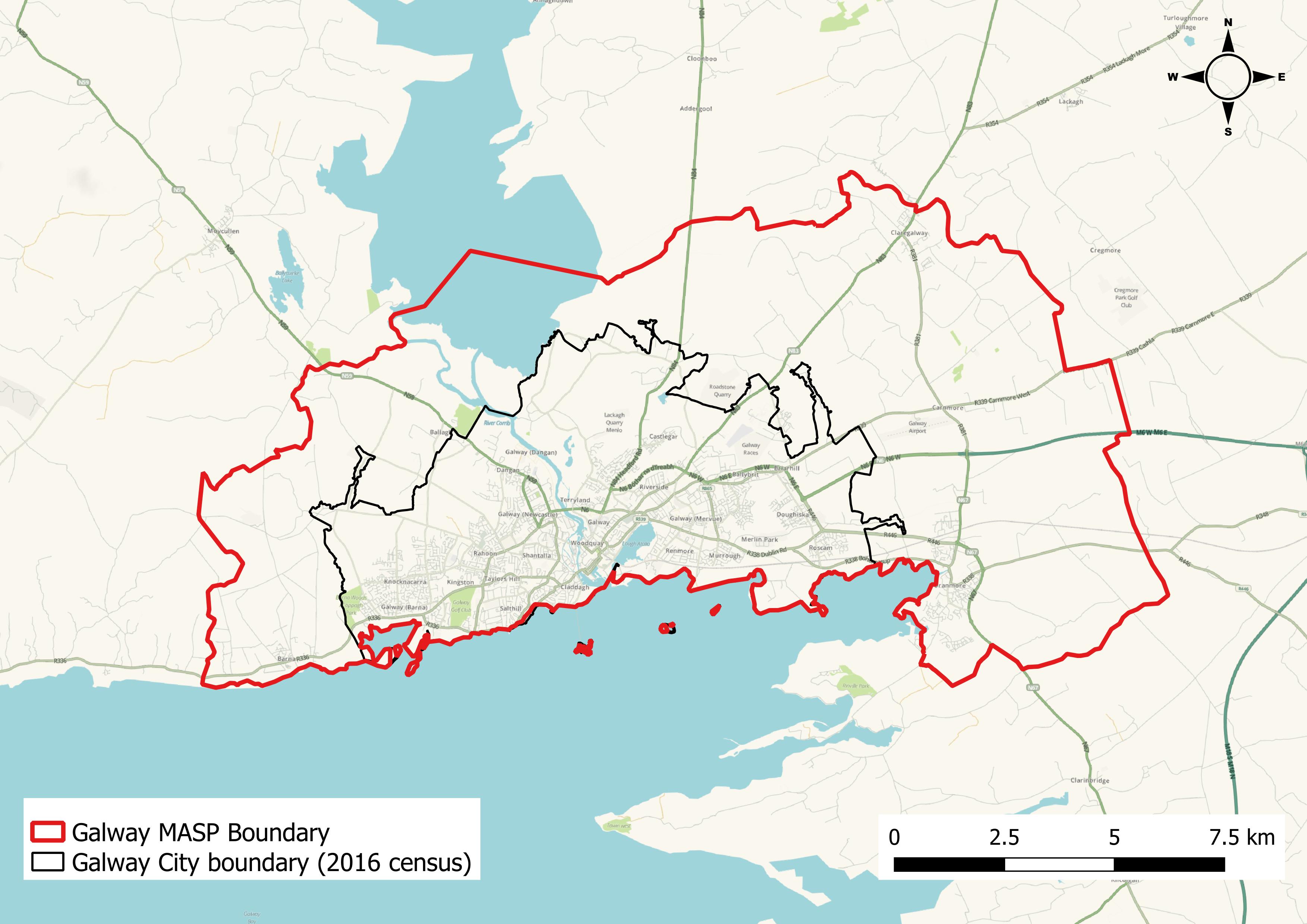
Galway City’s development plan, unlike other local authorities, particularly those including county areas does not have a need to prepare a settlement hierarchy being a single settlement area. However the Core Strategy acknowledges the broader spatial context of the MASP area and the associated strategic planning framework which identifies Strategic Growth Areas and opportunities for regeneration. The MASP has also identified the key infrastructure, services and facilities that will be required to support sustainable city growth and regeneration. It gives direction on how the NPF population targets can be met in accordance with the principles of sustainable development with the aim to deliver compact growth. The population targets set out in the MASP are for the Galway MASP area to grow by 27,500 to the year 2026 and by a further 14,500 to the year 2031. For the city and suburbs, the population targets set out in the MASP are to accommodate 23,000 persons to 2026 and a further 12,000 persons to 2031, this increase in housing need is to be substantially delivered within the existing built-up footprint.
Figure 1.4 MASP area as defined in Metropolitan Area Strategic Plan
It is acknowledged that these population forecasts are targets and may not be achieved by the benchmarked years of 2026 and 2031, but regardless provision should be made to facilitate the opportunity for such growth on zoned lands within the existing local level plans in the overall MASP area as shown in Figure 1.4. This will support the objectives of the NPF and the RSES to deliver Galway Metropolitan area as a national strategic growth area with the ability to accommodate the compact sustainable growth levels envisaged in the NPF to be reached by 2040.
The MASP identifies areas of growth potential in the settlement and development strategy for the city and makes inclusion for growth in the county settlements within the metropolitan boundary. Together these will contribute to the critical mass needed to make Galway City and environs achieve regional city scale and when combined with the other regional cities to function as a realistic alternative to Dublin and achieve a key NPF national strategic output.
Table 1.7 MASP Strategic Growth Areas
|
Metropolitan Area Strategic Plan Growth Areas |
|
Strategic Growth Areas - Ardaun LAP Area |
|
Regeneration Lands at Ceannt Station Quarter, Inner Harbour and Headford Road LAP area -Consolidation of the existing neighbourhoods of Knocknacarra, Rahoon, Castlegar and Roscam - Murrough LAP Area |
|
Galway County Council MASP Area - Baile Chláir, Bearna, Oranmore and Briarhill are identified to accommodate a portion of the MASP population growth targets (See Galway County Council Draft Plan 2022-28) |
Metropolitan Area – Galway City
The period of the plan extends from 2023 to the end of 2028 and is therefore the focus of housing target for the Core Strategy. The RSES in Section 3.6 has included a growth target for the city metropolitan area to reach 23,000 persons by 2026 and a further 12,000 persons by 2031, equivalent in total to an increase of 35,000 persons by the end of 2031.
The HNDA exercise as explained in Section 1.4.3 has the associated purposes to allow for a standardised national and regional monitoring of settlement patterns and also reflect historical trending. In contrast the growth targets in the NPF and the RSES are more ambitious and driven by the strategy to grow the regional cities and their environs to reach critical level of settlement scales that will redress the current growth patterns, build stronger regions and accord with the national policy objectives, specifically NPO 2 (a) in the NPF.
In this regard it is considered that the settlement approach in the Core Strategy should ensure that there are sufficient lands with suitable zoning objectives that can accommodate housing for the targeted growth population for Galway City under the MASP that is an increase of 35,000 persons from the recorded population levels in 2016. This approach supports the policy interventionist approach as included for on both the NPF and the MASP. It has the added requirement under national and regional objectives that at least half (50%) of all these new homes targeted in the regional cities, which includes Galway City, should be accommodated within the existing built up footprint.
This requirement to estimate housing for the RSES high growth scenario is outlined in Table 1.8. In view of the current average prevailing household size at 2.58 persons in the city and the NPF’s reference to expected national household size of 2.5 people per household by 2040 the latter scale of household size has been applied to the targeted future population and used in determining land use residential capacity and housing unit target delivery.
Table 1.8 – Housing Target for Core Strategy using high growth scenario *Extrapolated to end of 2021
|
|
2016 |
2028 RSES High Growth Target |
|
Population |
78,668 |
106,664 |
|
Increase in Population |
----- |
27,996 (Annualised Population target) |
|
Total Housing Stock |
28,859 |
41,500 (adjusted for vacancy & obsolescence) |
|
Housing Target 2016 – 2028 |
---- |
12,641 |
|
Excluding CSO Housing Completions 2016-2021 * |
1,397 |
11,244 |
1.5 Settlement Capacity Audit
1.5.1. General
A Settlement Capacity Audit was undertaken in order to inform the preparation of the Core Strategy and to meet the specific requirements in relation to Section 10 2(A) (c) of the Planning & Development Act 2000 (as amended) with respect to areas zoned for residential use and a mix of residential and other uses. The purposes of preparing the audit was to analyse the existing capacity of the city to accommodate residential development and provide the basis on which the future housing targets as identified in Table 1.8 are to be allocated.
This included for a comprehensive review of all existing residential zoned lands and lands zoned for a mix of residential and other uses. It was guided by the range of principles which reflected national and regional policy. These included the agenda on securing compact and sustainable growth. In particular there was significant focus in the review on reusing previously developed “brownfield” lands, building up infill sites and redeveloping existing sites and buildings. These were examined in the context of existing and planned public transport provision, the location of services, employment and community facilities. These sites are now classed in the Core Strategy as Regeneration and Opportunity Sites. In addition existing undeveloped residential lands were reviewed and also residentially zoned lands where infrastructure delivery may now permit higher densities. This approach also reflects the need to support a reduced carbon footprint. It also reflected the advantages where medium and higher densities can support improved local community services and facilities and sustainable transport links for daily journeys and in general have the capacity to transform vitality of place and contribute to improvements in lifestyle choices.
In addition to reviewing the zoning objective in relation to zonings that support residential development, cognisance was also taken of the capacity for housing yield anticipated in the Ardaun Local Area Plan 2018-2024. The preparation of this plan was driven by the need to give a framework to the urban extension of the city on lands designated for both settlement and development on the east side of the city. Development at Ardaun is anticipated to be delivered in two phases south and north where the dividing boundary is determined by the M6/N6 and delivery is allied to the service program for infrastructure.
Ardaun has a national designation as a Major Urban Housing Delivery Site (MUHDS), a designation which the Department sees as one of a number of strategic sites that could deliver housing of scale in the medium term. These lands have significant potential to meet housing need as targeted in the RSES and also have potential to fulfil the aims of an Urban Development Zone as provided for in Housing For All (2021) DHLGH. The delivery of Phase One, the southern section, is considered appropriate to be included in the calculation of yield potential for the currency of the 2023-29 City Plan.
1.5.2 Settlement Capacity Audit
The Settlement Capacity Audit calculated the undeveloped residential zoned lands at 143ha. These lands are all located within the existing built up footprint of the city and represent mainly consolidation of existing residential areas. The Plan proposes a very marginal change from the 2017-23 City Development Plan in the amount of new land zoned for high density residential purposes amounting to an additional 22ha which is included in the 143ha. In line with NPF and RSES and the need to deliver compact development and reuse of brownfield sites, these have been specifically identified and assessed for their potential capacity to deliver housing. This is reflected in the estimated potential yield that can be delivered on these key Regeneration and Opportunity Sites which can support a mix of uses including a significant scale of housing.
With respect to the undeveloped residential zoned lands the yield was established using policy guidelines as provided for in Sustainable Residential Development in Urban Areas, Guidelines for Planning Authorities (2009) in combination with an audit of recent planning permission densities achieved on similar sites. Where site specific criteria was relevant and which impacted the suitability for housing this was factored into the estimation to ensure a level of robustness.
The Regeneration and Opportunities Sites which number 20 in total were reviewed individually. They include lands suitable for a mix of uses with capacity for residential delivery. The identification of these sites included legacy regeneration sites from Galway City Development Plan 2017-23 and a number of additional sites. Many of these sites generally have spatial advantages such as close proximity to the city core, a location along an existing /planned high frequency bus route, good proximity and access to employment, services and amenities. Recognition of their relative suitability for development with a mix of residential use was factored into the assumptions applied at a site specific level in order to provide an estimation of yield. Where sites had the benefit of permissions for residential/part residential uses these were used in yield calculation. In general, otherwise an assumption of residential yield and density was arrived at which included application of recent densities achieved on comparable sites, site specific characteristics, and application of the Sustainable Residential Development in Urban Areas, Guidelines for Planning Authorities (2009). More specific detail with regard to each of these sites and the policy direction for delivery of uses including housing is outlined in Chapter 10.
In advance of devising the Core Strategy an infrastructure audit was prepared in conjunction with stakeholders in relation to physical infrastructure availability. An assessment of capacity to service lands was carried out. This focused on facilities such as water supply, foul sewer drainage, surface water, public transport infrastructure, roads streets and footpaths. This was prepared to assess capacity for servicing new development and to accord with the tiered methodology approach in the NPF for the approach to classification of zoned land.
Essentially Tier 1 are serviced lands in the built up footprint and Tier 2 are lands within the built up footprint or contiguous. An additional category relates to lands that can be described as Strategic Development lands – these can include lands that have potential to be developed over a timescale greater than the single six year cycle of the plan. In this regard the lands included in Phase 2 (North) of the Ardaun LAP would qualify as this strategic reserve. These lands are not scheduled to be supported by infrastructure before 2029, but it is important that it is included to provide for a strategic settlement portion of NPF/RSES 2040 population delivery and for a longer term infrastructure investment guide. The potential population yield from Ardaun LAP Phase 2 however is not included in the Core Strategy settlement capacity for the current plan 2023-29 Plan. Table 1.9 gives a composite picture of lands zoned that can accommodate housing and includes a yield potential and a tiered servicing classification. This is supported by Figure 1.5 which shows the distribution of lands that has potential to deliver on the housing targets included in the RSES/MASP.
Table 1.9 Core Strategy Table 2023-29
|
|
Lands |
Potential Development Yield |
Zoning Tier |
|
1 |
Residential Zoning |
5,720 |
Tier 1 |
|
2 |
Regeneration and Opportunity Sites |
3,411 |
Tier 1 |
|
3 |
Ardaun Phase 1 |
1,980 |
Tier 2 |
|
4 |
Ardaun Phase 2 |
2,660 |
Strategic Development Lands where Infrastructure servicing is anticipated to be post 2028. |
|
|
Core Strategy Total for 2023-29 |
11,111 (total of 1, 2 and 3) |
|
1.5.3 Core Strategy Statement
The Core Strategy has been developed in line with the vision for Galway City as identified in the Strategic Goals. This focus envisions the city to sustainably develop, strengthen and nurture success, become a city of scale and continue to be driver of regional growth.
This vision includes for a settlement strategy that supports the city to transition to a low carbon, climate resilient city. This can be achieved by implementation of a compact growth approach, increased integration between land use and transportation, increased sustainable mobility and sustainable use and management of environmental resources.
There is a focus in the strategy to facilitate development within the strategic framework of the Galway Transport Strategy and to align employment and housing growth along existing and planned transport corridors. This will increase active travel, that is walking and cycling and usage of public transport.
To deliver on the compact growth approach, the strategy seeks to concentrate a significant amount of development that is, at least half of all new homes within the built footprint of the city and thereby accord with sustainable principles and the NPF/RSES objectives. This will allow for efficient use of existing services, public transport and facilities and in some areas can lead to transformational change bringing additional footfall, new life and facilitate shorter, more sustainable journeys to employment, and recreation opportunities. Policy guidance included in the plan on housing densities and mix, building height, design and layout all contribute to achieving economic use of land and delivery of compact growth. These policies have evolved in conjunction with the outcomes of the Building Height and Density Study prepared as a supporting document for the plan and in line with Section 28 Ministerial Guidelines.
The approach to compact growth is further supported by an increasing focus on place making, public realm measures and enhancement of amenity and recreational opportunities. The delivery of these qualitative measures will be guided by the Galway City Public Realm Strategy and the Recreational Needs Study and its successor and General Urban Design Standards. It is a given that compact growth of itself will not deliver sustainable neighborhoods and the vision for the city is that the delivery of housing is balanced with the provision of community infrastructure which includes a range of critical facilities including good open space, recreation facilities, good transport options and appropriate social and community infrastructure.
In the interests of delivering compact growth the zoning of additional lands for residential use has been constrained, existing residential areas of the city will grow but through consolidation and modest densification. These areas include the newer suburbs of Knocknacarra, Castlegar and Doughiska, where there are opportunities for additional local employment growth, services and facilitates and for improved public transport and active mode measures.
The Core Strategy recognises, in line with the NPF and RSES direction, the significant potential for a number of brownfield sites in the city to contribute to the delivery of housing. Major potential exists in particular at Ceannt Quarter, the Inner Harbour, Dyke/Headford Road area and at Sandy Road. The development of housing at these locations in conjunction with other mix of uses can improve the environment and revitalise and transform these to vibrant, living locations. Chapter 10 identifies these sites as Regeneration and Opportunity Sites and elaborates on the objectives for these sites that guides how they can contribute to the growth of the city while also complementing the character, sensitive environment, cultural legacy and built form of the city.
The main urban extension of the city at Ardaun, which is a main focus of the settlement strategy demanded detailed spatial guidance in the form of a Local Area Plan which was adopted in 2018. This area has potential to be a major new residential and employment settlement in the city. It provides a continuous link out from the city and is integrated with the transport strategy and capable of benefiting from planned investment in bus connects, active mode networks and commuter rail investment at Garraun. It will provide opportunities for high density residential development structured and co-ordinated with other essential community services. It is well placed to develop good employment opportunities having close physical links with the existing technology parks at Mervue, Ballybrit / Parkmore and strategic IDA sites at Oranmore and Athenry. It is also well placed to link in with and take advantage of the proximity of the higher level institution at GMIT and the significant health institutions at Merlin Park Hospital and the Galway Clinic.
Reflecting the recent years of low housing construction and a deficit of investment in infrastructure no housing has been constructed in Ardaun to date. Future delivery will be strongly linked to the stimulus needed from additional infrastructural investment. Notwithstanding this, an implementation strategy to address these constraints is progressing. This included the preparation of an Area Based Transport Assessment (ABTA) for the LAP lands which supported applications for successful allocations under both rounds of Urban Regeneration Development Funding (URDF). This funding includes for an imminent upgrade to the primary access to the southern section which will provide bus priority, upgrades pedestrian and cyclist facilities and for the assessment of the location and design of an additional access route into the LAP lands. Design work by Irish Water was also carried out under the Irish Water Network Extensions and additional work is scheduled and has been commissioned by the Council.
Lands at Murrough, although primarily designated for recreation and amenity purposes, will also sustain mixed uses including an element of housing and a significant delivery of amenity. This in time will service both the adjacent third level institute at GMIT and the existing and planned population on the east of the city. It is anticipated that an LAP will be brought forward during the currency of this plan and that recreational facilities and infrastructure may be delivered but housing is unlikely in the period of this plan.
The Core Strategy has, as demonstrated in Table 1.9 ensured that sufficient lands are available to meet the RSES/NPF targeted growth and need for the delivery of the associated demand for housing in the City including the allocation for the city MASP area. The lands available constitute a mix of consolidation of existing residential lands which has capacity to deliver 5,480 homes and the Regeneration and Opportunity Sites as shown in Figure 1.5. A review of the Regeneration and Opportunity Sites indicate a potential yield of 3,411 homes. To supplement this and ensure a readiness in the city to meet the ambitions for significant growth targeted in the RSES/MASP for Galway as a regional city Ardaun Phase 1 capacity yield of 1,980 is required for the period up to the end of 2028. It is considered that Ardaun Phase 2 will require infrastructure which is not committed to as of yet and can be classified as Additional Provision and support the continued realisation of the longer term RSES population targets for 2040.
As stated previously it is recognised that the potential yield can deliver more housing than what is included for in the ESRI and HNDA projections for delivery for the period up to the end of 2028. However this latter calculation represents a very conservative growth rate when viewed in the context of the NPF/RSES population targets up to 2031. Other factors are needed to be considered also when reviewing the settlement strategy for the city. The current proposal represents a minimal increase of 21.8ha in lands specifically zoned for housing from that which already exists in the City Development Plan 2017-23 plan and in the Ardaun LAP. A significant amount of the additional yield is anticipated to be delivered on the Regeneration and Opportunity Sites, all of which constitute brownfield sites located close to the city centre which can sustain in general a mix of uses with potential for high density compact growth. Notwithstanding that these are being brought forward in the current plan it is unlikely that they will all be delivered during the period of the plan. Development is likely to occur at a pace that reflects the proposed additional investment in public transport, public realm, services and the momentum of investment and the construction industry to gravitate towards new formats of development delivery. In view of this, it is considered that the approach to the settlement strategy for the city is appropriate from national and regional policy direction, from a land use, plan led perspective and also affords clarity to the general public and investment community.
1.6 Employment Development
The Guidance Note on Core Strategies (2010) indicate that the Core Strategy should involve an appropriate level of analysis that will ensure sufficient lands are identified for employment purposes at suitable locations taking proper account of national planning policies. The guidance document does not provide a method for determining an appropriate amount of zoned lands for employment purposes in the Draft Plan. In view of the changing nature of work, new technologies and the large employment catchment of the city this projection of need by land area does not lend itself to precise scientific methodology. On a regional basis the NPF 2040 scenario targets a growth of an additional 115,000 people in employment in the Northern and Western Region. It is anticipated that Galway as a key regional employment base, located centrally along the Atlantic Economic Corridor will support many of these future jobs, providing employment for the targeted population for the Galway MASP and the significant employment catchment of the city. The RSES in its Growth Ambition 1 – Economy and Employment recognises the ‘Galway Catchment’ and the continued focus of international and national traded, high value job investment in such urban areas. In addition the economy of Galway being diverse supports employment in education, tourism, commercial and healthcare services. The RSES also recognises the growing and emerging economies which are present in the city and region associated with the marine, culture and arts, gastronomy and sustainable energies. The MASP strategy for the city is to continue to support the employment growth at the strategically located enterprise lands within the city and environs and to focus on the potential for employment on the key Regeneration and Opportunity Sites within the city.
This approach is reflected in Chapter 6 and Chapter 10 and the land use zoning map which sets out the main policies and objectives that support an environment that will encourage job creation. It is considered on review of the quantum of zoned lands, that the scale, nature, distribution and capacity of lands identified as supporting employment in the city and the MASP area of the county plan will be sufficient to meet the range of employment types and at locations that are integrated with the strategy for sustainable transport and co- ordinated with the settlement strategy also.
In general the Core Strategy includes for new employment opportunities at the existing business and technology lands at Ballybrit, Mervue, Dangan and Knocknacarra. The potential for job creation at Ardaun is also part of the long term development of the city. The IDA lands within the city environs at Parkmore and Oranmore are also seen as having significant potential to accommodate future large, particularly FDI investment, in the greater MASP area.
The major regeneration sites located in the city centre at Ceannt Station Quarter, Inner Harbour Headford Road and Nun’s Island are of such a scale and nature that can satisfy the demand for additional commercial uses and office technology of both an international and indigenous nature. These locations can provide high quality, attractive, city centre locations adjacent to sustainable transport links while also delivering on their potential for high density, residential development. They offer a sequential solution to the expansion of the city centre, close to a major transportation hub, reinforcing the prime role of the city centre in both Galway City and the MASP area. Developments at construction and planning stages have already affirmed interest in these locations for employment and city living. Expanding the city in this direction not only responds to future enterprise floor space demand it also can, with good design enhance the image of the city, the tourism function and allow for an expansion to a scale commensurate with the designation of Galway as a NPF regional city.
In addition to the large regeneration sites the significant scale of Industrial lands at Mervue, located close to the city centre, offer good opportunities for expansion through densification and re-organisation. These are complemented by the proximity of an opportunity site at Crown Square, a large scale adjacent office campus development under construction which shares a site with a consented large scale, high density housing scheme. Other smaller manufacturing enterprises located at Liosbán Industrial Estate and Tuam Road enterprise area are considered very important in particular for the indigenous economy, start-ups, small businesses and warehouse ventures.
A significant element of employment in the city is concentrated on hospitals sites and educational campuses, in particular the third level institutions and also in other government services. Most of these large institutions have capacity for expansion on undeveloped campus lands, through intensification and re-development on their existing campus sites and/or buildings.
The city centre area is the main focus of commercial activity. The adjacency of key regeneration sites at Ceannt Quarter, Inner Harbour and the Dyke/Headford Road area all offer opportunities for sequential expansion. As the city centre area is also targeted for improved public transport services and associated infrastructure, active travel mode measures and for transformative public realm projects these sites will benefit from this investment which add to the attractiveness and liveability of this location.
Notwithstanding the need for land and infrastructure to facilitate job creation, quality of life factors will also influence both skills attraction, skills retention and competitiveness of location. Implementation of the GTS measures, the Public Realm Strategy projects, policies on place making, protection of the built and natural heritage and provision for and delivery of education, community services and supporting amenities will be key also in enabling the RSES anticipated strategic employment growth for the City MASP area.
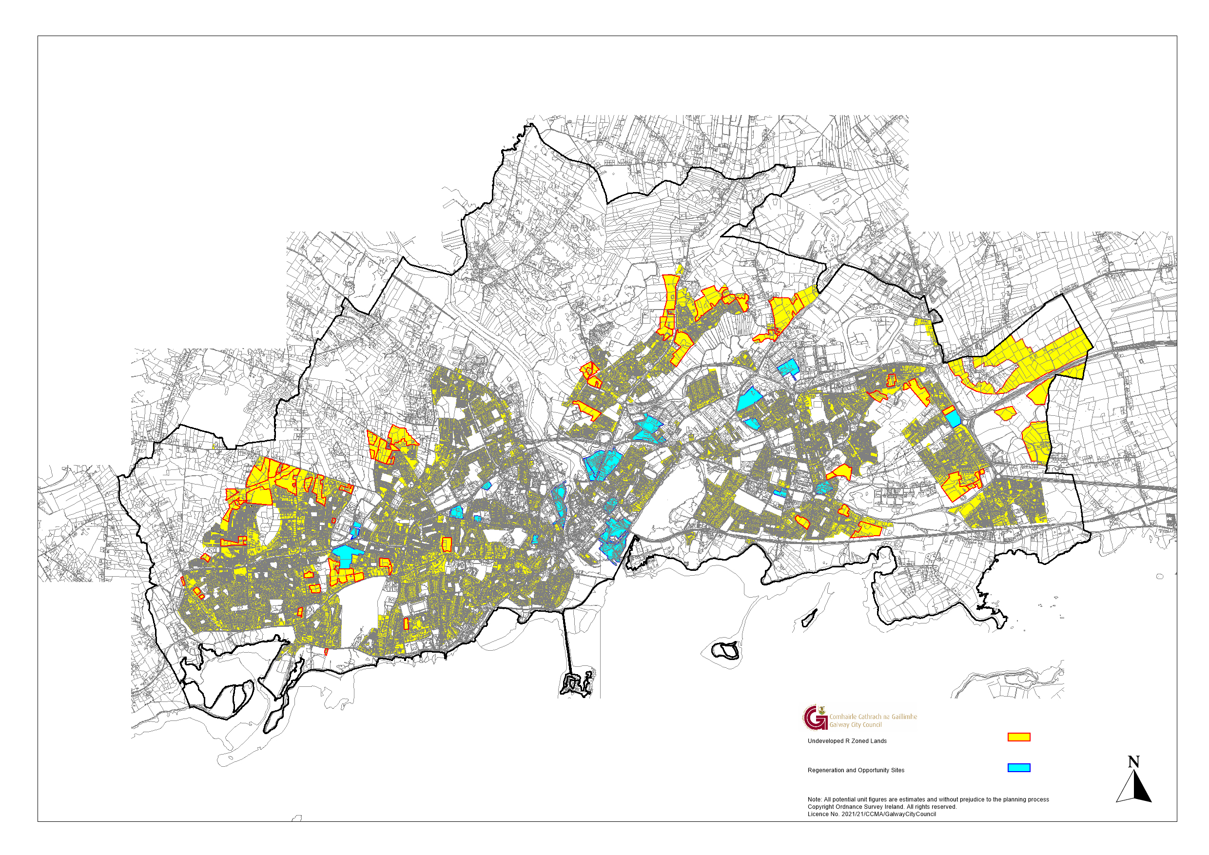 Figure 1.5 Built-up footprint, Residential Zoning (undeveloped lands within red boundaries) and Regeneration and Opportunity Sites
1.7 Retail Strategy
Retailing is a significant contributor to the commercial life of the city and an essential part of the economy and can give support in delivering sustainable settlement patterns. There is a requirement for the Core Strategy to contain information to show that in setting out objectives regarding retail development, the Planning Authority has had regard to Section 28 Retail Planning Guidelines (2012). This approach stresses the need to have proactive polices that can both safeguard existing retail floor space, particularly core retail areas that give vitality to place and community and also to give appropriate direction for expansion in floor space.
The guidelines recommend a joint retail strategy be prepared for Galway City and County. In collaboration with Galway County Council the current strategy has generally pursued the agreed retail hierarchy in line with the settlement strategies for both Draft Plans and in alignment with the synergies in the respective transport strategies. This will be supplemented by more rigorous analysis in 2022/23 when the retail sector reverts to more normal market conditions after the lifting of all Covid-19 pandemic restrictions and the ending of government supports. This will afford a more robust understanding of the impact of the disruption in the retail sector, triggered by globalisation, technology innovation and changing consumer sentiment which has been accelerated by the Covid-19 pandemic and which has also been impacted by Brexit and the ongoing supply chain challenges.
In the interim the strategy affirms that Galway city centre is the primary retail centre in County Galway. In this regard the strategy objective is to promote and further develop the level of retail provision in the core retail area commensurate with that as envisaged to service the targeted growth and catchment for Galway, as the largest urban area in the region and one of four designated NPF regional cities and a significant tourism hub. The city centre includes a number of regeneration sites that can seamlessly link in with the existing primary and secondary shopping streets, support additional retailing with capacity for new formats and larger floorplates and sequential growth in the retail offer in the city.
Within the city offering at level 3, four District Centres are located at existing suburban location at Doughiska, Knocknacarra, Westside and provision is made for a District Centre at Ardaun where significant settlement is anticipated. At a lower tier Neighbourhood Centres are identified as location for daily top up shopping, which can be accessed easily within neighbourhoods. At the lowest tiers, provision is made to facilitate local shops preferably clustered with other neighbourhood services /amenities.
Policies and objectives for all formats shows that there is sufficient support and opportunities for retailing in the city. These also give direction regarding the need for environmentally efficient design and high quality architecture. The accelerated change in retailing also means that there is a need to evolve from a location for product display and purchase to a location where customers can connect with brands and enjoy a more layered experience than just the physical store. Encouraging complementary mix of uses in shopping areas and implementation of proposed measures in the Public Realm Strategy will also give confidence for future investment and growth in the sector.
The transport strategy for the city includes plans for high frequency bus routes that can access the existing and planned District Centres. The roll out of investment in the network of infrastructure to increase sustainable mobility will further improve links to District and Neighbourhood Centres, combined with measures to improve permeability. Encouraging and protecting provision at the lower tiers will also support the concept of a ’15-minute city’ where the daily needs of communities can be accessed within a 15 minute walk, cycle or by public transport.
1.8 Supporting Strategic Policy Documentation
1.8.1 Environmental Strategy
The Core Strategy has also been informed by the Strategic Environmental Assessment (SEA), the Habitats Directive Assessment which have been undertaken in conjunction with the process of preparing the Draft Plan. This has influenced the development growth option pursued in the Core Strategy and also where necessary enabled policies and objectives to be tailored to ensure the impacts on the environment, natural heritage and biodiversity has been reduced to ensure a balance between enabling future urban development of the city while protecting the environment and natural assets.
The Strategic Flood Risk Assessment (SFRA) provided broad guidance with respect to the assessment of flood risk which has consequently influenced strategic land use decisions with direction on location and type suitability. These form part of the plan and are detailed as supporting documents.
1.8.2 Climate Change Strategy
Planning legislation contains a mandatory objective for development plans to address measures to reduce energy demand, reduce greenhouse gas emissions and address climate change adaptation. Taking this into consideration the Core Strategy has set out how the plan will promote this objective in particular with regard to achieving sustainable settlement and transport strategies. The balance of chapters outline the sectoral policies and objectives that need to be implemented to achieve such measures including for a need to transition to a low carbon climate resilient city. Chapter 2 draws all these policies and objectives together to give the overall strategy. This approach adds to the current Galway City Council Climate Adaptation Strategy 2019-2024 which will be further embellished by additional climate actions after the full implementation and guidance on the Climate Action and Low Carbon Development (Amendment) Act 2021 which includes for the preparation of specific Local Authority Climate Action Plans.
1.8.3 Galway Transport Strategy
The GTS is a strategy by Galway City Council prepared in conjunction with Galway County Council, the NTA and TII. The aim of the strategy is to address current and future transport requirements in the City and County catchment area. It incudes for a range of measures that focus on an integrated and sustainable solution with a strong objective to reduce car dependency in favour of public transport and active modes. It is anticipated that many of the associated projects will be commenced during the currency of the plan period. In line with good planning principles this investment is aligned with the settlement and development strategy for the city. Chapter 4 gives more elaboration on the strategy and the Core Strategy Map gives visual representation of the main settlement and transport focus.
1.8.4 Public Realm Strategy
The Galway Public Realm Strategy sets out a vision and strategy for improvements to guide future investment and development in the network of public and green spaces in the centre of the city. This vision builds on previous investments. In conjunction with the GTS it seeks to redress the balance in favour of pedestrians and cyclists over vehicular traffic and capitalise on this by creating a high quality public realm, upgrading the quality of the physical fabric, enhancing biodiversity and exploring opportunities to create new spaces.
1.8.5 Galway City Urban Density and Building Height Study (UDBHS)
This study was commissioned in the context of reviewing the application of Section 28 Ministerial Guidelines to Urban Development and Building Height Guidelines (2018) to Galway City and to inform the Core Strategy. The study provides a coherent analysis of the existing spatial structure. It reviewed where the potential for intensification through increased densities and/or height could achieve the most efficient and effective use of land and make a positive contribution to the character of and liveability of the city and the need to accommodate the target increase in population sustainably. It gave consideration to the suitability and sensitivity of areas to change and the need to respect the unique built and natural heritage and character of the city. It focused on the opportunities afforded by investment in sustainable transport and the distribution of services and amenities as well as reviewing the emerging potential of the Regeneration and Opportunity Sites for mix of uses. Critically it emphasised the need for any increase in densities to be framed in quality architecture and adherence to good urban design principles.
1.8.6 Local Economic Community Plan (LECP) Galway City
The LECP focuses on identifying gaps and delivering positive step changes that will deliver the economic and social consolidation and enhancement of Galway City. The focus of the plan is on collaboration and inter-agency work, with an emphasis on clear and measurable actions that add value to the city. Annual action plans are prepared based on the strategic objectives and actions outlined in the LECP, that reflect this proposed added value
The preparation of the LECP is in line with the role assigned to Local Authorities as having a primary responsibility for leading economic, social and community development in the city. The purpose of the LECP, is to set out the objectives and actions needed to promote and support this economic development and the local and community development. It represents a shared plan for Galway City with the community element having been prepared by the Local Community Development Committee (LCDC) and the economic element having been prepared by the Local Authority, through the Economic Development Strategic Policy Committee (SPC). The Core Strategy has taken cognisance of this plan and associated actions in both land use zoning and policy objectives and will endeavour to reflect the emerging action in the emerging new LECP.
1.9 Core Strategy Map and Core Strategy Table
The Core Strategy Map in Figure 1.6 and Table 1.9 set out a land use strategy to enable the vision for Galway City to transition to a low carbon, climate resilient city lead by a strategy for compact growth, increased integration between land use and transportation, increased sustainable mobility opportunities and the direction sustainable use and management of environmental resources. The population targets for Galway City MASP area are distributed in three general directions. Firstly to grow and enhance the existing network of suburban neighborhoods through consolidation and appropriate levels of densification supported by measures to enhance physical, community and social infrastructure and place making. The designated Regeneration and Opportunity Sites are deemed critical to the delivery of a compact, livable city. These sites through regeneration, consolidation and delivery of a broad mix of uses can create new vibrant neighborhoods, supported by community infrastructure, new public spaces, an offer of choice in house types and tenures and demonstrate the advantages of sustainable urban living. Ardaun, an urban extension of the city, with the benefit of a Local Area Plan can in phase 1 support the NPF target population and associated development for the plan period also. Integrated in plan with sustainable transport investment, proximate employment opportunities and community services this planned urban extension will provide for structured growth at an appropriate location.
The approach being pursued has been prepared and informed by an infrastructure audit which is in accordance with the National Policy Objective 72(a) of the NPF differentiated between Tier 1, serviced lands and Tier 2, serviceable within the life span of the plan. Longer term strategic lands are also referenced that will require infrastructure which is not committed to as of yet and can be classified as “additional provision” and support the continued realisation of the longer term RSES population targets for 2040. While the NPF tiered approach does not include for community infrastructure this is acknowledged as key to supporting sustainable neighborhoods and is included for in more detail in Appendix 1.
The Core Strategy Map as provided in Figure 1.6 shows alignment of settlement with transport, commercial and development centers. It reaffirms the rational for land use zonings and site specific objectives as set out in the plan. It provides confidence with regard to the location of lands designated to meet the NPF/RSES growth targets within the city up to the end of 2028. It gives a clear direction to all stakeholders as to where more detailed planning and investment is required to deliver physical infrastructure, housing, transport, all the supporting neighbourhood services and amenities, employment and investment in urban design and place making at the local level.
The associated Core Strategy Table highlights how the NPF/RSES/MASP population targets are distributed within the city area. This targeted growth is ambitious and if not met by 2029 ensures a capacity for a resilient and rational growth lead by a sustainable and compact growth agenda that can continue in the subsequent years.
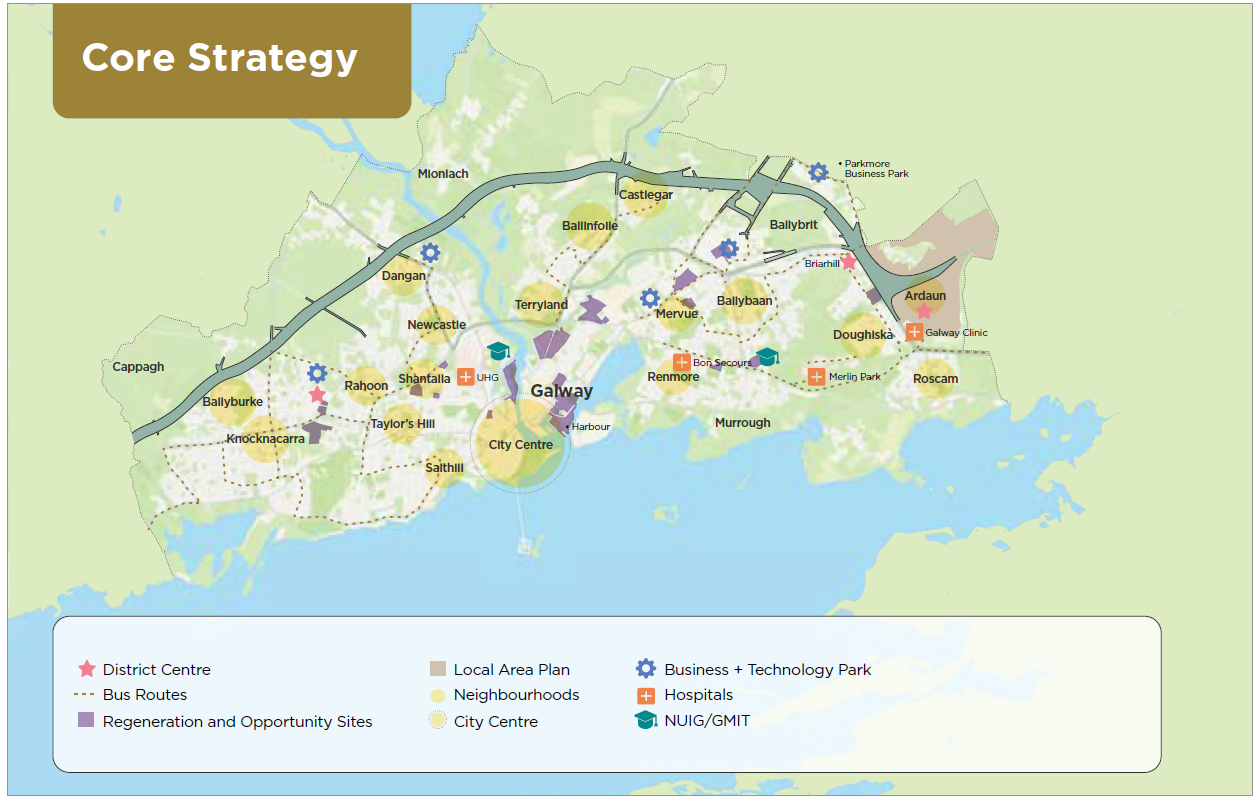
Figure 1.6: Core Strategy Map Table
1.10 Implementation
The success of the City Development Plan requires a continuous link from adoption to implementation and delivery. This requires that an implementation structure must be established to ensure that the Planning Authority maintains a continuous focus towards the implementation of the policies and objectives. This needs the plan to include for a methodology that affords measurable monitoring and analysis and a reporting structure that allows for a review of effectiveness over the six year cycle.
This approach expands on the statutory requirement for a two year progress report. It reflects that development plans require that the myriad of functions within local authorities, relating to areas such as housing, amenities, transport, infrastructure servicing and economic development contribute to delivering on the vision for the city. It allows for a mechanism to facilitate efficient co-ordination and a proactive land management approach. It can facilitate direct engagement with other key stakeholders, including the community and investment interests, ultimately with the objective of timely decision making and exploration in innovative problem solving. With a focus on the monitoring of the Core Strategy and the Development Plan policies and objectives, a dynamic approach to delivery is more likely and this can enable a link to be established with the concurrent SEA monitoring requirements.
Such an approach can link in more seamlessly with the RSES auditing and NPF target reviews. In this regard the Draft Plan has included in Appendix 1 the structure and format that will be activated to provide for plan monitoring.
1.11 Masterplans and Framework Plans
The major regeneration schemes in the city will have a significant impact on Galway’s growth, evolution and future character and success. All of the major Regeneration and Opportunity Sites will be required to be the subject of a masterplan/spatial framework plans. This will facilitate a clear strategy for development and set the context for the more detailed design elements relating to use, buildings, spaces and their interrelationship. To support the preparation of these frameworks for development details of the intended outcome, a vision for each site is included for in Chapter 10 and guidance principles are provided in Chapter 8 and the supporting document, the Urban Density and Building Height Study.
For the Headford Road and Murrough area, Local Area Plans will be prepared in order to provide a more detailed strategy for these specific areas. This in particular is because they include for areas which require urban renewal, the Headford Road area and as in Murrough where they can provide for large scale planned recreational and amenity, including improved access to the coast for the eastern side of the city. The Local Area Plans for these areas will identify and analyse the various issues of relevance, before establishing and setting out principles for the future development of these areas.
| Policy 1.4 Core Strategy |
|---|
|
Contents
Observations
Observations
Chapter 1 - Strategic Context and Core Strategy / All Chapters
Include the promotion of health and wellbeing as a strategic goal of the Galway City Development Plan. It is important that this is included in the plan as all government department and...
Introduction, Strategic Context and Core Strategy
Chapter 1 Introduction, Strategic Context and Core Strategy
The stated Strategic Goal is:
“3. Commit to climate...
SECTION 1: INTRODUCTION, STRATEGIC CONTEXT & CORE STRATEGY
PAGE 16 IN PDF (Page 14 in actual plan), under 1.2: STRATEGIC VISION FOR GALWAY CITY: Aspire to make Galway an equal and inclusive city, particularly through facilitating all forms of social...
Projected school place requirements
Submission outlines projected school place requirement arising from the draft CDP