The declaration by government of a climate and biodiversity emergency was a reaction to the global decline in biological diversity. The National Biodiversity Action Plan 2017-2021 (NBAP) attempts to...
Chapter 5: Natural Heritage, Recreation and Amenity
Closed28 Feb, 2022, 9:00am - 13 Apr, 2022, 11:59pm
5.1 Context
The city has a diversity of open spaces and natural assets including coastline, woodlands, rivers, canals and streams. This natural capital offers a high quality environment within the city. It contributes to the distinctive character of the city, supports sustainable neighbourhoods and enhances the health and wellbeing of the population. It also adds to the attractiveness of the city for economic investment and as a visitor destination. It provides a range of valuable ecosystem services supporting biodiversity, pollination, water quality and food production. It enhances the resilience of the city to climate change through flood management and carbon sequestration and also has important amenity and recreation benefits.
The National Planning Framework (NPF) recognises that nature and green infrastructure can provide long term benefits. The protection and enhancement of green infrastructure requires a sustainable, planned approach to development which retains the intrinsic value of natural assets and ensures that there is sufficient well planned greenspace commensurate with population growth and demand.
The declaration by government of a climate and biodiversity emergency was a reaction to the global decline in biological diversity. The National Biodiversity Action Plan 2017-2021 (NBAP) attempts to redress degradation of biodiversity nationally by requiring public authorities to mainstream biodiversity into decision making and to ensure conservation and restoration of biodiversity. A primary commitment in the NBAP is to move to a level of no net loss of biodiversity through implementation of actions including for mitigation measures. In order to protect the quality of the city’s open spaces and natural resources and to provide for their sustainable management and enhancement, they have been linked together into a green network.
5.2 The Green Network
The green network approach seeks to manage and protect the environment to ensure the necessary balance between the preservation of the city’s natural heritage and recreation and amenity requirements. This approach reflects the interrelationships and multi-functionality of open spaces and natural resources in the city, recognising that the strategic linking of these spaces enables integrated management and supports connectivity and coherence. Through sensitive planning and management, the green network can protect important habitats and species, support biodiversity, provide opportunities for recreation and leisure, support climate action, provide aesthetic value and improve quality of life. Green and blue spaces contribute to the natural capital of the city. They play a significant role in the response to climate change providing nature-based solutions to address flood risk and increasing temperatures. They also help reduce noise and air pollution and make a contribution towards recreation and amenity in the city.
The green network approach seeks to manage and protect the environment and in doing so, meet the requirements of a number of European Directives including Habitats, Birds, Water Framework and Floods Directives. At national level it lends support to the National Biodiversity Action Plan 2017-2025, National Landscape Strategy for Ireland 2015-2025 and the All-Ireland Pollinator Plan. It is embedded in the MASP and at local level in the Galway Heritage Plan 2016-2021, the Galway City Biodiversity Action Plan 2014-2024 and the Climate Adaptation Strategy (2019-2024).
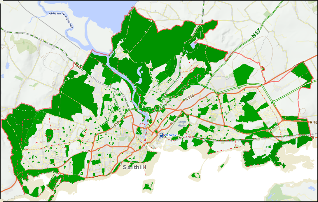
Figure 5.1 Green Network
Table 5.1 sets out the range of different spaces that make up the green network. They define and form the landscape of the city and a fifth of the total land area within the city boundary is comprised of green space, designated protected habitats, recreation and amenity open space and agricultural land.
Table 5.1 Open Spaces within the Green Network
|
Protected Spaces
|
|
Blue Spaces
|
|
Green Spaces
|
|
Community Spaces
|
|
Open Spaces
|
The green network includes a range of European, national and local sites of ecological importance that are important elements of the city’s landscape, forming part of an ecological network of corridors and stepping stones that allow for the movement of wildlife in the urban environment. The ecological sensitivity of open spaces varies and the Council will continue to ensure the conservation and protection of designated sites of ecological importance and habitats in the development of green network. Integrated into the green network is the range of blue spaces in the city which are significant natural resources comprising an extensive coastline, Lough Corrib, River Corrib, canals, streams and wetlands. Also integrated into the green network are community spaces which afford direct access to nature and recreation opportunities. Agricultural lands also contribute to the green network providing a natural backdrop to the city and supporting a diverse habitat.
The City Council’s Recreation and Amenity Needs Study (RANS) 2008 provided a co-ordinated framework for the planning and management of recreation facilities and activities within the city. It developed a hierarchy of open spaces which is set out in Table 5.2. In view of the growth strategy for the city and evolving amenity needs, the RANS is scheduled to be reviewed and updated in 2022 with a specific focus on a Green Space Strategy. The outcome of the strategy will be reviewed in order to assess if changes are required to the policies and objectives of this plan.
Table 5.2 Open spaces within the Green Network
|
Open Space Type |
Location |
Primary Purpose |
|
Three City Parks |
|
Large scale open spaces for passive and active recreation, wildlife conservation and education (over 10 hectares) |
|
Neighbourhood Parks |
Mixed sized parks located adjacent to residential areas e.g. Renmore Park, Cappagh Park, Mervue, McGrath’s Field (Knocknacarra), Ballinfoile Park, South Park, Shantalla. |
Parks formally designated for passive and active recreation (1-10 hectares) |
|
City Centre Parks |
Central city locations including Kennedy Park, Millennium Children’s Park, Riverside Walk, Fr. Burke Park, Celia Griffin Memorial Park and Woodquay |
Small scale parks designated for passive and active recreation, streetscape value and civic function (less than 1 hectare). |
|
Enclosed Marine/Wetland and Coastal Areas |
Sliverstrand to Roscam including Lough Rusheen, Lough Atalia, Ballyloughane Beach |
Naturally occurring environments used for passive and active recreation, bathing and shore fishing wildlife conservation and education. |
|
Rivers, Waterways and Lakes |
River Corrib, canal systems, Sandy River and Ballindooley Lough |
Open spaces adjacent to river and canal system or means of access to river and canal system offering townscape value, water based sporting opportunities, passive recreation, fishing and wildlife conservation. |
|
Civic Spaces |
Eyre Square, Fishmarket Square, Shop Street/Quay Street, Courthouse Square, Woodquay, The Small Crane |
Urban spaces composed of soft or hard landscape treatment or a combination of both, offering venues for civic events or passive recreation. |
|
Greenways |
Greenways including coastal, river, canal and woodland walk and cycle ways |
These are established or potential amenity corridors facilitating non-motorised travel along linear routes (including rights of way), often with wildlife corridor importance along coastal areas, through woodlands and parks, river or canal corridors. Recreation and alternative circulation routes for pedestrians and cyclists. |
|
Residential Open Space |
Open space in residential areas occur throughout the city |
Provides for general amenity, biodiversity, passive and active recreation in particular children’s play. In general all open space lands above 0.2 hectares. (1/2 acre) in residential areas are zoned RA Recreation and Amenity. |
|
Commercial and Industrial Open Spaces |
Throughout the city including IDA lands and St. James Health Centre |
Areas offering general amenity value often with landscape planting within the grounds of commercial or industrial developments. These areas can provide a setting for buildings and soften the visual impact of development and contribute to biodiversity. |
|
Institutional Open Space |
Throughout the city including NUIG and GMIT grounds and Merlin Park Hospital grounds |
These comprise of open space as part of educational, health, religious or residential institutional use, often with some access to the wider public. |
|
Cemeteries |
Throughout the city Including St. James Cemetery and Rahoon Cemetery |
Graveyard or burial ground, often located adjacent to a church or within a churchyard providing a green area within the heart of the community. |
|
Recreational and Amenity Zoned Lands |
Located at the fringes of the city including Ballybrit Racecourse, Dangan Woods, Roscam Woods and lands at Kingston |
Areas zoned recreational and amenity, which do not fall into any of the above categories. |
|
Agricultural Lands & High Amenity |
Throughout the city including land at Menlough Castle and woods and lands at Roscam |
Lands used for agriculture purposes, often forming greenbelt, offering amenity, passive recreation and visual aspect, contributing to biodiversit |
In the context of NPF growth targets for the city, the Council will continue to acquire lands zoned for recreation and amenity use or other lands with potential to enhance the quality of the green network, support connectivity, climate resilience and to provide additional sports and recreation facilities. Initiatives including the “Healthy Green Spaces”, “Green Flags for Parks” and “Greening of the Laneways” will be progressed in conjunction with local communities, schools and voluntary groups to enable the development of amenity spaces and support biodiversity. Opportunities for public/private partnerships will also be investigated where a high standard of recreation facility can be developed, including with public access.
The green network plays an important role in sport and physical activity. The ‘National Sports Policy 2018 – 2027’ and National Physical Activity Plan (2021) sets targets and actions for increasing participation in sport for all ages and abilities. Existing and proposed active recreation facilities such as playing pitches, MUGAs, ball walls, tennis courts and running tracks are important facilities located within the green network which contribute to healthier lifestyles and social and community interaction. The review of the RANS will inform additional requirements for such facilities.
The Galway Sports Partnership also has an important role in increasing participation in sport delivering programmes of activity, training and education opportunities and raising awareness. A range of clubs and leisure providers also help improve facilities and increase participation.
|
Policy 5.1 Green Network and Biodiversity |
|
|
|
|
|
|
|
|
|
|
|
|
|
|
|
|
|
|
|
|
|
|
|
|
5.3 Protected Spaces
The City has a diverse range of habitats and species of national and European importance which are protected by legislation. A key aspect of the plan is to ensure compliance with environmental legislation. Complementing this approach, the green network will seek to conserve and restore biodiversity, improve connectivity between habitats and reduce the effects of fragmentation which can lead to permanent loss of species.
5.3.1 European Designated Sites
The city supports a number of European designated sites and protected habitats, including Galway Bay Complex and Lough Corrib Special Areas of Conservation (SACs), designated under the EU Habitats Directive and the Inner Galway Bay and Lough Corrib Special Protection Area (SPAs), designated under the EU ‘Birds’ Directive. These areas host the natural habitat types listed in Annex I and habitats of the protected species listed in Annex II. They are part of the Natura 2000 network of ecologically important sites across the EU and they seek to conserve a range of sensitive habitats and species.
Proposed plans and projects should consider DEHLG Guidance for Planning Authorities on Appropriate Assessment of Plans and Projects in Ireland (2009) and potential impacts identified in the Natura Impact Report (NIR) of the City Development Plan relating to habitat loss and fragmentation, water quality, disturbance and in combination effects. The EU Habitats Directive promotes a hierarchy of avoidance/protection, mitigation and compensatory measures and is based on a precautionary approach. The Directive provides an auditing tool to help deliver sustainable development. It provides a case-by-case mechanism for recording the implications of development on a European site and its conservation objectives and facilitates the decision making process.
It is critical that there is continued protection and sensitive management of these sites, so that the sites’ intrinsic high ecological and biodiversity value is safeguarded and in some cases restored. The policies and objectives of the City Development Plan have been drafted taking cognisance of Article 6 of the Habitats Directive. All plans including lower tier plans and projects identified as having potential to impact on European Sites are required to adhere to the requirements of the Habitats Directive, to ensure no adverse impact on the integrity of European Sites.
Under current legislation any plan/project and any associated works, individually or in combination with other plans/projects are subject to Appropriate Assessment (AA) screening to ensure there are no likely significant effects on the integrity of any European Site and that the requirements of Article 6(3) and 6(4) of the EU Habitats Directive are fully satisfied. When a plan/project is likely to have a significant effect on a European Site or there is uncertainty with regard to effects, it shall be subject to an Appropriate Assessment. The plan/project will proceed only after it has been ascertained that it will not adversely affect the integrity of the site or where, in the absence of alternative solutions, the plan/project is deemed imperative for reasons of overriding public interest. The designated European conservation sites in the city are set out in table 5.3.
Table 5.3: European Sites in the City
|
Special Areas of Conservation (SAC) |
|
|
|
Special Protection Areas (SPA) |
|
|
5.3.2 National Designated Sites
Sites of national ecological importance are designated and protected under the Wildlife (Amendment) Act 2000. A Natural Heritage Area (NHA) is an area considered important by reason of its flora, fauna, habitat type and geological or geomorphological interest. Sections of Moycullen Bog NHA, (site code 002364), an extensive lowland blanket bog, are located east of Tonabrocky.
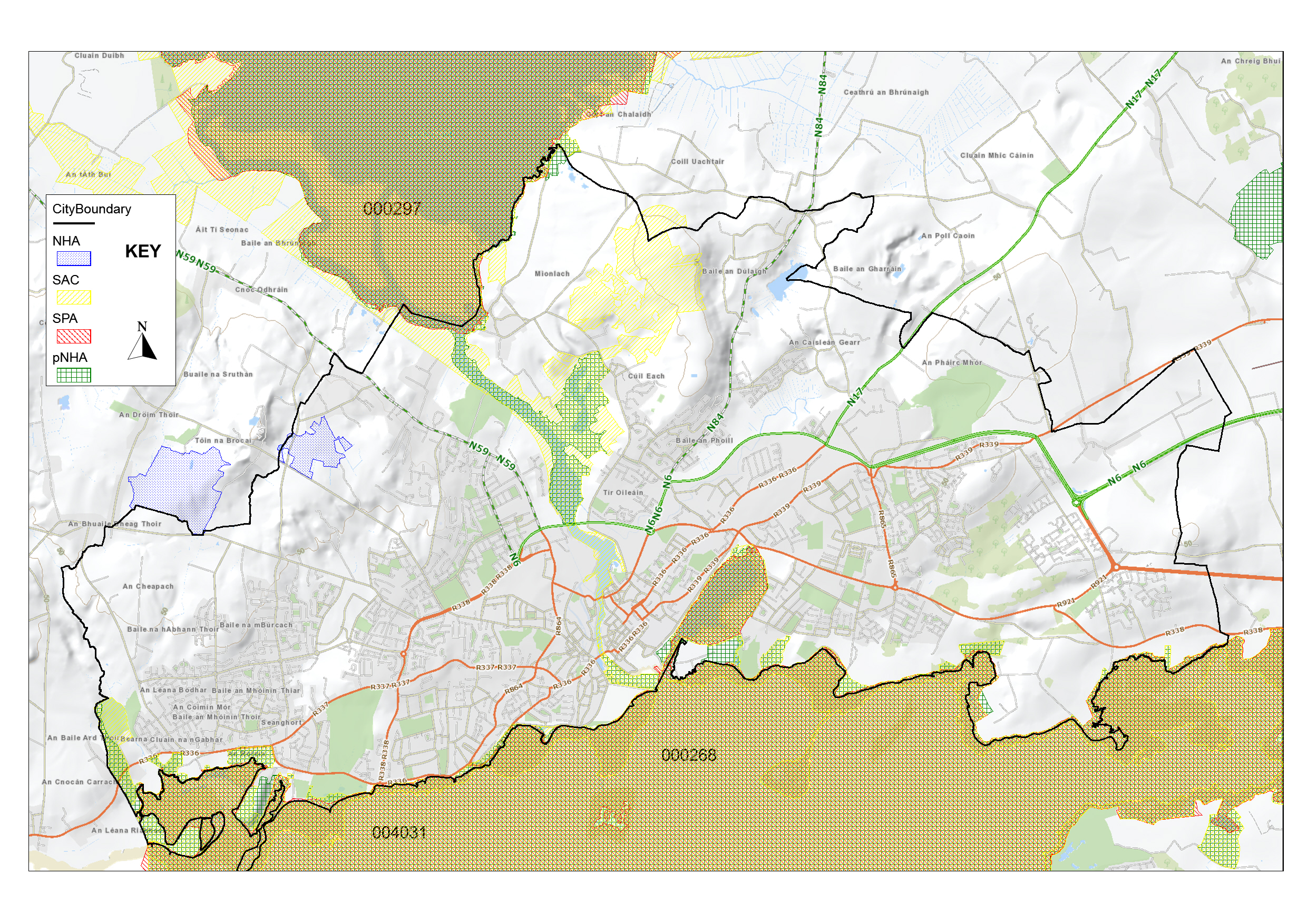 Figure 5.2 SACs, NHAs and pNHAs in the city
In addition, there are proposed NHA (pNHA) designations, for areas of that are known to be of importance for biodiversity but have not yet been fully evaluated. Two pNHAs are located in the city and these areas for the most part also have SAC status (see table 5.4).
|
Table 5.4: Natural Heritage Areas (NHA) and proposed NHAs (pNHA) in the city |
|
A number of sites of geological heritage importance have been identified by the Geological Survey of Ireland as part of a Geological Heritage Audit for Galway City completed in 2020 (see table 5.5). These are categorised as County Geological Sites (CGS) pending any further NHA designation by the NPWS.
|
Table 5.5 County Geological Sites (CGS) in the city |
|
|
|
There are also a range of habitats and species at locations outside of EU and national designated sites which are covered by legislative protection. These include species of flora and fauna and key habitats. Development proposals which are likely to impact on these species and/or habitats, will be required to carry out an Ecological Impact Assessment (EcIA) in order to assess the impact and where appropriate will be required to include for mitigation measures.
5.3.3 Local Biodiversity Sites
In addition to areas with European and national nature conservation designations, the city has a network of Local Biodiversity Areas which also have high nature conservation value. These Local Biodiversity Areas can be classified into a range of different habitats such as lakes, exposed limestone pavement, woodlands, wetlands and peatland, all making an important contribution to biodiversity and amenity within the city (see table 5.6). Article 10 of the EU Habitat’s Directive requires member states to protect those features of the landscape which provide linear features or stepping stones essential for the migration, dispersal and genetic exchange of wild species, through planning and development policies. Local Biodiversity Areas provide vital habitat for many species, provide important wildlife corridors and ecological stepping stones in the city and contribute to the ecological coherence of the network of European Sites. The Galway Biodiversity Action Plan 2014-2024 expanding on the original network identified in City Habitats Inventory 2005, identifies the River Corrib as a main wildlife corridor which provides a link between the coast and the rich mosaic of habitats in the city’s hinterland. The Biodiversity Action Plan proposes to resurvey and record the local biodiversity areas. It also seeks to identify any additional wildlife corridors and stepping stones which are of high value and merit in the green network.
Many of these areas are located on lands zoned for agriculture and recreation and amenity use and overlap with sites with nature conservation designations, which contribute to their continued conservation. The Council acknowledges that developments are likely within the vicinity of some of these Local Biodiversity Areas. A precautionary approach will be adopted and the Council will have due regard to the sensitivity and the biodiversity importance of these areas, where developments are proposed. Local Biodiversity Areas shall be taken into account in the planning, design and assessment of development applications and will inform local area plans, where appropriate.
The Council will include measures to encourage biodiversity and ecological stepping stones in developments, including open space provision, the retention of existing natural features such as trees, hedgerows, stone walls, native species planting, and the use of green design features such as green roofs, green walls and SuDS.
Table 5.6 Network of Local Biodiversity Areas
|
Description |
Details |
|
Rusheen Bay – Barna Woods – Illaunafamona |
A variety of habitats located around the intertidal area of Rusheen Bay including Barna Woods. The entire area is designated as either a SAC and/or SPA. Lough Rusheen is designated a Wildfowl Sanctuary under the Wildlife Acts 1976 & 2000. |
|
Cappagh – Ballymoneen |
An area of blanket bog, fen, wet grassland and scrub located between Cappagh and Ballymoneen Roads. |
|
Ballagh – Barnacranny Hill |
Connemara peatland, including blanket bog, fen, wet grassland, heathland and scrub, located east of Tonabrocky. This area is designated a NHA, Moycullen Bog NHA. |
|
Mutton Island and nearby shoreline |
Intertidal area is a designated SPA. |
|
Lough Atalia and Renmore Lagoon |
Lough Atalia and the intertidal area at Renmore, except the Renmore Lagoon, is designated a SPA. Lough Rusheen is designated a Wildfowl Sanctuary under the Wildlife Acts 1976 & 2000. |
|
River Corrib and adjoining wetlands |
The River Corrib and the associated wetlands is a designated SAC and a Salmonid River. |
|
Menlough – Coolough Hill |
Area includes oak-ash-hazel woodland at Menlo Woods and exposed limestone rock, calcareous grassland and small turlough. |
|
Ballindooley – Castlegar |
Area centred on Ballindooley Lough, includes fen, reed swamp, wet grassland, scrub and exposed limestone rock. The Castlegar area contains smaller areas of wet grassland, scrub and exposed limestone. |
|
Ballybrit Racecourse |
Large open area of species-rich calcareous grassland. |
|
Merlin Park Woods |
Mature broad-leaf trees, mixed broad-leaf / conifer woodlands. |
|
Doughiska |
Area of exposed limestone rock with calcareous grassland and scrub located along the eastern boundary of the city. The grassland contains orchid species and protected Small white orchid. |
|
Roscam |
Relatively undisturbed examples of salt marsh, shingle banks, brackish lagoon, sandy shore and muddy sand shore, with calcareous grassland and scrub. |
Table 5.7 Other Areas/Features of Local importance in the City
|
Description |
Details |
|
Terryland Forest Park |
Young urban forest of native broad-leaf trees and pockets of wetland vegetation located on both sides of Terryland/Sandy River. |
|
City Canal System |
Western part of the city and one artery to the east of the Corrib River at Newtownsmyth. |
|
Waterbody |
Small lake adjoining residential development on Headford Road. |
|
Cave, Merlin Park |
A limestone cave near railway bridge. |
|
Terryland Glenanail |
A small river flowing from the south-eastern corner of Lough Corrib. |
|
Cooper’s Cave Terryland |
Square bedding cave chamber located northeast of the Terryland River sink. |
5.4 Control of Invasive Alien Species
Invasive alien species are a significant threat to biodiversity impacting on native species and encroaching on habitats. Within the city there is evidence of invasive species spread in particular the Japanese Knotweed. Zebra mussel has also been found in the Corrib system. Legislative controls are in place under the EU (Birds and Natural Habitats) Regulations 2011 recognising the adverse impacts of these species on the environment and economy. The approach of the Council is to adopt invasive species management and control operations on public lands at a number of affected locations and to promote public awareness of the impacts of invasive alien species.
|
Policy 5.2 Protected Spaces: Sites of European, National and Local Ecological Importance |
|
|
|
|
|
|
|
|
|
|
|
|
|
|
|
5.5 Blue Spaces
Galway City has an unparalleled water environment with an extensive coastline, Lough Corrib, River Corrib, waterways and canals. These important natural resources which are termed ‘blue spaces’ in the plan contribute to health and wellbeing, support an attractive city environment, provide a diverse ecosystem and are a valuable recreation resource. These assets contribute significantly to the positive image of the city and have socio-economic value and recreation and amenity potential. However, any such recreation and amenity development must be balanced with the protection of the integrity of the environment. Greater and improved access to water bodies will be investigated in order to facilitate passive and active recreation. In general, water based recreation and ‘blueways’ which are multi activity routes on or alongside water will be supported where the environment, water quality and protected habitats are adequately protected.
5.5.1 Coast
Galway Bay and the Atlantic Ocean are an integral part of the identity and historic culture of the city. The links between the city and the sea are exhibited in its strong maritime history, its built form and the traditions of areas such as The Claddagh, Fishmarket, The Docks and Salthill. The impact of climate change with predicted sea level rise, greater frequency of storm surges and wave overtopping makes these areas vulnerable to flooding and coastal erosion. Measures to protect the city from flooding are currently being developed under the Coirib go Cósta Galway City Flood Relief Scheme.
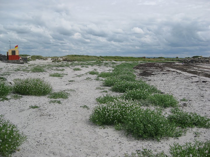
As well as being an important natural heritage resource, the coast is an important tourist, amenity and recreation resource. The beaches in the city are significant assets as designated bathing areas. Both Salthill and Silverstrand beaches also have Blue Flag status and received the Green Coast award in 2020 in recognition of the high quality environment of these areas. The Council will continue to enhance the range of facilities to support coastal amenity and recreation and will consider the potential restoration of the tidal pools in Salthill as a year round public amenity and recreation facility accessible to all.
The National Marine Planning Framework 2021 sets out the national objectives and maritime planning policies for activities in the marine area. The Maritime Area Bill 2021 will advance the designation and management of Marine Protection Areas and will support the protection of the marine environment when adopted. The Council will accord with any requirements for local authorities in the implementation of this legislation.
5.5.2 Rivers, Canals and Waterways
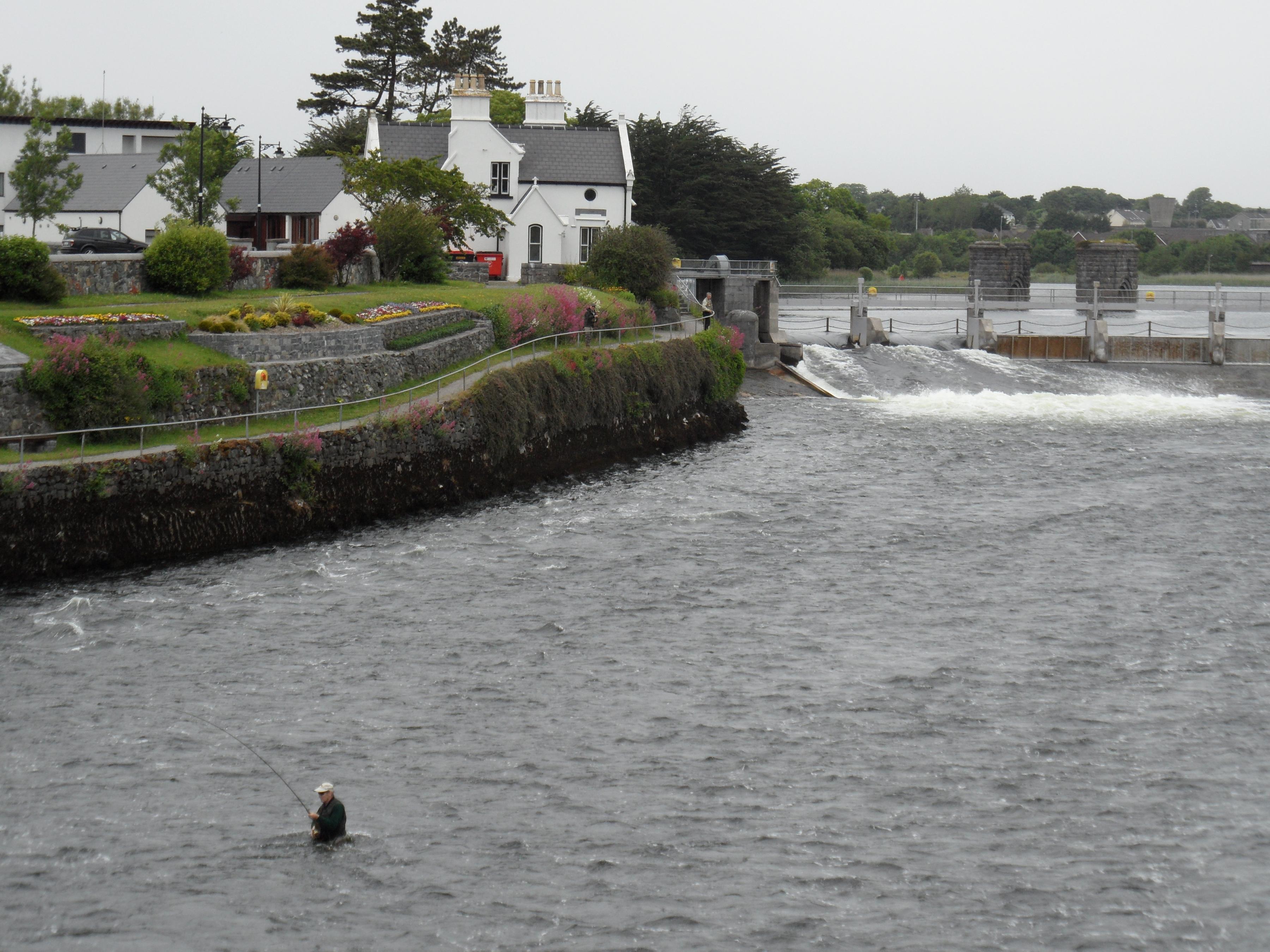
Rivers, canals and waterways including the River Corrib system, the Eglinton Canal, the lesser waterways of the Cathedral River, the West River and the many headraces, tailraces and minor canals give character and definition to the city. These areas support significant linear wildlife and biodiversity corridors within the urban environment providing connectivity to the wider city and hinterland. The River Corrib as well as being an SAC, pNHA and designated Salmonid River is also a significant recreation and amenity resource and a water supply source. These characteristics require a balanced approach supporting river conservation with appropriate use and public accessibility and facilitation of sustainable water based activities. Outside of the city centre the banks of the River Corrib are semi-natural in character and play an essential role in flood alleviation including in wetland and floodplain areas.
The canal system is an important architectural feature reflecting the industrial past and economic and physical evolution of the city. There is potential for exploring the capacity of the canal system for active recreation and to enhance biodiversity and ecological connectivity. Further examination of this resource to promote climate action may tap into initiatives such as micro hydro power generation. Public accessibility to the canal will be encouraged in the design of developments, where feasible. Special consideration is required to ensure any development abutting the canal does not disproportionately affect its setting, amenity and aesthetic quality. The flood risk associated with these waterways is also an important consideration and is currently being considered under the Coirib go Cósta Galway City Flood Relief Scheme.
These water resources can contribute to the development of “Blueways” which is a concept to expand tourism opportunities associated with waterways. The Council will seek to advance blueways in the city in the interests of both the tourist and resident population. In particular, the development of the Great Western Blueway on the River and Lough Corrib facilitating activities such as kayaking, canoeing, rowing, angling and boating in a sustainable manner has potential to enhance amenity and tourism in the city.
|
Policy 5.3 Blue Spaces: Coast, Canals and Waterways |
|
|
|
|
|
|
|
|
|
|
|
|
|
|
|
|
|
|
|
|
5.6 Green Spaces
Green spaces in the city include for a range of parks, public spaces and woodlands. Urban green spaces are an important resource for communities providing for passive and active recreation. Some of the larger city parks include protected sites which support important habitats and species. Green spaces also shape the identity of neighbourhoods and provide a sense of place. They can enhance people’s quality of life and support mental health and physical wellbeing and provide quiet space, space for social interaction and play space. They contribute to climate resilience through their effects on negating urban heat, offsetting greenhouse gas emissions and attenuating surface water.
The development of a hierarchy of parks in the city was established under the RANS (see figure 5.3). This recommended the preparation of parks masterplans with a particular emphasis on improving qualitative aspects of parks, promoting multifunctionality and taking into consideration the natural heritage value of each park. A number of these masterplans have been prepared and the Council will continue to progress implementation. The preparation of masterplans for the balance of parks will be progressed during the period of this plan.
Healthy Green Spaces (HGS) is a joint City Council and community initiative that aspires to improve the quality of green spaces in the city. The aim of the HGS is to ensure green spaces are attractive and safe, enhance biodiversity, support pollinators, climate adaptation, long term carbon sequestration and reduce waste. The initiative includes a commitment to eliminate the use of pesticides and harmful chemicals, utilise organic soil nutrition methods, adopt a zero waste strategy incorporating composting and grass cutting management. As a partner to the All-Ireland Pollinator Plan, the City Council implements measures that enhance pollination, these include No Mow initiatives in open spaces, pollinator friendly planting and native wildflower planting.
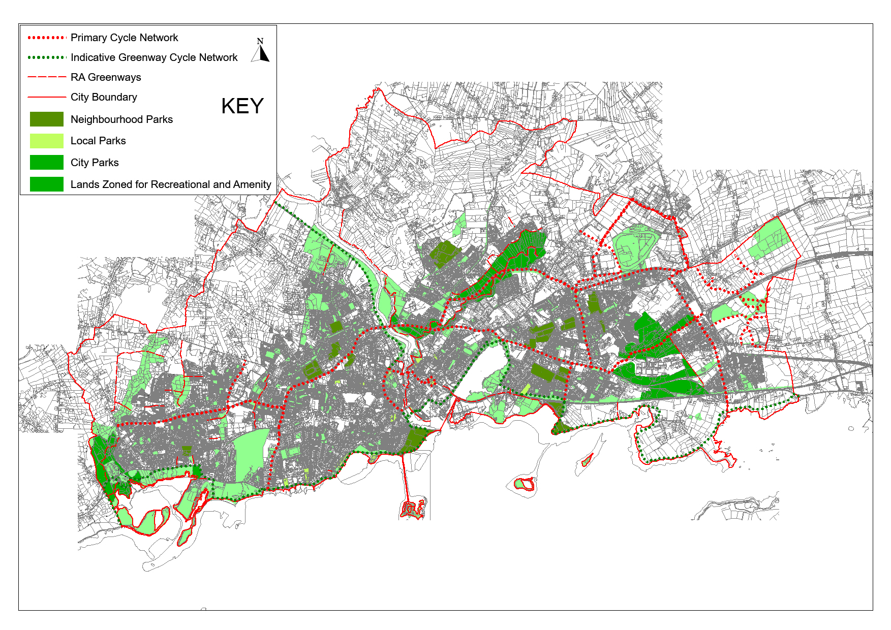 Figure 5.3: Hierarchy of Parks and in the city
Soil plays an important role including in food production, surface water drainage and flood management. It supports natural ecosystems and biodiversity and provides carbon storage. Soil is vulnerable to contamination, compaction and erosion by wind and water. Through the retention, enhancement and creation of areas of open space, community gardens/allotments, green infrastructure and biodiversity enhancement within the green network, the Council will encourage good soil structure and condition.
5.6.1 Urban Woodland Parks and Trees
Urban woodland parks and trees are important recreational amenities and natural features in the city. These natural assets contribute to the health and wellbeing of the community. Woodland and trees enhance the aesthetic quality of the landscape, provide valuable habitats for wildlife, contribute to carbon capture and storage, improve air quality and reduce the impact of noise. Woodlands, trees, stands of trees, and hedgerows form important ecological corridors and stepping stones enhancing biodiversity in the urban environment and need to be valued and protected. The Council will, where possible, protect trees, woodlands and hedgerows of special amenity or environmental value. The Council will work with stakeholders such as the Friends of Merlin Woods and the Terryland Forest Park committee to protect and enhance these valuable amenities within the city. A Tree Planting Strategy for the city which will provide for long term planting, protection and maintenance of trees, hedgerows and woodlands will be prepared. In advance of this, the Council will continue its tree planting programme, in particular, within public amenity areas. Tree planting will also be required within developments as part of an overall landscaping plan.
|
Policy 5.4 Green Spaces: Urban Woodlands and Trees |
|
|
|
|
5.7 Community Spaces
Elements of the green network provide valuable amenity and related healthy living and lifestyle benefits to the community. These ‘community spaces’ allow access to the natural environment, encourage social interaction and provide functional connections between other spaces and facilities. Community spaces include greenways, places for children to play, protected views of special amenity value and interest, allotments, community gardens and cemeteries.
5.7.1 Greenways, Boreens and Public Rights of Way
The plan sets out an integrated network of greenways in the city. Greenways are provided for through the GTS. These are routes segregated from the road and exclusively reserved for pedestrians and cyclists. In addition to these routes, the greenway network also includes for less formalised routes and trails which are provided within amenity areas and which may not have the same standard of accessibility. These greenways are more simple in design and can be integrated with nature to enhance recreation opportunities and support healthy and active living. They can also play an important role in nature conservation and enhance the ecological corridor network linking habitats, through sensitive location, design and maintenance. An integrated approach is necessary to incorporate appropriate surface materials and features such as hedgerows, grass verges, native wildflower species and stone walls which are integral landscape features along a greenway route. Appropriate maintenance and management is also necessary.
A number of greenway projects are proposed in the city some of which have the capacity to link in with the broader national greenway network. The Galway to Dublin Cycleway project is partially completed with the route selection for the Athlone to Galway section in progress. It will form part of the EuroVelo network of long-distance cycle trails in Europe. A greenway between Galway City and Clifden, the Connemara Greenway, is also in progress, which will traverse through the NUI Galway campus and onwards to Oughterard.
The plan acknowledges that in order to conserve and protect sensitive ecological areas, greenway routes may need to be restricted or redirected to less sensitive areas. In this regard, the routes of proposed greenways shown on accompanying Development Plan maps are indicative only. Proposed greenways will be subject to a route selection process, which will take cognisance of site-specific circumstances including consideration of ecological and environmental sensitivities. Such routes will only be developed within and adjacent to European Sites where it can be shown that there will be no adverse impacts upon the integrity of the sites as defined by their conservation objectives.
Within the city there are opportunities to enhance the network of boreens as a recreation and amenity resource. In collaboration with communities, the Council will support the use of this network to encourage healthy lifestyles and enhance connectivity.
There are also opportunities to improve permeability between and within neighbourhoods and local services and to make improvements to existing connections which are public rights of way. It is the policy of the Council to preserve existing public rights of way for the common good. The Council will seek to create new rights of way where necessary for pedestrian convenience or amenity reasons and also to enhance existing public rights of ways, where appropriate. Where in the interests of proper planning and sustainable development, the extinguishment of an existing right of way becomes expedient, the Council may require the provision of a suitable alternative. A compilation of an inventory of established rights of way in the city has commenced. In the interests of keeping this a dynamic project, it will be hosted on the Council website and will apply best practice approaches as highlighted in recent Office of the Planning Regulator (OPR) research.
|
Policy 5.5 Community Spaces: Greenways, Boreens and Public Rights of Way |
|
|
|
|
|
|
|
|
5.7.2 Child Friendly City
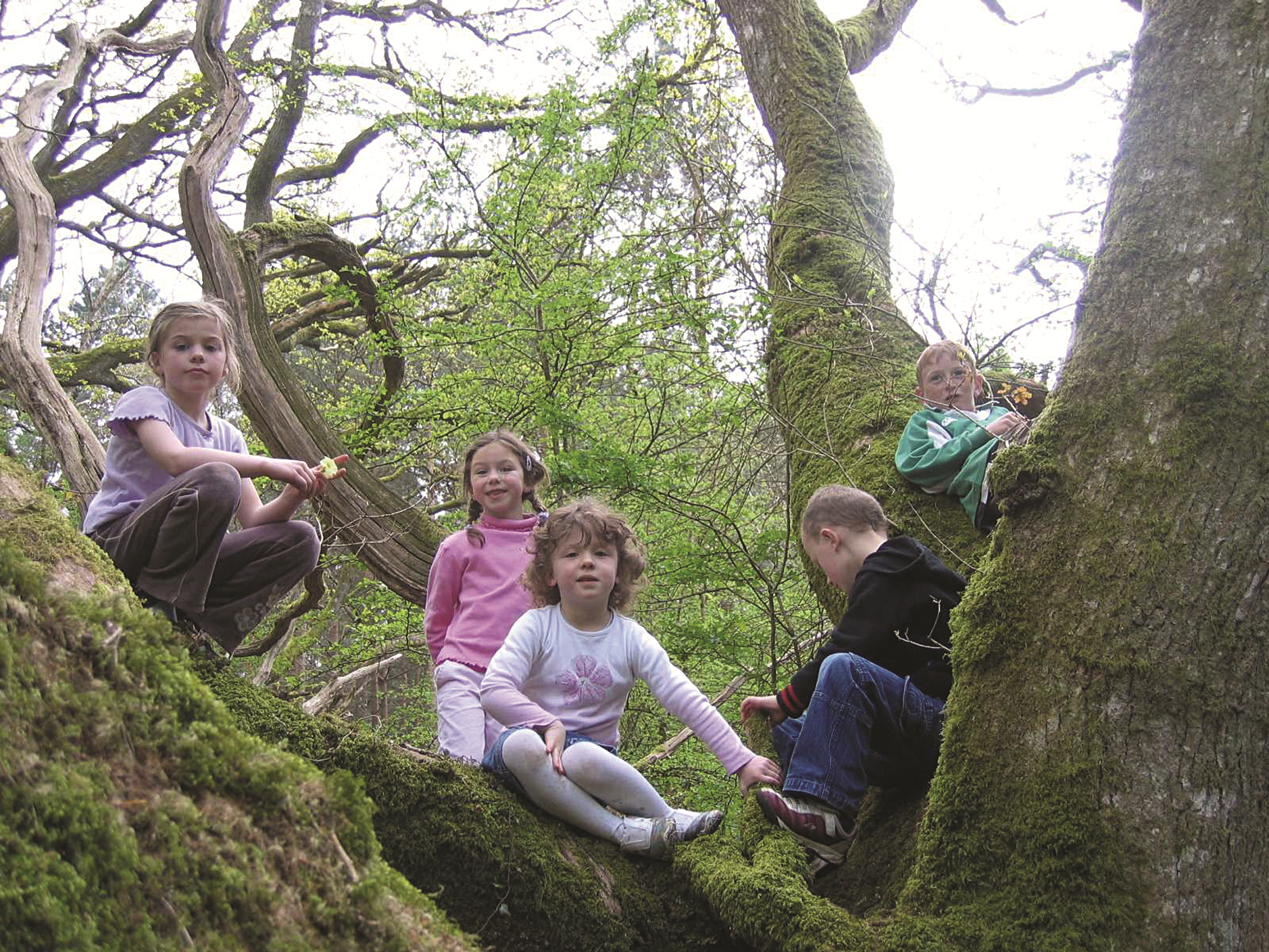
The concept of a Child Friendly City was developed in 2000 to consider the requirements of children and to promote safe streets and play areas, a good quality clean environment with green open spaces, and encourage the participation of children in cultural and social events as equal citizens of the city. The Galway as a Child Friendly City Report (2000) and subsequent policies in the RANS established a geographical and hierarchical approach to the provision of play areas in the city, from informal play areas and open spaces in residential areas to neighbourhood equipped play facilities. They informed the expansion of a network of playgrounds, skate parks, multi-use game areas and facilities for older/teenage children in the city. The Council support the right of the child to play through provision of inclusive natural and built play areas. Other measures which are included in this Development Plan, such as the development of home zones in order to provide a safe and quality living environment for play, traffic calming and the establishment of the concept of having safe routes to school which include initiatives such as ‘park and stride’ and school zones support a child friendly city.
|
Policy 5.6 Community Spaces: Child Friendly City |
|
|
|
|
|
5.7.3 Views of Special Amenity Value and Interest
There are views within the city’s landscape, which require special protection due to their distinctive scenic amenity, aesthetic or cultural value or historic setting. Views of scenic amenity value and interest define the character of the city, engender a strong sense of place and significantly enhance local amenities. Important views in the city include panoramic views which allow expansive views over scenic landscape, over the cityscape and key landmark buildings and linear views which are views towards a particular landscape, observed from a particular point. The enjoyment of protected views by the community and visitors is a key part of the experience of the city. It is acknowledged that views are not static and some changes in a view can be absorbed without visually depreciating the integrity of the view and in some cases make a positive contribution to the characteristics and composition of protected views, while other changes can have a negative impact reducing the experience of that view irreparably. It is the objective of the Council to assess proposed developments, which are located within the foreground, middle ground or background of a protected view, in the context of their scale, design and location.
Table 5.9: Protected views
Panoramic Protected Views |
|
| V.1 |
Panoramic views of the city and the River Corrib from Circular Road. |
| V.2 |
Views from Dyke Road and Coolagh Road encompassing the River Corrib and Coolagh fen. |
| V.3 |
Seascape views of Lough Atalia from Lough Atalia Road, College Road, Dublin Road and Lakeshore Drive. |
| V.4 |
Seascape views of Galway Bay from Grattan Road, Seapoint, the Salthill Promenade and the coast road to the western boundary of the golf course. |
| V.5 |
Seascape views encompassing Lough Rusheen including section of Blakes Hill, sections of Knocknacarra Road, sections of Barna Road from Knocknacarra to city boundary and including the road to Silverstrand Beach. |
| V.6 |
Panoramic views of the city, and the Terryland Valley from parts of the Castlegar-Ballindooley Road. |
| V.7 |
Views encompassing Lough Corrib from parts of the Quarry Road and Monument Road. |
| V.8 |
Seascape views of Galway Bay from the old Dublin Road to the city boundary. |
| V.9 |
Views towards the sea at Roscam. |
Panoramic Protected Views |
|
| V.1 |
Views from Galway-Moycullen Road (N59) of the River Corrib. |
| V.2 |
Views from Waterside of the River Corrib. |
| V.3 |
Seascape views of Galway Bay from Kingston Road. |
| V.4 |
Seascape views of Galway Bay at Ballyloughane from south of the railway bridge. |
| V.5 |
Views northwards encompassing the River Corrib and adjoining lands from Quincentenary Bridge. |
| V.6 |
Views towards Galway Bay from Hawthorn Drive, Renmore. |
| V.7 |
Views from Quincentenary Bridge Road southwards over Terryland Forest Park and River Corrib. |
| V.8 |
Seascape views from Military Walk, Renmore. |
| V.9 |
Views towards River Corrib from junction of St. Bridget’s Place with St. Bridget’s Terrace. |
| V.10 |
Views encompassing Ballindooley Lough from parts of the Headford Road. |
|
Policy 5.7 Community Spaces: Protected Views of Special Amenity Value and Interest |
|
|
5.7.4 Allotments, Community Gardens and Cemeteries
Allotments and community gardens are acceptable on a number of land use zones. They support biodiversity and encourage self-sufficiency, healthy living and create spaces that help bring communities together. Community spaces also include cemeteries, which provide important places for quiet contemplation in the city’s environment, and often support biodiversity and cultural heritage. In view of the diminishing capacity of existing cemeteries and in order to align with targets for growth, the Council will progress the identification and development of a suitable cemetery site to serve the city.
|
Policy 5.8 Community Spaces: Allotments, Community Gardens and Cemeteries |
|
|
5.8 Open Spaces
Open spaces in the city include urban open spaces, residential, commercial and industrial open space, institutional open space, recreation and amenity zoned lands and agricultural and high amenity lands. These spaces are important elements in the public realm of the city and play a vital role in defining the image of the city by affecting the perception of an area and fostering a sense of place. These spaces and their settings within the urban landscape make locations attractive to inward investment and business. They also contribute towards climate resilience and enhance the biodiversity of the city’s environment. The function of these open spaces vary throughout the city, many are meeting and gathering places, providing spaces for social interaction and events, while other open spaces have a passive and active recreation role. Many civic and urban spaces in the city, such as Eyre Square and Fishmarket, have an important cultural and historical legacy. Given the multi-functional aspect of these open spaces, many policies in other sections of this Plan inform the development and management of established and new open spaces within the green network. Also the Galway Public Realm Strategy gives comprehensive policy and guidance in this regard and a number of key projects to create new spaces and rejuvenate existing spaces integrated with the GTS, will be advanced during the plan period supplemented with URDF funding.
|
Policy 5.9 Open Spaces: Public Realm |
|
5.9 Agricultural Lands
Agricultural lands provide for agricultural uses and food production. They also have an important recreation, amenity and biodiversity value and can support climate adaptation and mitigation through application of nature based solutions and acting as carbon sinks and flood plains. They also form part of the unique natural setting, which provides a backdrop to the built environment and perform the function of a green belt. They can also facilitate strategic projects where impact on the community can be minimised. In the long term they can also function as a resource for the future strategic expansion of the city.
Agricultural lands come under two zoning categories in the plan – Agricultural Areas A and G. The G zoning objective are lands, that in addition to agricultural uses have an important landscape and aesthetic value, which distinguishes them from less visually sensitive A zoned agricultural lands. Development in the G land use zone is more restrictive than in the A land use zone. The policy of the Council for agricultural zones is to facilitate the continued use of these lands for agricultural purposes and limited development, subject to the protection of designated ecological sites, environmental considerations and to control non-agricultural development.
A limited type of residential development may be considered in areas zoned A. However, unless a convincing case of need is established, consent for dwellings will not be considered except to the immediate members of families (i.e. sons and daughters, grandchildren, nieces and nephews) of persons who are householders and residing in the immediate area and to farmers and the immediate members of their families. In all cases conditions on a grant of permission may be applied regarding initial occupancy. Such residential developments will not be open for consideration where suitable alternative sites are in the control of applicants or their immediate family and available on lands zoned for development within the City Council area. Standards for such developments are outlined in Chapter 11, Section 11.12. Outdoor recreation with small scale associated structures may be allowed in A and G zoned lands, but only where suitable alternative sites are not available on lands zoned for development within the city. In these areas, where structures are permitted, the sensitivity of the landscape and the quality of the environment should be reflected in both siting and design.
|
Policy 5.10 Open Spaces: Agricultural Lands |
|
|
|
|
|
Section 5.10 Specific Objectives
|
Specific Objectives |
|
Blue Spaces |
Short Term |
|
|
|
Medium/Long Term |
|
|
|
Green Spaces |
Short Term |
|
|
|
|
|
|
Medium/Long Term |
|
|
|
|
Community Spaces |
Short Term |
|
|
|
|
|
|
|
|
|
|
|
|
|
|
Medium/Long Term |
|
|
|
|
|
|
|
|
|
|
Open Spaces |
Short Term |
|
|
|
Medium/Long Term |
|
|
Contents
Observations
Observations
Green Network + Biodiversity
GEN submits that in preparing the GCDP 2023-2029 Galway City Council must acknowledge
and accept in the GCDP 2023-2029 that:
Biodiversity Loss presents an existential threat at least...
Natural Heritage, Recreation and Amenity
Recommendation:
Galway City Council should aspire to achieving National Park City designation for Galway as soon as possible
Skateboarding in Galway
The reason I am writing this letter is in relation to the skate situation in Galway. I as a skater would like to see more suitable environments for people to skate in e.g., skateparks. I would ask...
Green Spaces
Green Spaces: Quincentennial Park, Salthill Park and Toft Park should be maintained as open green spaces and should not have any additional built infrastructure installed. These spaces...