There is too much reliance on developer-led planning. Developers are required to prepare masterplans. Framework plans, spatial frameworks for a whole range of regeneration and opportunity sites where...
Chapter 10: Compact Growth and Regeneration
Closed28 Feb, 2022, 9:00am - 13 Apr, 2022, 11:59pm

10.1 Context
Galway City has in the recent past experienced rapid growth and economic success which makes it well placed with the additional targeted growth to become a city of scale. In line with the vision in the National Planning Framework (NPF) this growth needs to be managed so that development is more concentrated, compact and co-ordinated, enabling regeneration and rejuvenation that can support sustainability, climate action objectives and liveability factors.
The NPF recognises that the city can grow though building on its key strengths which includes a diverse population, a strong third level education sector, a world class med-tech cluster, a vibrant arts and culture scene, and an attractive setting. The RSES also identifies the City and Metropolitan Area as the primary driver in strengthening the development of the region and reflects the ambition to grow the city as a globally competitive, successful city and metropolitan area which can contribute to re-balancing growth nationally to achieve more regional parity and viable alternatives to Dublin.
Both national and regional frameworks require that future growth supports the principles of sustainability and placemaking and achieves a compact urban. In particular, a focus on regeneration of brownfield and underutilised sites that are well served by existing and planned public transport, amenity,social and community infrastructure is required. The potential for development of such sites for a range of uses including for new homes and employment opportunities ensures a more efficient use of urban land, optimises public investment and can act as a catalyst for wider development. These areas need to be targeted in a dynamic and responsive way to deal with both existing and emerging issues through policies and strategies supported in the Plan. The resulting regeneration will have potential to be transformative for the city, creating new urban districts, vibrant and attractive places, sustainable city living and a reduced carbon footprint.
The city centre is at the heart of the city and is the primary commercial and employment hub serving the city and wider region. It supports a high quality environment and historic core and hosts a strong arts and cultural heritage. The importance of the city centre requires policies to strengthen its role and to ensure that the assets which make it attractive are retained. There are other areas of the city which require a particular policy focus by virtue of their character and function, these include Salthill, Westside and Ardaun and the areas subject to Local Area Plans.
10.2 City Centre
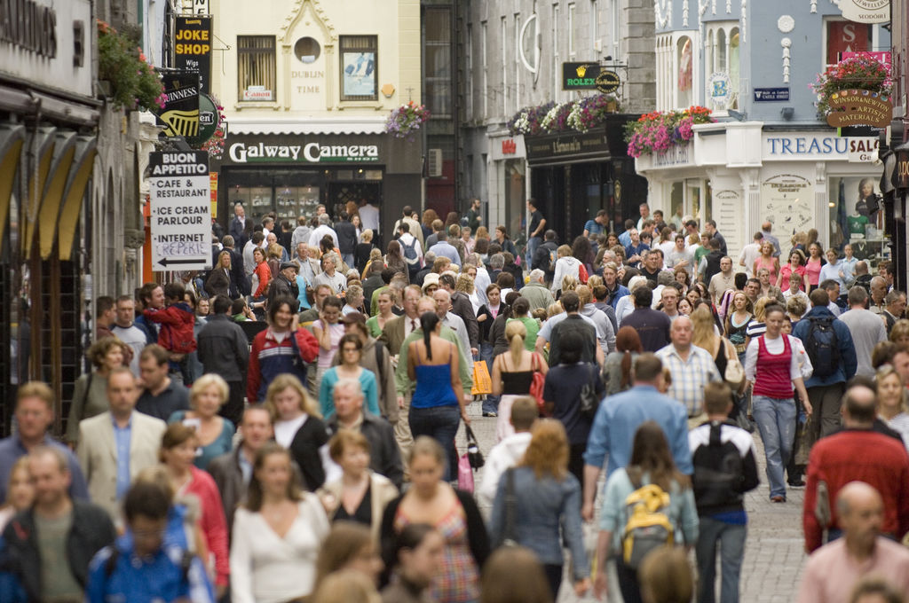
The City Centre area is particularly important, as it reflects to a large extent the unique and vibrant image of Galway, with an attractive historic core, a waterfront setting, a high quality environment and a good network of streets and spaces. It is the commercial and cultural heart of the city and the most importance focus for community and civic participation. It also supports a range of public and culture facilities, city living, employment, education and hospitality serving a catchment that extends well beyond the City and Metropolitan Area.
The national and regional ambition is for Galway to be a strong regional city with a focus on growth directed to the urban core. This presents an opportunity to further strengthen the role of the city centre and build on the assets that make the city centre an attractive location for investment and as a place to live and work and as a destination. This approach also supports the direction of planned public investment in sustainable transport measures outlined in the GTS to improve connectivity and accessibility and the quality of the environment in the city centre. Commitments in investment will support transformational Public Realm Strategy (PRS) projects, cultural, community and tourist facilities including the extension to the Galway City Museum and the Corrib go Cósta Galway City Flood Relief Scheme.
Figure 10.1 City Centre
The direction set out in the RSES and MASP is for a strong policy focus to enhance the city centre as the primary commercial area, supporting a regional role for a range of retail, commercial, tourism, social and cultural activities. Recognising that there are significant challenges facing city centres with changing retail trends, planning policy reflects the need for a diversity of uses and to move towards a broader day and night-time economy, which adds to the experience of the city centre and stimulates business and innovation, creativity and learning. It is recognised that initiatives such as the development of the Latin Quarter branding and securing the Purple Flag Award for excellence in managing the evening and night-time economy are important in the city centre, reflecting the image of the city as an attractive and safe destination. These measures will be further enhanced through urban greening, application of clean energies and use of smart technology adding to a “smart, green and clean” city centre.
The policy approach for the city centre is integrated in a number of chapters in recognition of its importance as the prime commercial, retail and employment hub, and by virtue of its range of characteristics including the high quality built environment, natural heritage assets, public realm and street and pedestrian network. The application of sustainability permeates this approach where the expansion of neighbourhoods in the City Centre offsets the need to travel and adds to a living city centre. New neighbourhoods will be encouraged through regeneration and through reuse of vacant/underutilised building stock.
Expansion of the city centre into key regeneration sites at Ceannt Quarter, Inner Harbour and Dyke/Headford Road will add to the vitality and viability of the city centre. These sites represent transformative opportunities for developments of scale with new residential communities and mixed uses complementing the experience of the city centre. They have potential to be developed in a sustainable manner while retaining the historic character and distinctiveness of the city centre. Regeneration opportunities in Nun’s Island, allied to NUI Galway property, also have potential to realise the development of uses which will enhance the attraction of the city centre, in particular for innovation, education and tourism.
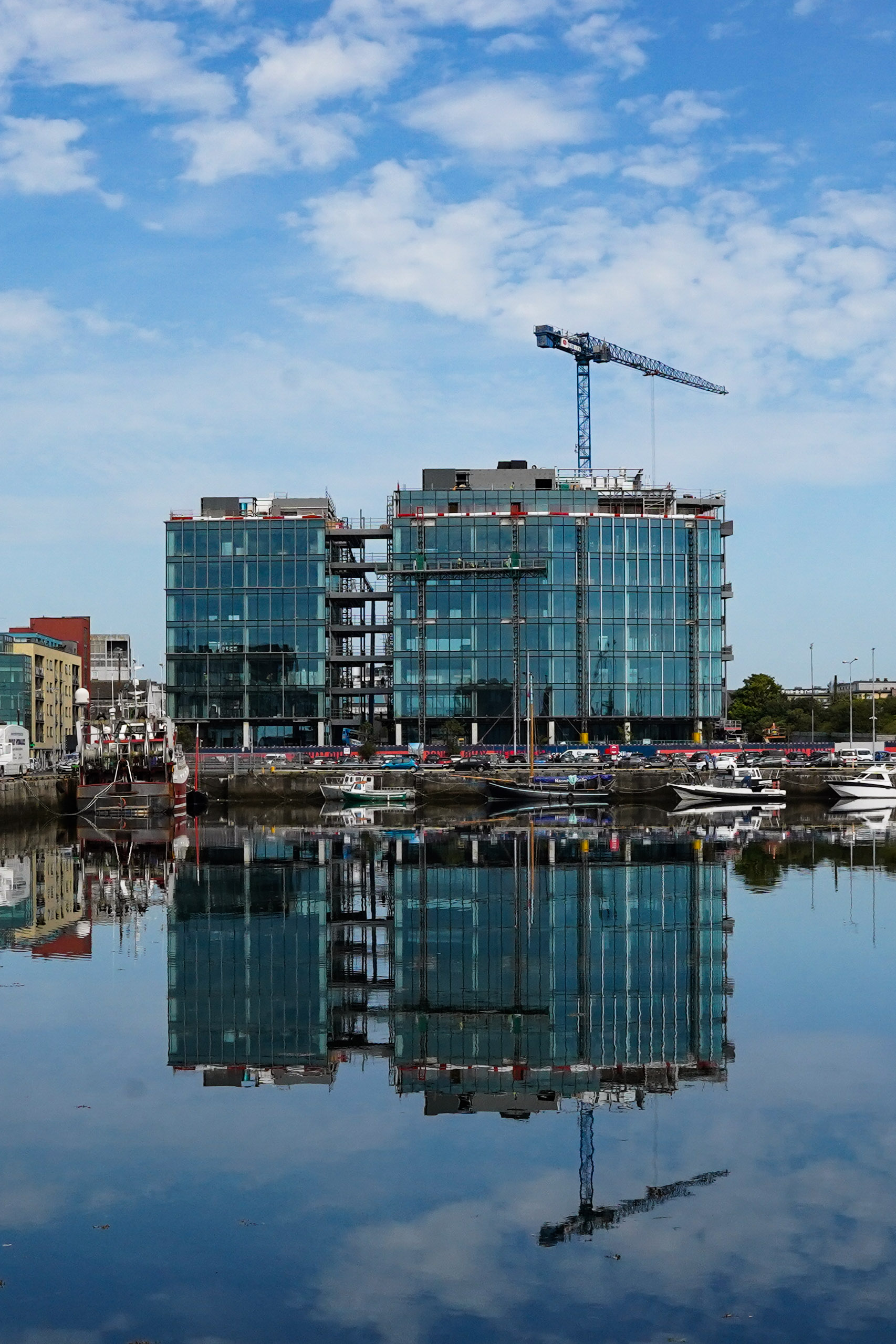
The development of key regeneration sites such as that at Ceannt Quarter and in the longer term at Headford Road, will complement the commercial offer in the city centre, in particular accommodating the larger retail floorplates which cannot be readily accommodated in the historic core. It will also support current trends towards city central locations for high tech office workspace and complements current projects in Galway City Centre such as the Bonham Quay development and the new Metlife Global Technology Campus at Augustine Street. The Bonham Quay development currently under construction will add significantly to the quantum of office space in the city centre and with a considerable future workforce will support the viability of other city centre uses. Other key city centre developments including a number of innovation hubs reflect the attractiveness of the city centre for such uses. Regeneration in the city centre will not only increase the economic viability of the city, it will also result in new liveable vibrant places which encourage diversity and inclusivity.
|
Policy 10.1 City Centre |
|
|
|
|
|
|
|
|
|
|
|
|
|
|
|
|
|
10.3 Regeneration and Opportunity Sites
A key sustainability element of national and regional policy is to deliver growth in a compact form with a focus on redevelopment of regeneration/brownfield sites and development of infill sites and underutilised land. A particular focus includes where these sites are integrated with the existing built footprint, are proximate to existing neighbourhood and employment areas, services and community facilities and where they are well served by existing and planned public transport and walking and cycling networks. A number of Regeneration and Opportunity Sites have been identified in the Core Strategy as having a capacity to accommodate growth, within the plan period and into the longer term. These sites can support a compact form and have potential for transformative redevelopment. They can support a mix of uses including a capacity for affordable housing in high quality living environments, where they can add vitality to the city centre, existing neighbourhoods and commercial centres. The council will investigate all options to progress the redevelopment of strategic Regeneration and Opportunity Sites in the city, including through URDF and other funding opportunities, through suitable partnerships, by direct land acquisition, through provision of enabling infrastructure and through implementation of city council plans and strategies.
10.4 City Centre Regeneration
A rich medieval period has left a strong legacy that gives definition to the city centre. However this tight network of streets has also served to constrain the direction of growth in recent years and limited the ability of the city centre to respond to demand for an increase in commercial floor area space. The sites at both Ceannt Quarter and the Inner Harbour present scope for a significant extension of the city centre and a re-engagement with the seafront. Similarly the area along the Headford Road adjacent to the city centre presents opportunities for regeneration through redevelopment of underutilised surface car parking and low density retail park formats to complement its central location, good accessibility and proximity to assets such as the River Corrib and Terryland Forest Park. The regeneration of these specific sites are considered in the NPF to be a key enabler that can facilitate Galway to grow to a city of scale.
These sites have potential to create their own character and sense of place but with reference and appropriate linkage, both in movement and design, to the greater context of the city. Within these areas a strong identity will be encouraged through innovative, good and contemporary architecture, good street network and high quality public realm. The current development of Bonham Quay is an example of modern city centre redevelopment that is creating new public realm, a strong urban spatial structure and engagement with the waterfront and achieving a high level of sustainability. Other Regeneration and Opportunity Sites at Eyre Square East, Nun’s Island area and on Henry Street also provide additional opportunities for regeneration including for reuse and adaptation of existing building stock which can support residential, educational and other uses.
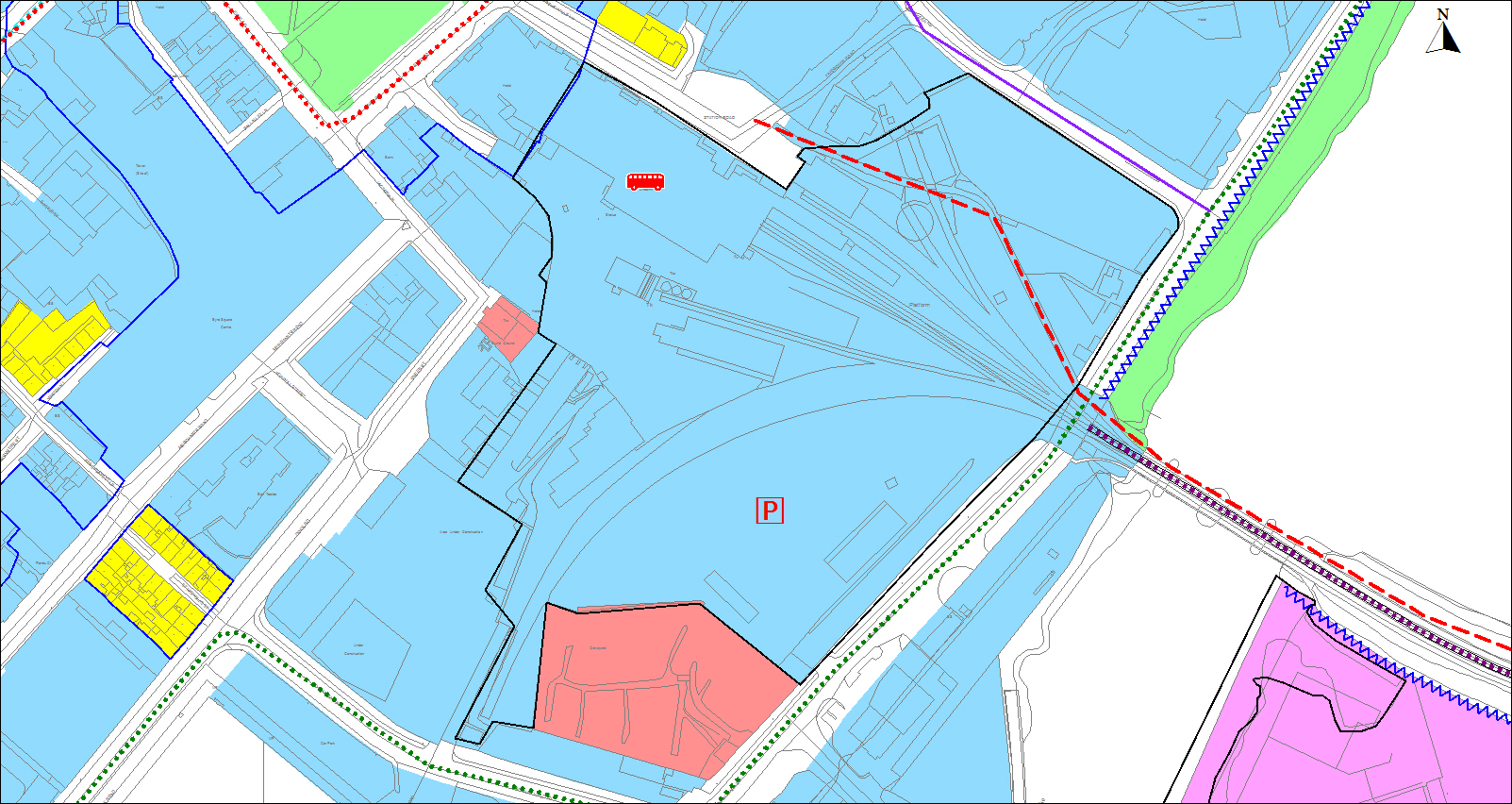
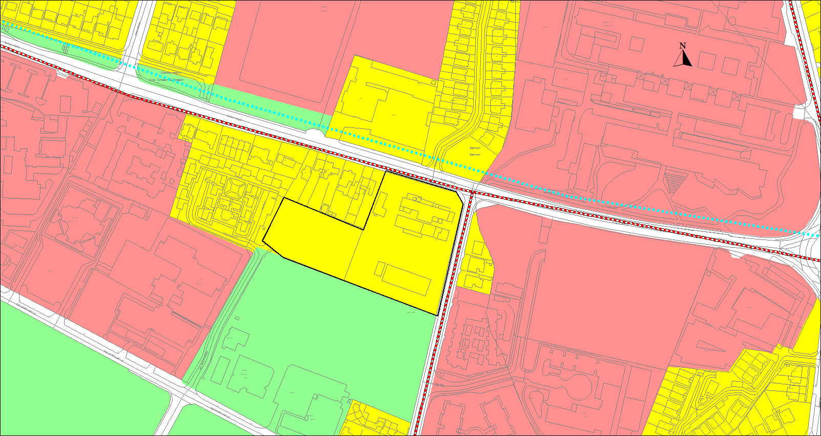
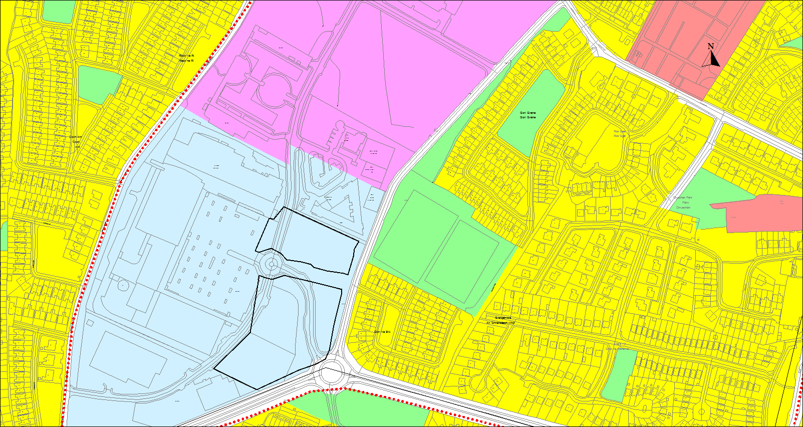
10.5 Ceannt Quarter Regeneration Site
The brownfield lands within Ceannt Station, measuring approximately 5.8 hectares has the potential for redevelopment of a transformative scale for the city. It represents an opportunity for modernisation and expansion of the public transportation function of the station, expansion of city centre retail and commercial, new residential development and a network of streets and public spaces replacing the redundant industrial uses. A key priority is to enhance the role of Ceannt Station as a multi-modal public transport interchange. Significant funding has been awarded under the URDF to upgrade and improve transport facilities and to provide capacity for future growth as targeted under the NPF.
Figure 10.2 Ceannt Quarter Regeneration Site
A significant portion of the site is deemed to be surplus to the public transport function and represents an opportunity for development of uses which are appropriate to a city centre. In advance of specific proposals for redevelopment, a masterplan will be prepared for the overall site and will be required to undertake the following:- Set out a vision for the area and show compliance with the development plan and city council plans and strategies including the Galway Transport Strategy, Public Realm Strategy, Urban Density and Building Height study, Heritage Plan, Biodiversity Action Plan and any future plans and strategies such as the Greenspace Strategy and Retail Strategy and emerging new LECP.
- In the context of the designation of Galway as a Regional City under the NPF, prepare an analysis of future likely and desirable needs for multi-modal transport facilities including for intercity and commuter bus and rail services. This should demonstrate how the dedication of land on the site for commercial development will not inhibit future demand for intensification of rail/bus or any other likely forms of public transport. Redevelopment will be required to accommodate and front-load a significantly upgraded transportation interchange with associated minimum amount of car parking and cycle parking facilities.
- Include for contextual analysis which demonstrates the link with the existing built heritage and historic city centre core to ensure that proposed developments can knit seamlessly into the fabric of the medieval core and reflect the existing urban grain. It shall reflect the cultural context and show how the unique waterfront setting can be celebrated.
- Include for character analysis detailing the rich historical and architectural heritage of the site and opportunities for the re-use and the re-establishment of relationships between these structures which shall be explored in the design and layout.
- Provide detailed proposals for buildings including height, scale and massing and demonstrate how existing important views, vistas and landmarks are respected and how such buildings contribute to aspects of urban design such as accessibility, enclosure, character, permeability and adaptability.
- Include for a maximum plot ratio for CC zones of 2:1. Consideration for a higher plot ratio will be given to development proposals in excess of the normally permissible plot ratio where such proposals would contribute to sustainability, architectural quality, urban design, public realm, delivery of housing and would make a significant contribution to urban character. This excess will be interpreted as a proportional increase only and will be assessed on performance based outcomes and general standards.
- Provide detailed proposals for good public realm that achieves a strong sense of place, good permeability and reflects a defined functionality and strong landscape impact. This element should demonstrate how linkage with existing spaces can be achieved and where continuity with likely scenarios on the adjoining sites can be made.
- Demonstrate how connectivity will be achieved identifying movement patterns and connections into the existing street network and opportunities for linkage and continuity in the design and layout of adjacent sites. This will be particularly important with regard to the adjoining Inner Harbour area where regeneration is also planned and where maximum advantage of the seafront location can be delivered.
- Include measures to support environmental sustainability and climate action including sustainable building design, green infrastructure and SuDs and the associated long term operation and management of these.
- Include measures to ensure connections to the green network and ensure biodiversity gain within the site.
- Include measures to demonstrate maximum public access and permeability throughout the site, give linkage and views to the seafront and Lough Atalia.
- Detail the type, quantum and distribution of uses. The use mix shall provide for a minimum residential content on the site equivalent to 30% of the proposed gross floor area, in order to achieve a significant level of residential presence and a critical mass to create a new community. In certain limited cases, where a proposal on a portion of the overall site, where residential content would not represent the optimum use for this specific site within the overall plan area, or where a specific development proposal might not in terms of urban design have a more beneficial use mix, the equivalent 30% requirement may be provided for at a more appropriate location within the overall site or as part of a different development. Any alternative measures to achieve the minimum residential content will be required to be part of the framework strategy for the overall development of the area. The commercial use mix shall include for both retail and modern office floorplates.
- Include the provision of an arts/cultural facility at the developer's expense and with a management regime incorporated into the development delivery that enables the long term sustainable use of such a facility.
- Take cognisance of the proximity of the Seveso III site in the Harbour Enterprise Park.
- Include a delivery strategy and phasing programme which demonstrates delivery of public benefits corresponding with each stage of construction such as a public square/cultural facility. The phasing programme should also be so designed that it is sensitive to market changes and that development for each phase can be, as far as is feasible, completed to a level that is self-contained and will not result in a negative visual impact on any publicly exposed area for a prolonged period.
- Include economic and investment strategies which will include for the role of all agency involvement in the delivery of services and infrastructure to be clarified.
The preparation of a Masterplan will be primarily the responsibility of the prime stakeholder but a significant level of engagement with the Planning Authority, the public, adjoining landowners and other stakeholders will be required to be demonstrated as part of the process. The Masterplan will build on the acknowledged co-operation existing between Ceannt Station landowners and the Port of Galway which includes for a common objective to have a co-ordinated and integrated approach embedded into future proposals.
As part of the phasing programme consideration will be given to the identification of an initial phase comprising of lands north of the railway line and fronting onto Fairgreen Road. These lands have the advantage of street frontage, direct accessibility, capacity to complete and further animate this streetscape. These lands are segregated from the lands associated with the function of Ceannt Station but regardless will be required to show how re-development will not inhibit future demand for intensification of rail/bus or any other likely forms of public transport and also how the development will contribute to the upgrading of existing transportation services. In advance of any proposal, these lands will be the subject of a Transport Requirement Study, to be carried out by Iarnród Eireann. This study which is being funded under the URDF will consider the potential to integrate transport within a multi-use development, with the objective to enhance the transport interchange.
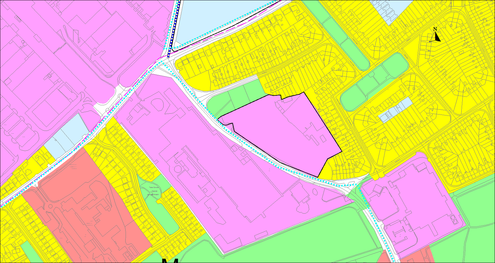
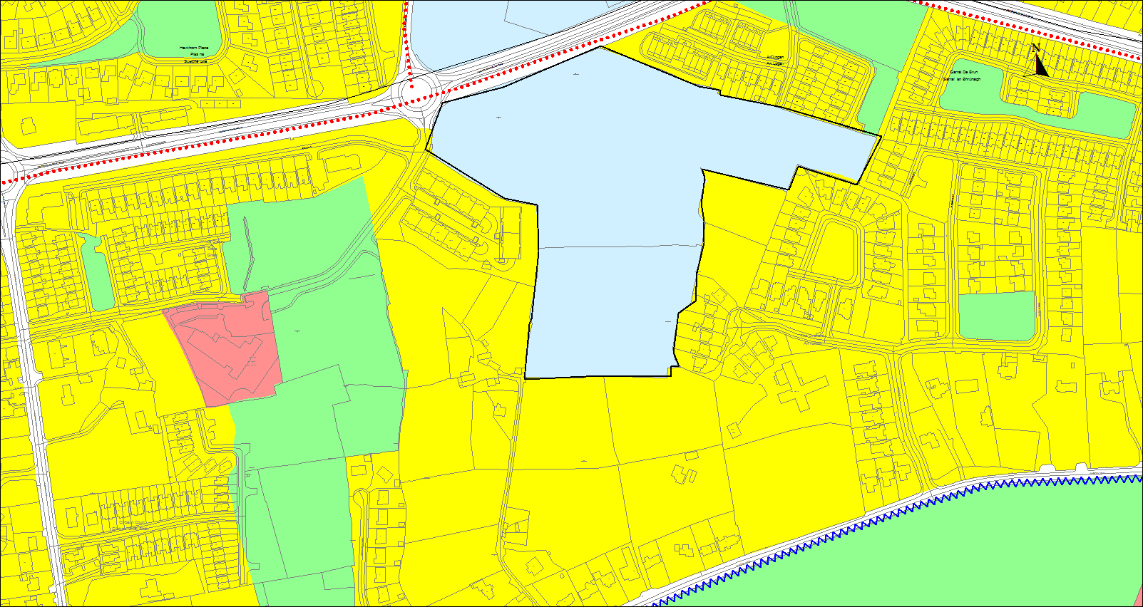
10.6 Inner Harbour Regeneration Site
The Inner Harbour Regeneration Site comprises approximately 7 hectares. It has potential for significant redevelopment providing an opportunity to re-establish links between the city centre and the sea, to create a high quality waterfront setting, a new city centre mixed use neighbourhood and include for water-related leisure uses. This area is already under transition with the current development of Bonham Quay contributing to the transformation of this part of the city centre and indicating a scale and density that could be achieved in the wider Inner Harbour. Control of the land is also changed with the transfer of the harbour shareholding to Galway City Council in 2020 who is now a significant stakeholder.

Figure 10.3 Inner Harbour Regeneration Site
It is acknowledged that the constraints associated with the existing docks require that in order to modernise and address deficiencies, the harbour functions will need to be relocated to an alternative site. Galway Harbour Company has proposals to address this by providing for a major new port development to the east of the existing Inner Harbour and a Strategic Infrastructure Development application for this proposed development is being assessed by An Bord Pleanála. The development of new port facilities has the potential to free up the existing working port site for redevelopment. These lands, in addition to other adjoining brownfield lands as defined in Figure 10.3, represent the definition of the Inner Harbour Area and the lands which would benefit from the preparation of a Masterplan.It is acknowledged that collaboration with stakeholders and significant public engagement has been carried out by the Galway Harbour Company with regard to the vision for the Inner Harbour. This has culminated in the preparation of a Draft Harbour Planning Framework which will assist the Galway Harbour Company in advancing options for redevelopment of this area. In principle the proposals for a mix of uses on these lands complemented by a unique waterfront setting linked to the city centre is acceptable and welcome. It represents a chance to enhance the experience of this area for both visitors and locals. It has potential to reveal the past trading history of the city and celebrate a high quality coastal edge linked to the city centre. In particular, it has potential to accommodate housing in the context of local need, national compact growth agenda and strategy for housing in Housing for All.
In view of this, the Council will consider the redevelopment of these lands where it can be demonstrated that a number of requirements can be satisfied. In advance of specific proposals for development, a Masterplan will be prepared for the overall site and will be required to undertake the following:
- Set out a vision for the area and show compliance with the development plan and city council plans and strategies including the Galway Transport Strategy, Public Realm Strategy, Urban Density and Building Height Study, Heritage Plan, Biodiversity Action Plan and any future plans and strategies such as the Greenspace Strategy and Retail Strategy and emerging new LECP.
- Address critical issues including sustainability, urban design context, maximum building heights, massing, appropriate use mixes and high quality public realm.
- Ensure that opportunities for water–based recreational facilities are maximised and that public access is secured throughout the area and along the waterfront.
- Ensure a high quality urban design, and demonstrate how redevelopment can connect into and extend the historic street pattern of the city centre and show good relationship with the existing urban grain/structure and link public spaces.
- Include for maximum public access and permeability throughout the site, give linkage and views to the waterfront and key coastal vistas and consider the challenge of transition areas bounding the site and anticipate opportunities for linkages and continuity in the design and layout of these sites. This will be particularly important with regard to the adjoining Ceannt Quarter site where regeneration is also planned and where maximum advantage of the waterfront location can be delivered.
- Demonstrate how a favourable amenity can be secured in the transition area edging the adjoining industrial lands at the Harbour Enterprise Park.
- Demonstrate where taller buildings and/or landmark buildings are part of the composition, how existing important views, vistas and landmarks are respected and show how such buildings contribute to aspects of urban design such as accessibility, enclosure, character, permeability and adaptability. Consider opportunities for innovative architecture or architecture by design competitions.
- Develop the public realm in a manner that maximises the benefits of the waterfront location, achieves a strong sense of place, achieves permeability and reflects a defined functionality and strong landscape impact. This element too should demonstrate how linkage with existing spaces can be achieved and where continuity with likely scenarios on the adjoining Ceannt Quarter site can be made.
- Carry out detailed flood risk assessment and demonstrate how any redevelopment will be resilient to the impacts of climate change. There will also be a requirement to comply with the outcomes of the Coirib go Cósta Galway City Flood Relief Scheme being advanced by the City Council in conjunction with the Office of Public Works (OPW).
- Demonstrate how the regeneration of the site will deliver sustainable uses, in particular housing, enterprise and new public spaces of critical scale that will result in creating a successful place with a distinct identity.
- Detail the type, quantum and distribution of uses. The use mix shall provide for a minimum residential content on the site equivalent to 30% of the proposed gross floor area, in order to achieve a significant level of residential presence and a critical mass to create a new community. In certain limited cases, where a proposal on a portion of the overall site where residential content would not represent the optimum use for this specific site within the overall plan area, or where a specific development proposal might not in terms of urban design have a more beneficial use mix, the equivalent 30% requirement may be provided for at a more appropriate location within the overall site or as part of a different development. Any alternative measures to achieve the minimum residential content will be required to be part of the framework strategy for the overall development of the area. The commercial use mix shall include for both retail and modern office floorplates.
- The distribution of other uses should include for commercial, office, recreational and cultural uses. Potential for an iconic building should be explored in view of the significance of the site location and the proven record of such buildings for attracting tourist interest internationally.
- Include measures to support environmental sustainability and climate action including sustainable building design, green infrastructure and SuDs and the associated long term operation and management of these.
- Include measures to ensure connections to the green network, including green and blue links, city cycle and pedestrian networks and ensure biodiversity gain within the site.
- Include in the design concept, measures which reflect and protect the industrial heritage of the site.
- Take cognisance of the proximity of the Seveso III site in the Harbour Enterprise Park.
- Include for assessment of the site in the context of the requirements of Article 6 of the Habitats Directive.
- Include for a maximum plot ratio for CC zones of 2:1. Consideration for a higher plot ratio will be given to development proposals in excess of the normally permissible plot ratio where such proposals would contribute to sustainability, architectural quality, urban design, public realm, delivery of housing and make a significant contribution to urban character. This excess will be interpreted as a proportional increase only and will be assessed on performance based outcomes and general standards.
- Include the provision of an arts/cultural facility at the developer's expense and with a management regime incorporated into the development delivery that enables the long term sustainable use of such a facility.
- Include a delivery strategy and phasing programme which demonstrates delivery of public benefits corresponding with each stage of construction such as a public square/cultural facility. The phasing programme should also be so designed that it is sensitive to market changes and that development for each phase can be, as far as is feasible, completed to a level that is self-contained and will not result in a negative visual impact on any publicly exposed area for a prolonged period.
- Include economic and investment strategies which will include for the role of all agency involvement in the delivery of services and infrastructure to be clarified.
The preparation of this Plan shall be the responsibility of the Galway Harbour Company in consultation with the local authority, adjoining landowners and stakeholders. This will build on the acknowledged co-operation existing between the Port of Galway landowners and Ceannt Station landowners, which includes for a common objective to have a co-ordinated and integrated approach embedded into future proposals.
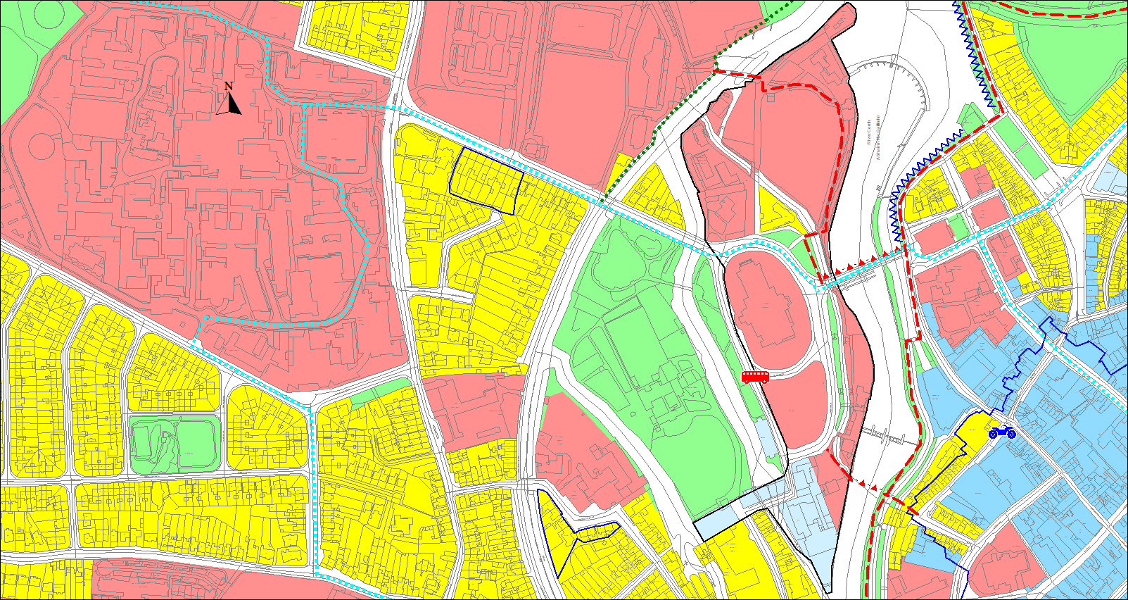
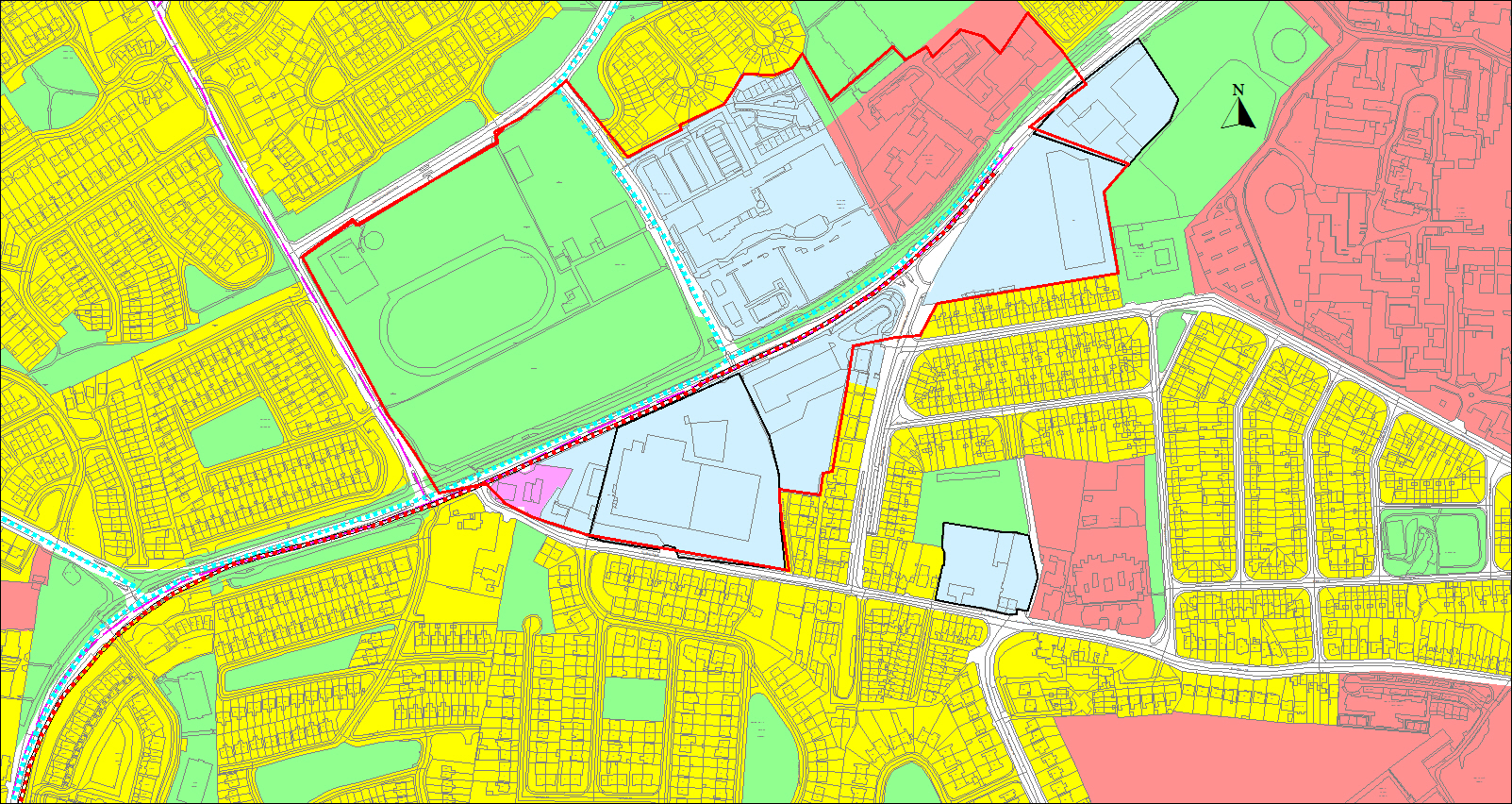
10.7 Headford Road Regeneration Sites
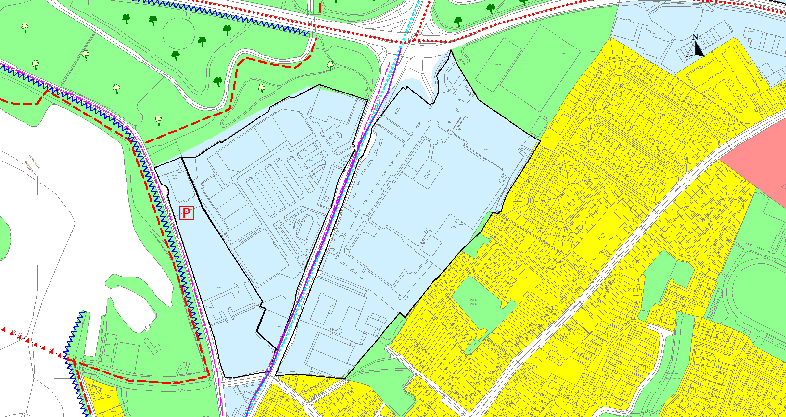
Figure 10.4 Headford Road Regeneration Sites
The Headford Road area located south of the Bodkin junction and the N6 and adjoining the River Corrib is a busy commercial area adjacent to the city centre incorporating the three Regeneration Sites namely the Dyke Road car park site, Galway Retail Park and Galway Shopping Centre. There are significant natural heritage and amenity assets within the area with the River Corrib, Terryland Forest City Park, Bohermore Neighbourhood Park and the Plots Local Park.
These regeneration sites located adjacent to the city centre provide opportunities for redevelopment of significant scale. The regeneration of these lands is an identified Growth Enabler in the NPF. They have considerable advantages given their proximity to the city centre, the existing infrastructure available and the extent of natural heritage and amenity resources. Their regeneration offers a sustainable expansion of the city centre, linked in to the public transport and pedestrian network and has capacity to reinforce the prime role of the city centre in both Galway City and the MASP area and has potential to consolidate and enhance Galway’s position as a leading regional city. There is also an opportunity to support city centre living, with a new residential community.
Currently the overall area has a weak urban structure and lacks cohesion. The existing commercial area comprises low grade buildings and the existing floorspace is well below sustainable density standards. The existing parks lack adequate passive surveillance and could be better utilised for public benefit. The upgrade of the Bodkin junction to a signalised junction and the revision of access and traffic circulation measures have made improvements to traffic flow and pedestrian and cycle linkage. Despite this the area still suffers traffic congestion, particularly at peak times and would benefit from improved linkages and connections. The area extends to approximately 30 hectares and its redevelopment is best realised within the structure of a LAP. This approach will result in a sustainable integrated development framework for the area supporting the creation of a vibrant mixed-use area including for a commercial and residential district with cultural, civic and amenity facilities.
A planned redevelopment will enable the most integrated and efficient use of the land and will deliver maximum transformative benefits.
Taking an integrated planned approach to the redevelopment of this area will also give greater certainty through active land management and phasing.
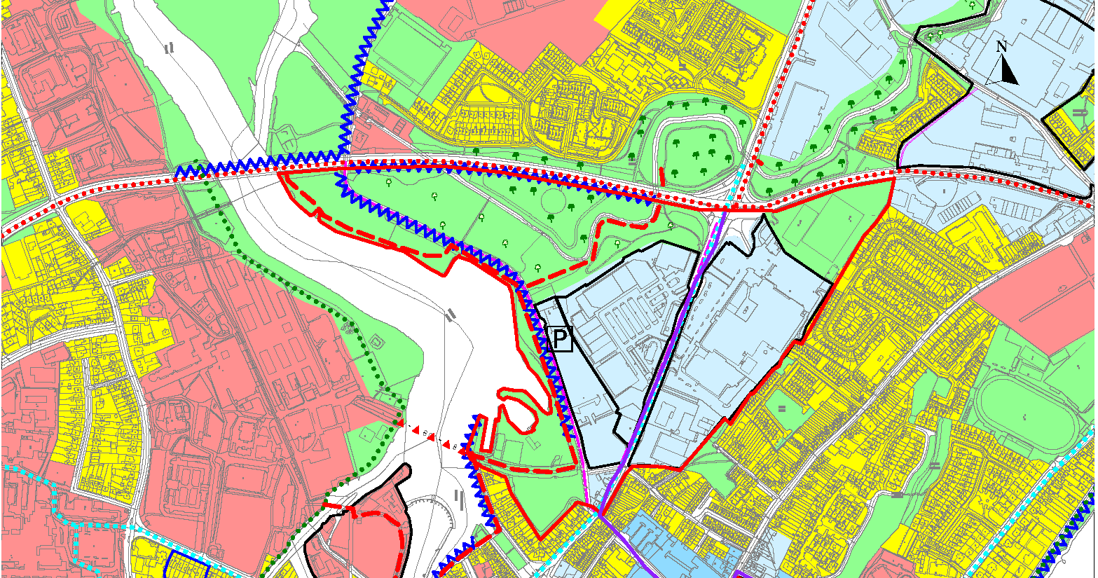
Figure 10.5 Headford Road LAP area (outlined in red)
The preparation of the LAP will build on a previous draft framework for these lands which considered the principal aspects of placemaking, planning, sustainable transportation, architecture, engineering, landscape design, ecology, access, passive surveillance and development economics. It is intended that the LAP will encourage a diversity of uses to sustain an animated and vibrant public realm of streets and urban spaces promoting sustainable transportation options. It will seek to maximise the opportunities that exist to integrate and protect the natural heritage assets of the area, create improvements to the existing parks and provide high quality linkages to the city centre, NUI Galway and outer residential areas. The Plan will reflect the unique character and culture of Galway and acknowledge the dynamism of this urban area. This is an area identified at risk of flooding by virtue of its location along the River Corrib and defended by the Dyke road embankment and specific flood risk assessment of the lands was undertaken in 2012. The LAP will be required to review this assessment and comply with any requirements of the Coirib go Cósta Galway City Flood Relief Scheme. The LAP will also include for extensive public consultation.
Dyke Road Car Park Regeneration Site
This City Council owned site measures approximately 1.79 hectares. It is a Land Development Agency (LDA) national priority site for delivery of housing and other uses in collaboration with the City Council. The site has the advantage of scale, at a location close to the banks of the River Corrib and Terryland Forest Park with potential to exploit good open aspect of the River. The site is currently occupied by the Black Box Theatre, an adaptive, multipurpose, performance space, and an extensive surface car park that supports the theatre, the adjacent retailing and provides commuter car parking.
The redevelopment of this site by the LDA has potential to transform this area and be a catalyst for regeneration of the wider Headford Road area. Investment at this location can create a driving force for further similarly scaled projects on the adjacent regeneration sites. The scale of the development could transform the character of this greater area, reversing the current sterile environment to one of a livable urban quarter.
As an LDA project, the residential element of development will include for affordable housing options. Other uses may include office/commercial use as well as provision of civic, cultural and arts infrastructure. There is potential to explore innovation and research uses allied to NUI Galway with enhanced linkage to the university made possible with the proposed new pedestrian and cycle bridge. Any development will be required to be an exemplar in architecture, urban design and placemaking and deliver a high-quality public realm linked to the wider green network.
In the event that opportunities arise to progress development proposals to planning consent stage in advance of the adoption of a LAP, these proposals will include for a Masterplan which will take cognisance of the integrated development strategy included for in the framework plan for this area. The Masterplan will be required to have regard to guidance set out in Chapter 8. Flood risk assessment of the lands was undertaken including detailed modelling and identification of possible flood mitigation measures in 2012 and will be required to be reviewed in the context of the Coirib go Cósta Galway City Flood Relief Scheme.
Headford Road Regeneration Site - Galway Retail Park
This Headford Road Retail Park occupies a site of approximately 4.3 hectares. The Retail Park dates to the early nineties and is occupied by a range of retail and commercial uses accommodated in a warehouse style, low density car based layout. Regeneration of this site has capacity for a significant intensification and greater height that can create a strong edge along Headford Road and Terryland Forest City Park, incorporating high quality urban design and architecture with a diverse and balanced mix of uses to sustain an animated and vibrant public realm of streets and urban spaces. The regeneration of this area will provide for enhanced sustainable mobility within the city reducing the reliance on the private car. It has potential to make a transformative difference, creating a better urban form, bringing new life and footfall to the area and increasing housing supply close to the city centre. It can also support GTS measures providing easy access to public transport and active travel networks including the proposed new bridge link to NUI Galway and greater connectivity to the green network.
A number of developments have been granted on this site, the most recent being a seven storey student accommodation building with commercial use at ground level. The preparation of an LAP will give detailed guidance for future development and will continue to support a minimum 30% residential content on the overall site.
Headford Regeneration Site – Galway Shopping Centre
This Headford Road shopping centre occupies a site of 6.8 hectares. The shopping centre dates to 1972 and is occupied by a range of retail uses and experiences significant footfall. It is reflective of its era developed as a single storey introverted mall linked to car borne patronage. It represents a development form which requires modernisation with the layout and organisation of uses on the site representing an inefficient use of urban land.
Similar to the retail park, the site has significant potential for intensification, a better urban mix, an improved pedestrian environment and permeability. Subject to a LAP, the redevelopment of this site to a significant scale has potential to create a new vibrant urban quarter with increased retail floorspace, commercial space and cultural and civic uses and a new residential community with a minimum 30% residential content required.
Key to the success of these regeneration areas will be the enhancement of links to the city core, in particular along Headford Road, Bóthar na mBan and Woodquay. These streets require investment to improve public realm and rebalance the priority for pedestrian and cyclist movement to make them attractive, safe and convenient.
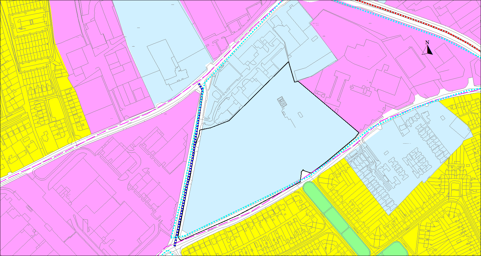
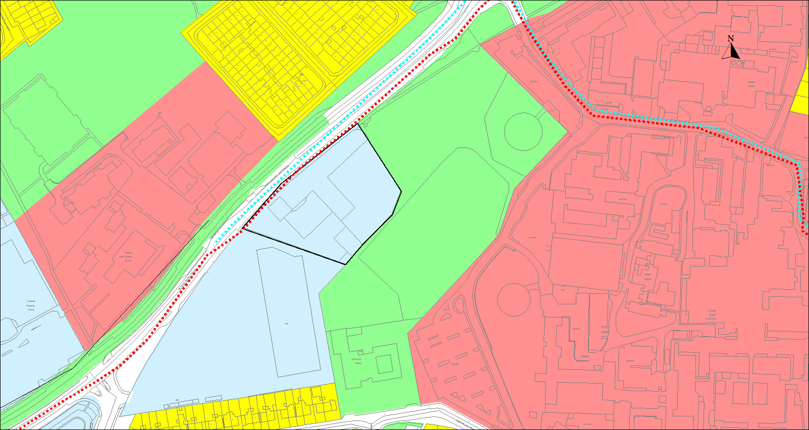
10.8 Sandy Road Regeneration Site
The Sandy Road Regeneration site is an assemblage of three parcels of land comprising approximately 8 hectares. The significant scale of the site and its location approximately 1.2km from the city centre some 15 minutes walking distance merits consideration for a significant level of redevelopment. The site is a Land Development Agency (LDA) national priority site for delivery of housing to include for affordable options with some commercial use.
The site comprises underutilised local authority lands supporting City and County Council depots, recycling facilities and small basic commercial enterprise units. The other portions of land are occupied by low density ESB Networks office and work depot, local radio station and former primary school. The site also includes recreational and amenity zoned lands which form part of Terryland City Park. The site commands extensive street frontage along Sandy Road and Sean Mulvoy Road and to a lesser extent onto the Tuam Road but has poor address, lacks permeability, has low footfall and a characterless form. It is flanked by the Liosbán Industrial Estate, Gort na Glaise and Gleann na Trá housing developments. The ambition for regeneration of the site is to deliver a new urban quarter with attractive living space including vibrant pedestrian friendly streets and public space of scale. This would bring about physical, social and economic transformation, to make the area a successful place with a distinct identity in a Galway context. The potential for such dramatic change is enabled by the location within easy reach of the city centre, Terryland City Park and employment opportunities. The site has scope to accommodate high density, quality architecture, a more fine grained urban morphology and an element of commercial workspaces.
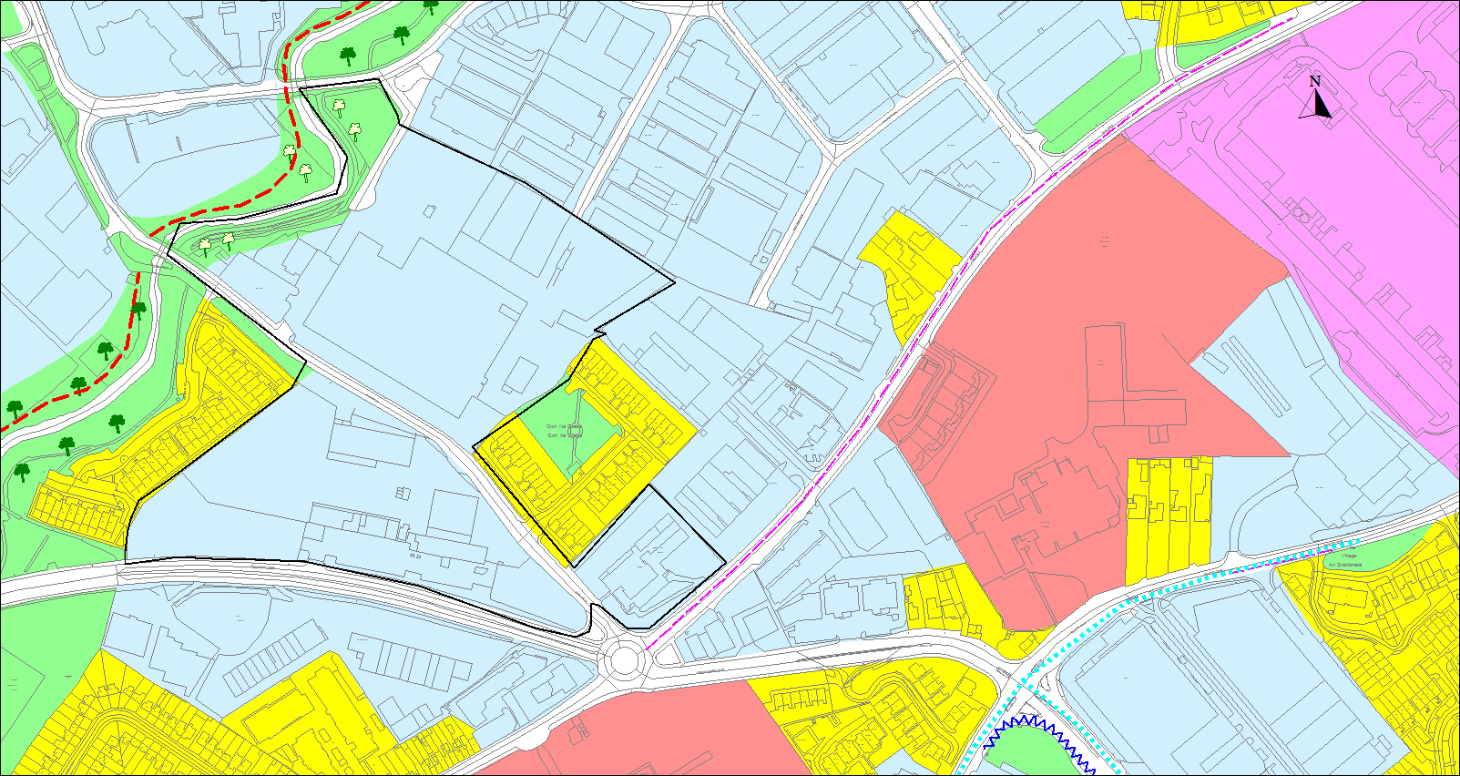
Figure 10.6 Sandy Road Regeneration Site
The site is well serviced by all utilities and is within easy access of a wide range of services, located close to core bus routes and a well-integrated pedestrian and road network. Part of the site is identified as at risk of flooding associated with the Terryland/Sandy River and will require a specific flood risk assessment which will be required to have regard to the Coirib go Cósta Galway City Flood Relief Scheme project. In this particular case, having regard to the locational assets, national policy context, and the regeneration status of the site, the majority of the site can be dedicated to a residentially led development.
The City Council intend that the development of this regeneration site will not be an end in itself, in that it should also be a catalyst for change in the adjoining Liosbán area and encourage a more integrated area, better urban structure and layout more conducive to good quality and sustainable patterns of movement.
As part of the initial consideration of design options for the site, the LDA and City Council in conjunction with the RIAI in 2019 prepared the “Sandy Road Design Review” to explore options for redevelopment of this brownfield site. A more detailed masterplan/spatial framework will be required to examine the constraints and opportunities of the site, taking into consideration the physical, social, environmental aspects.
The relocation of the existing uses, in particular the operations of the local authorities, will be required to be undertaken in parallel with any master plan/spatial framework.
In additional to the general urban design requirements set out in Chapter 8 the following will be required to be included in a masterplan/spatial framework:
- Examine the vision and potential for redevelopment based on evidence based analysis.
- Examine preferred options for redevelopment which would include for sustainable densities, a significant level and mix of housing, suitable enterprise uses and other appropriate and complementary uses including public space.
- Activate the frontage of the development site and provide high quality public realm space that will connect and lever off the existing Terryland/Sandy River and adjoining recreation and amenity lands and linkages.
- Include for public realm that is designed in a manner that maximises the benefits of the location adjacent to Terryland City Park that achieves a strong sense of place and achieves permeability.
- Maximise potential for synergies with planned public investment in sustainable modes identified in the GTS and sustainable and active travel and requirements for multi model parking facilities.
- Include for sufficient infrastructure and a layout that provides connections to adjoining areas, and enhanced connectivity.
- Demonstrate how layouts contribute to aspects of urban design such as accessibility, enclosure, character, permeability and adaptability. Consider opportunities for innovative architecture or architecture by design competitions.
10.9 Nun’s Island Masterplan Area
Figure 10. 7 Nun’s Island Masterplan Area
Nun’s Island is located to the west of the city centre and is characterised by a strong architectural heritage and by a number of natural and man-made waterways. It was an important location for industry, particularly in the nineteenth century and included the sites of the county and town jails, which are now occupied by the Galway Cathedral and adjacent car park.
The Nun’s Island area offers opportunities for regeneration, in particular of existing NUI Galway buildings, new and improved public spaces and improved access and linkage to the River Corrib and canal system.
The regeneration of this area presents an opportunity to enhance and transform a historic neighbourhood, support reuse and adaption of historic buildings to achieve better integration with the surrounding city and connections with valuable waterways. URDF funding has been awarded to NUI Galway to support delivery of a Galway Innovative and Creative District at this location.
Development on these lands will require a Masterplan which shall be prepared in accordance with guidance set out in Chapter 8.
In addition, the following will be required to be considered:
- Examine a range of uses which would be appropriate for this area supporting enterprise, innovation, education, tourism and community.
- Investigate the potential to optimise the use of NUI Galway properties including the vacant former Hygeia building and former mill building, with application of best conservation practice.
- Include measures to enhance amenity and open space, consider sustainable recreation opportunities and include for increased public access to the waterways. It will also be required to demonstrate a sensitive approach to the high quality waterways environment.
- Consider the existing character and context of the area and demonstrate how redevelopment will contribute to aspects of urban design.
- Demonstrate how the development will protect the community and natural value of the waterways through ensuring development retains a sufficient set back and buffer from this sensitive environment and that any development is of an appropriate scale and design to address this unique setting.
- Consider the impact on views and vistas both into and out from the area and consider the assimilative capacity of the existing built environment and streetscape.
- Include for an open space typology and consider the potential for creation of a new urban space and public realm.
- Include a movement strategy and integration with the existing campus and the city centre.
- Include for community engagement in the preparation of the plan and an audit of benefits for the local community.
- Carry out detailed flood risk assessment and demonstrate that any redevelopment is resilient to the impacts of climate change. There will also be a requirement to comply with the outcomes of the Coirib go Cósta Galway City Flood Relief Scheme being advanced by the City Council in conjunction with the OPW.
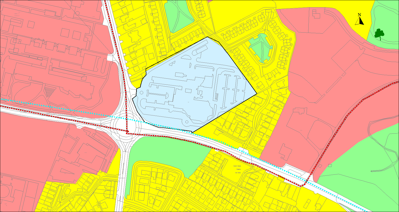
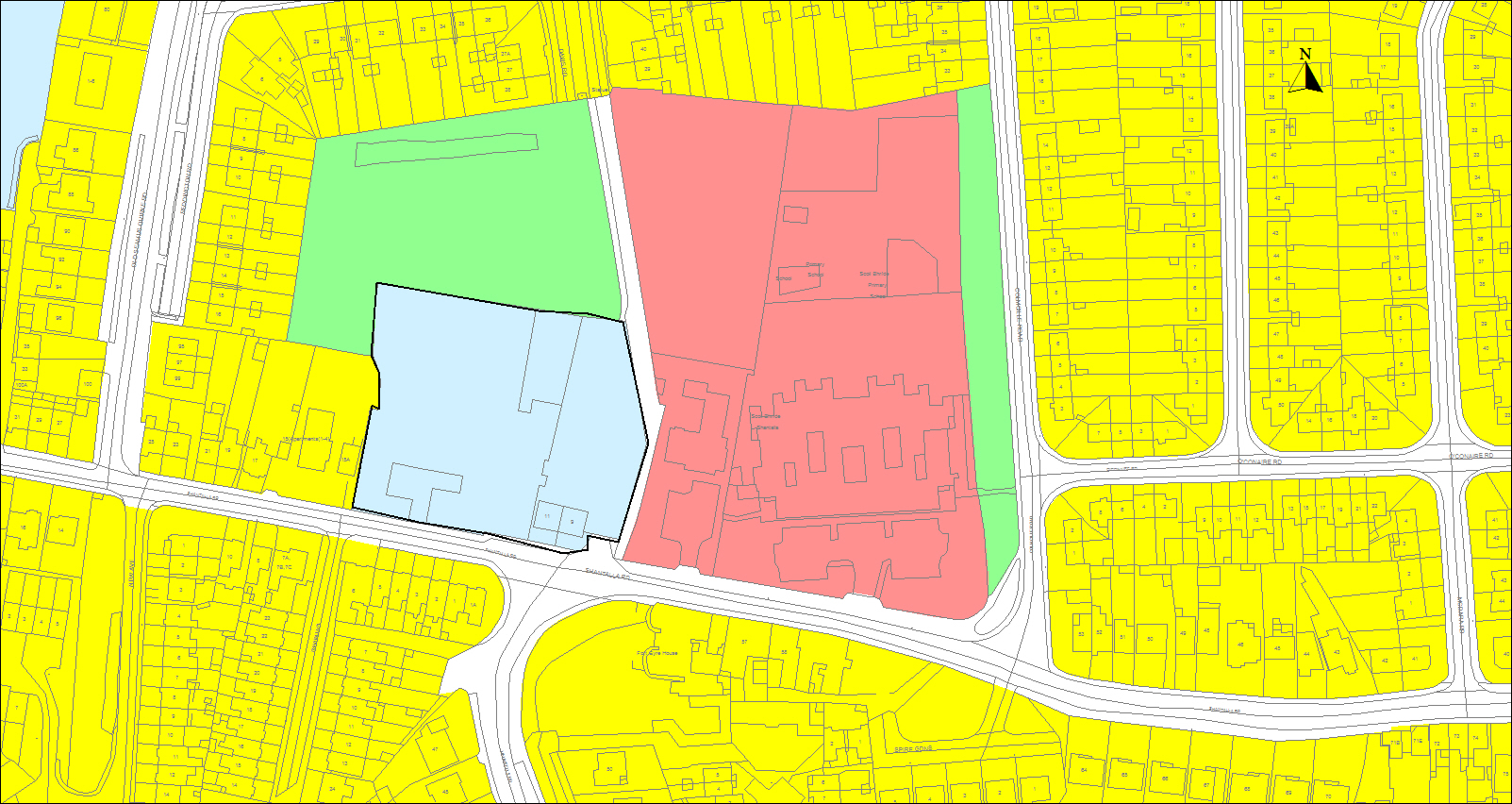
10.10 Seamus Quirke Road Regeneration Site
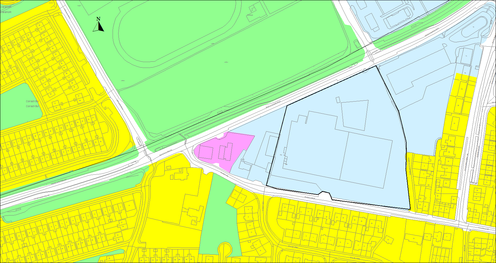
Figure 10.8 Seamus Quirke Road Regeneration Site
This site measures 3.88 hectares and is located within the designated Westside District Centre. This site has capacity for a mix of uses which could include for uses such as primary healthcare, commercial and office uses.
The site will be required to accommodate residential use in view of the advantaged location, being proximate to key facilities, along a public transport corridor and adjacent to park facilities.
In general, redevelopment of the site shall have regard to section 10.2 and Policy 10.2. Given the significant scale of the site, an overall Masterplan will be prepared in advance of any redevelopment which shall adhere to the guidance in Chapter 8. The Masterplan will also be required to include measures to support the designation of the wider area as a pilot decarbonisation zone.
10.11 Crown Square Regeneration Site
This 5.1 hectare site is located on the Monivea Road at a key junction with Joyces Road. Part of the site which comprises phase 1 is currently under construction accommodating an office campus development and hotel. The balance of the site has consent for a high density Build to Rent residential scheme and ancillary local services. This site had the benefit of a Masterplan and any future change in development proposals will be required to adhere with the original Masterplan principles.
Figure 10.9 Crown Square Regeneration Site
10.12 Corrib Great Southern Regeneration Site
This 2.7 hectare site is located on the Dublin Road at the Skerrit Roundabout. The site formerly accommodated a hotel and surface car park. It has potential for significant redevelopment for a mix of uses and in particular for residential use to meet the housing targets for the city.
Figure 10.10 Corrib Great Southern Regeneration Site
A minimum of 50% of the potential gross floor area shall be reserved for residential use. In view of the advantaged location, being proximate to key facilities, a location along a public transport corridor and with good aspect, a greater proportion of the floor area space can be dedicated for residential purposes where the site supports a range of neighbourhood facilities, community facilities for the wider area, and an open space of a scale and quality to function as a local park.
Given the significant scale of the site and obligation to deliver certain uses, a Masterplan will be required in advance of any redevelopment. In addition to guidance set out in Chapter 8, the Plan will incorporate the proposed BusConnects Galway: Dublin Road pedestrian, cycle and public transport corridor and a setback equivalent to the existing green linear space running along the Dublin Road.
10.13 Former Dawn Dairies Opportunity Site
Figure 10.11 Former Dawn Dairies Opportunity Site
This 1.38 hectare site located along the Dublin Road at the junction with the Ballyloughane Road is the site of the former Dawn Dairies. This site has potential for redevelopment for high density housing. This development should include for a development of high architectural design quality, strong street frontage which may include for accommodation of small scale local services.
Given the scale of the site any proposed development should include for a spatial framework.
10.14 Royal Tara China Opportunity Site
Figure 10.12 Royal Tara China Opportunity Site
This 1.9ha site located on Connolly Avenue is the original residence of the Joyce family and was subsequently the Royal Tara China Facility and its industrial zoning reflects this use. The building is a protected structure located within an attractive sylvan setting. The site has potential for sensitive redevelopment as part of the overall conservation and enhancement of the protected structure and its curtilage. The preference is for the protected structure to remain in single use to retain the integrity of the structure. Given the scale of the site any proposed development should include for a spatial framework which will consider the optimum use of the site and will be required to ensure protection and enhancement of the protected structure, curtilage and protection of valuable tree species.
10.15 Arch Motors Opportunity Site
Figure 10.13 Arch Motors Opportunity Site
This site of 0.84 hectare is located along the Seamus Quirke Road adjacent to the Westside district centre. It has capacity for redevelopment for a residentially led mixed use scheme, in view of the advantaged location, being proximate to key facilities, along a public transport corridor and adjacent to park facilities.
Any redevelopment should include for a spatial framework which will be required to include for measures to support the designation of the wider area as a pilot decarbonisation zone
10.16 Shantalla Road Opportunity Site
Figure 10.14 Shantalla Road Opportunity Site
This site of 0.62 hectares is located along the Shantalla Road. This site has capacity for redevelopment primarily for residential use to assimilate into the existing neighbourhood. The density of any redevelopment shall have regard to the surrounding context.
Any redevelopment shall provide for a high quality frontage onto the Shantalla Road and the open space area to the rear providing passive surveillance to this area. It shall also provide for the enhancement of Red Lane, the link route adjacent to the eastern boundary. Any redevelopment should include for a spatial framework which will be required to include for measures to support the designation of the wider area as a pilot decarbonisation zone.
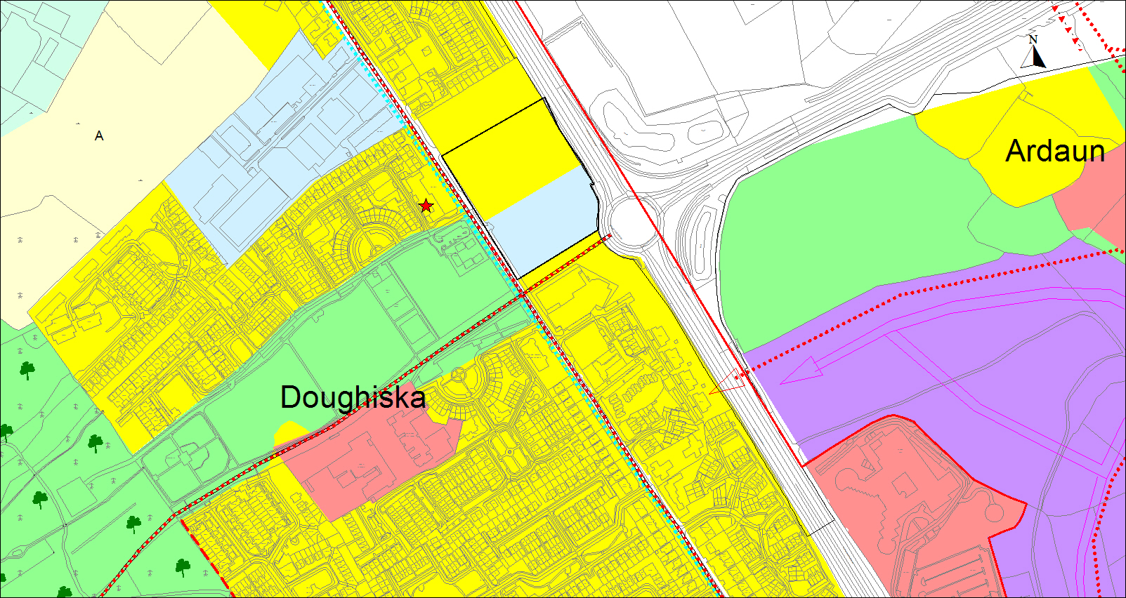
10.17 Doughiska Road Opportunity Site
Figure 10.15 Doughiska Road Opportunity Site
This 2.58 hectare site is located between the Doughiska Road and the dual carriageway with access onto the Doughiska Road. This site has potential for significant development for a mix of uses including for residential use. The development of this site can enhance the level of services in the Doughiska area and provide for additional housing choice. Planning permission has been granted on this site for a significant scale of commercial development and 130 residential units. Subject to good urban design, the site can accommodate development of scale providing a strong edge to both roads. The potential for height and density is reflected in the grant of planning permission on this site.
Any new proposed development on this site will require a spatial framework to be prepared. In addition to the general guidance set out in Chapter 8, the framework will also take account of the archaeological context of the site and shall also integrate with the adjoining reservation for a pedestrian/cycleway.
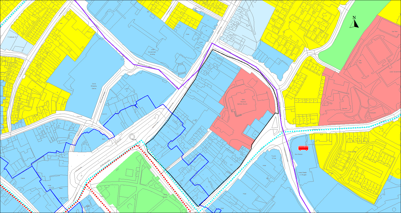
10.18 Eyre Square East Regeneration Site
Figure 10.16 Eyre Square East Regeneration Site
This regeneration site comprises a significant block of properties assembled for the purposes of redevelopment. This site is of considerable scale made up of a range of buildings and uses in a prime city centre location and partially within the Eyre Square ACA.
A Masterplan will be required to inform any redevelopment guided by the principles set out in Chapter 8. It will be required to consider the particular sensitivities of this site location within the historic core including the context of Eyre Square ACA and structures on the RPS.
The Masterplan will be required to demonstrate the merits of the development strategy being pursued and show how it would result in the creation of a successful new quarter in the city. It is recognised that this does not infer nor necessitate the replacement of many existing structures within the block nor alter the form of the existing surrounding principal streetscapes within the block, rather it would show how new development could complement and enhance the overall block.
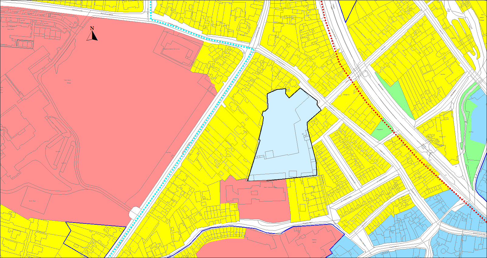
10.19 Former Connaught Laundry Opportunity Site
Figure 10.17 Former Connaught Laundry Opportunity Site
This 0.87 hectare site is located on Henry Street, an area which has a distinctive character and a strong residential community. This site has capacity for redevelopment primarily for residential use to assimilate into the existing neighbourhood. The density of any redevelopment shall have regard to the surrounding context.
In this regard, the Council will consider residential development on the full extent of the site alongside appropriate public realm and community facilities. Any proposed development should include for a spatial framework.
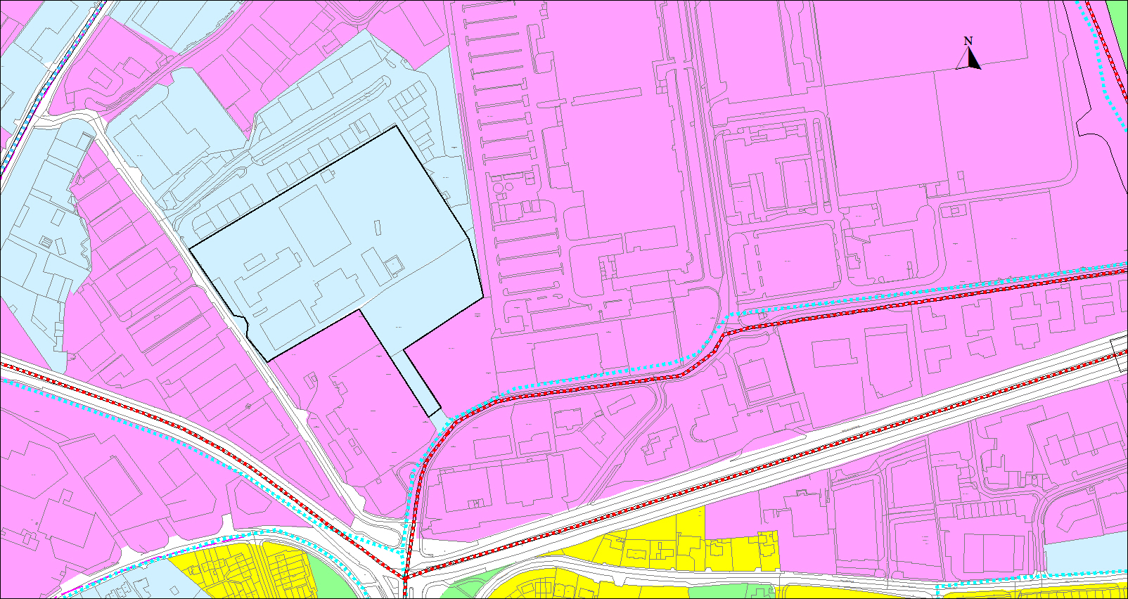
10.20 Eastgate Regeneration Site
Figure 10.18 Eastgate Regeneration Site
This 4 hectare site is located along Bóthar na Mine and is currently occupied by a hardware store and garden centre. The site has significant capacity to support commercial redevelopment of scale being proximate to the Ballybrit Business Park and proposed BusConnects route. The site already has benefit of planning consent for significantly scaled office accommodation. Such redevelopment will enhance the level of commercial office provision in the city and support wider city and regional economic growth.
10.21 Knocknacarra District Centre (North) Opportunity Site
Figure 10.19 Knocknacarra District (North) Opportunity Site
This site measures approximately 4 hectares and is located in the designated Knocknacarra District Centre. The wider district centre lands already accommodate significant development including the Gateway Retail Park, office space and Gaelscoil Mhic Amhlaigh primary school. This area provides a range of convenience and comparison multiples. This site is the last remaining undeveloped parcel in the northern section of the District Centre.
A key element of the overall vision for the Knocknacarra District Centre is that it functions as an ‘urban village’ type centre rather than purely a shopping area. This was supported through specific development objectives for the district centre lands in the 2017-2023 plan, which required a mix of uses including service retail, public health facilities, community, recreational and residential uses, to achieve vibrancy and distinctiveness and local identity. In particular the requirement to provide for a 20% residential content has not been delivered to date and will be required to be fulfilled on this site in addition to the provision of a high quality public realm which will accommodate a civic space as a focus for community activity and amenity.
Any proposed development should include for a spatial framework having regard to guidance set out in Chapter 8 and will be required to consider the following:
- Development will be integrated within the overall district centre and proposals will be required to demonstrate linkage with the wider neighbourhood area, the transport, pedestrian and cycle networks and linkage to the green network.
- Any development shall include for a high quality urban design.
- Any design shall integrate the realigned link road of the N6 GCRR.
10.22 Knocknacarra District Centre (South) Opportunity Site
Figure 10.20 Knocknacarra District Centre (South) Opportunity Site
This site measures 6.6 hectares and is located within the designated Knocknacarra District Centre. A key element of the overall vision for the Knocknacarra District Centre is that it functions as a mixed use urban village creating an attractive, liveable, well designed urban centre integrated into the community where placemaking and sustainable mobility is prioritised and where the idea of the neighbourhood concept is strengthened. Having regard to the population growth targets for the city and reflecting the core strategy, a significant proportion of the development capacity of the site shall deliver housing.
Given the significant scale of the site and obligation to deliver certain uses, a Masterplan will be prepared in advance of any redevelopment. The following requirements will apply over and above the guidance provided in Chapter 8:
- Include for a minimum of residential/residential commercial development of a scale equivalent to 50% of the development capacity of the site which shall be integrated into the overall scheme.
- Provide mixed uses which shall include for a number of small retail /service retail units which can be demonstrated to deliver a broad range of District Centre uses. This shall be assessed in the light of the scale and nature of uses delivered on the site at that period.
- Provide a good balance of use mixes, including uses which can include healthcare and primary health care, commercial leisure uses, hotel and educational uses, which would by virtue of their use and scale serve the needs of the surrounding neigbourhood area.
- Provide a strong frontage and address of the Western Distributor Road and internal street network with the avoidance of dead frontages.
- Provide quality pedestrian and cycle connections with the adjacent neighbourhood, schools, open space lands and wider green network.
- Demonstrate a structured hierarchy of spaces within the layout maximizing the opportunities for linkage with adjacent developments/future developments.
- Ensure pedestrian priority in the access network and accommodate public transport access or easy access to the public transport network and incorporating emerging bus route proposals along the Western Distributor Road.
- Demonstrate divisible viable phases of development.
- Having regard to investment in public transport and sustainable mobility measures, the level of car parking provision will be considered having regard to performance based standards, urban design, sustainability, location and scale of development proposed and should reflect the designated location being a multi-purpose trip destination.
- The site shall include for a civic open space/park which shall be reserved on any layout for this purpose and should be of a size and function to reflect the scale of the overall development and shall be over and above the requirement for open space on these lands.
- Each phase of the development shall include for the front loaded delivery of a public /community facility which can be in the form of a community facility, an educational establishment, a community health facility, a transport facility, a park and play area over and above normal open space requirements.
|
Policy 10.2 Strategic Regeneration and Opportunity Sites |
|
Facilitate and enable the redevelopment of strategic Regeneration and Opportunity Sites in the city to support the sustainable and compact growth of the city which will add value and create more attractive places in which people can live and work and achieve alignment with the National Strategic Outcomes of the NPF and the Regional Policy Objectives of the RSES and implementation of the Core Strategy. |
10.23 Salthill
Salthill has changed over time but it still retains its distinctive character and amenity value. In recent years it has re-established itself as an urban village with many of the former hotels and nightclubs replaced by apartments, cafes and restaurants. This has led to an increase in the permanent residential population supporting a broader range of local services for the local community, visitors and an expanded catchment area. The significant attractions of the area are the seafront, promenade and extensive beach facilities. These assets ensure that it retains many of the traditional seaside resort characteristics and uses such as entertainment facilities, cafés, restaurants and a range of tourist accommodation and attractions. Other attractions including indoor swimming and leisure facilities at Leisureland and the Aquarium contribute to the diversity of uses, giving Salthill a distinctive character and vibrancy.
Figure 10.21 Salthill
The Salthill Promenade is a major recreational facility for city residents, linking the existing walkways from the city centre, South Park, Mutton Island causeway to the Blackrock walkway. It is also a strong tourist attraction and key city landmark culminating with the iconic Blackrock diving tower. It is an important active and passive amenity space with significant footfalls particularly during the summer season. Salthill has both natural and built heritage assets. It has secured Blue Flag status for a succession of years, which is a significant asset in promoting a clean image of the city and in developing water based recreation and amenity activities. Of late, it has experienced an increase in year round sea swimming which adds increased vibrancy and value to the area. Toft Park, Celia Griffin Park, Salthill Park and the Circle of Life Park also contribute greatly to important elements of the green network in Salthill. Along the promenade the shelters, seating areas, kiosks and diving tower are unique and hallmark features of social, architectural and technical interest and contribute to the resort character of the area. Proposed enhancements to the diving tower area and the feasibility of redevelopment of the tidal pools have potential to add to the character and atmosphere of the area.
Salthill remains an area in transition and requires special attention to safeguard and strengthen its identity and role as an urban village. Issues such as underutilised sites and lack of design consistency along the main commercial spine need to be addressed. The area lacks good pedestrian permeability, with vehicular traffic and parking dominating the main commercial street and poor connectivity between the commercial area and the promenade.
The Council will seek to strengthen Salthill as an urban village and as a recreation and coastal amenity area by encouraging high quality mixed-use development and by carrying out improvements to the public realm. This will be achieved by ensuring good standards of design of infill and redevelopment, a mix of uses, improved accessibility and more disciplined shop front and signage guidance in accordance with those promoted for Salthill in the Galway Shop Front and Signage Guidelines. The Council will also discourage the spread of uses, which would lead to the deterioration in the attractiveness and amenity value of the area.
In order to reflect the urban village status and streetscape of Salthill, and having regard to planned investment in public transport and sustainable mobility measures, the level of car parking provision will be considered on performance based standards, urban design, sustainability, location and scale of development proposed.
Leisureland is a significant public asset and in combination with the adjacent site which is also in public ownership, there is considerable potential for redevelopment of scale. In this regard the Council will progress proposals for the expansion and improvement of Leisureland with the potential to provide for modern, purpose built recreation, civic and cultural facilities to serve the city and region.
To further strengthen the role of Salthill, the Council will undertake an environmental improvement scheme in consultation with local businesses, residents and other stakeholders, which will identify areas which would benefit from public realm improvements. These will be so designed to improve the visual amenity, calm traffic and improve sustainable linkages between the promenade and the commercial area. Specifically under review will be the need for greater pedestrian priority, traffic management and car parking rationalisation along the main commercial spine on Upper Salthill Road and examination of extending the capacity for outdoor dining.
The vicinity of Seapoint and the D’Arcy Roundabout will be examined as an area which could merit improvements together with measures to improve pedestrian connectivity to the promenade and other amenities, provision of high quality paving, landscaping and street furniture. The Council will also seek to improve linkages and accessibility to Salthill from the surrounding areas in particular from the city centre through implementation of measures proposed in the GTS in particular through improvements in public transport, walking and the cycling network. Proposed measures include the provision of a core bus route through Salthill and improvements in the cycle and pedestrian network.
In recognition of the importance of the Salthill promenade as a recreation and amenity resource and a tourist attraction, the Council will carry out a strategy for its long-term management and enhancement. The strategy will consider issues such as access, car parking, support facilities, surface treatment, landscaping and street furniture and supporting infrastructure for water based activities. It will build on improvements carried out following the storm damage in recent years. It will also complement the rehabilitation works proposed for the Blackrock diving tower and works to enhance accessibility for users of these facilities. In particular, it will consider the impacts of climate change and measures to ensure that this area is resilient to the challenges of extreme weather events. The strategy will be required to comply with the outcomes of the Coirib go Cósta Galway City Flood Relief Scheme being advanced by the City Council in conjunction with the OPW.
|
Policy 10.3 Salthill |
|
|
|
|
10.24 Westside
Figure 10.22 Westside
Westside is an important service centre located in the established suburbs. In the retail hierarchy, it is designated as a district centre. It has a wide range of community and commercial facilities and services and is a well-established neighbourhood with a strong community. Developments including the Seamus Quirke Road Improvement Scheme, Westside Amenity Park, Corrib Park and Shantalla Park improvements have enhanced the urban environment, however the area has a weak urban structure and poor physical cohesion. It lacks a strong urban definition and streetscape which means it has a poor legibility and sense of place.
The objective for Westside is to improve connectivity, to increase attractiveness and encourage more sustainable street level community interaction and activity. This could be achieved through the re-development of identified Regeneration and Opportunity Sites, improved permeability, reduction of the ”barrier effect” of the Seamus Quirke Road and requirements that re-development include for more enclosure, good use mix, use of scale and massing to create more human scaled address to public areas and in general a better urban design regime. This coupled with more public realm improvements will complement works carried out to date and contribute to a more animated, vibrant streetscape. Its location within a pilot decarbonisation zone has potential for measures to support a low carbon footprint in this area and could include for example, opportunities for district heating or combined heat and power initiatives.
|
Policy 10.4 Westside |
|
Enhance the quality of the urban environment at Westside through the creation of a more enclosed, strong street edge on CI zoned lands along the Seamus Quirke Road, creating a high quality active and vibrant streetscape. |
10.25 Ardaun LAP
A key element of the settlement strategy for the city is the development of Ardaun to the east of the city. This is reflected in the Core Strategy with significant future population and residential growth planned for this area. In recognition of its strategic potential, it is identified as a key city growth enabler under the NPF and a Strategic Growth Area in the RSES and MASP. It is also designated by central government as a Major Urban Housing Delivery Site (MUHDS) capable of significant housing delivery.
This area measuring c164 hectares will provide opportunities for high density residential development structured and co-ordinated with other essential community services. It is well placed to develop good employment opportunities having close physical links with the existing technology parks at Mervue, Ballybrit / Parkmore and strategic IDA sites at Oranmore and Athenry. It is also well placed to link in with and take advantage of the proximity of higher level institutes at GMIT and NUI Galway and the significant health institutions at Merlin Park Hospital and the Galway Clinic. Ardaun is integrated with the transport strategy and capable of benefiting from planned investment in the BusConnects programme, active mode networks and commuter rail investment at Garraun.
The Ardaun Local Area Plan 2018-2024 was adopted on 9th April 2018. It aims to ensure that growth in Ardaun is focused around an attractive and accessible new urban village and residential neighbourhood that services the everyday needs of local people is designed to encourage sustainable transport modes, providing a variety of homes, community services, network of streets, quality green open spaces and public realm.
As set out in the LAP, Ardaun is capable of delivering up to 4,640 homes, accommodating a population of up to 12,621. The plan includes objectives for provision of two multi-campus (primary and secondary level) school sites and potential of 40,000sq.m. of commercial, office and leisure uses, and 18 hectares of recreation and amenity lands. The Ardaun area comprises two development phases. Phase 1 comprises the lands south of the M6/ N6 and a longer term phase 2 is the lands to the north of the M6/N6.
Through active land management, Galway City Council are working with stakeholders to support the delivery of development and supporting infrastructure, including Department of Housing, Local Government and Heritage, Irish Water, Department of Education and Skills, National Transport Authority and Galway County Council. To date significant funding has been received under the URDF to progress critical transport enabling infrastructure following on from the completion of an Area Based Transport Assessment (ABTA). This assessment determined the transport demand arising from the proposed land uses and the transport interventions required to facilitate this demand. It requires the upgrade of the Martin roundabout and associated link road to facilitate development of Phase 1, the southern section of Ardaun. It also recommends an additional new southern access to Ardaun from the R446. Work is expected to be completed in 2022 on the signalisation of the Martin junction and plans are advancing to upgrade the primary access to Phase 1 section which includes for bus priority, pedestrian and cyclist facilities. Design work is also being advanced to progress the additional southern access point. These works will facilitate public transport access into Ardaun and extension of the city pedestrian and cycle network into the lands.
With regard to water and waste water infrastructure, Irish Water are progressing improvements in infrastructural supports. In the short term, it is estimated that the existing network has capacity for an initial phase.
The development of Ardaun will be progressed, in the main, by the private sector using the development strategy established and will be supported by public infrastructure investment. The Council will take a proactive role in identifying all public funding opportunities to deliver necessary facilities and infrastructure. The new Urban Development Zone as provided for in Housing For All (2021) DHLGH may also be applicable to Ardaun supporting housing delivery and unlocking barriers to development.
|
Policy 10.5 Ardaun |
|
Develop Ardaun, in accordance with the Local Area Plan taking a co-ordinated and phased approach that will contribute to the integration of land use, urban form and structure, transportation and natural heritage to create a new urban village and a sustainable living and working environment. |
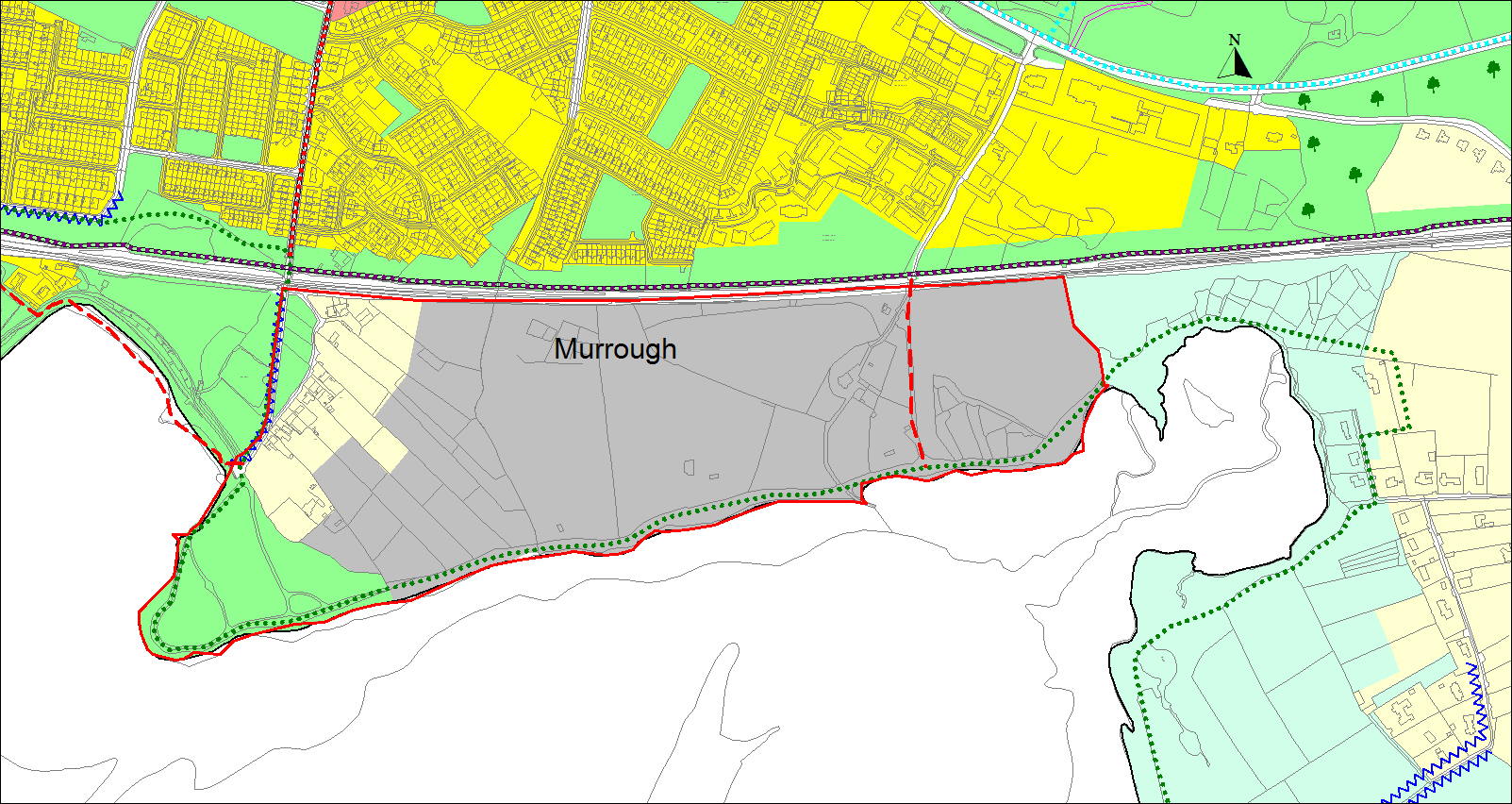
10.26 Murrough LAP
Figure 10.23 Murrough LAP
Murrough is an extensive area of semi-natural environment adjacent to developed areas east of the city, including Renmore, Ballybaan and Doughiska. The lands at Murrough have the distinction of being of substantial size (approximately 34 hectares) and located adjacent to the coastline, which is defined by a variety of features including beach and rocky shoreline. The area has direct pedestrian links to Ballyloughane Beach to the west and possibilities exist for coastal walks to Oranmore, to the east. The railway line and land reserved for a possible public transportation corridor forms the northern demarcation of the lands. There is also road and pedestrian access from Ballyloughane Road and Murrough Road. Given the rapid expansion of residential development in the east of the city and having regard to the future development of Ardaun, there is a demand for coastal and recreation facilities on the east side of the city. This demand is further increased by the current imbalance of coastal amenity/recreational facilities in the city with the bulk of these facilities, Salthill and Silverstrand being located on the west side of the city. The Murrough area offers potential for the provision of coastal and recreation facilities. These will complement the improved facilities at Ballyloughane Beach. Given the possibility of good public transport links, there is also the opportunity for mixed use development for a portion of the area. Mixed use development would contribute to the vitality of the area and provide a new residential neighbourhood. There is also potential for development, in particular sports and recreation facilities, allied to GMIT who are landowners in this area and the owners of Murrough House a protected structure.
In recognition of this, the Council will prepare a LAP for the Murrough area. The aim of the LAP is to ensure the reservation of a substantial bank of land for recreational purposes. The Plan will allow for mixed-use development, which will maximize the development of recreation facilities and will create a vibrant area with efficient public transport links to the rest of the city. It will integrate with the amenity facilities at Ballyloughane beach. The Plan will take account of the sensitive ecological environment at this location and will incorporate appropriate measures to mitigate against flood risk. In order to achieve the necessary recreational facilities, two thirds of the area will be reserved for this purpose.
Developments compatible with the G zoning which will not prejudice the aims of the LAP will be open to consideration in advance of the adoption of the LAP. In particular and in view of the significant interest of GMIT in lands at Murrough for the development of such uses, the Council will endeavour to work in partnership with the college to achieve a safe and suitable access to service the lands that will in turn facilitate their use for sports and ancillary facilities.
|
Policy 10.6 Murrough |
|
Develop the Murrough area in accordance with a Local Area Plan which will reserve a substantial bank of land for recreational purposes, allow for public access and allow for mixed-use development which will create a sustainable neighbourhood and maximise the sustainable development of appropriate recreation facilities. |
10.27 Specific Objectives
|
Specific Objectives |
|
City Centre Area |
|
|
|
Headford Road Area |
|
|
|
Regeneration and Opportunity sites |
|
|
Salthill |
|
|
|
|
|
Ardaun |
|
|
Murrough |
|
Contents
Observations
Observations
Area East of Galway Clinic
A chars,
I wish to voice my concerns regarding the development plan in the area concerning the east of the Galway Clinic. The area zoned urban village is adjacent to low density residential...
Salthill development
Salthill development: any development should recognise Salthill as being primarily a residential area. Any additional development should first and foremost be to the benefit of existing...
Chapter 10.6 Inner Harbour Regeneration Site:
The opening comments acknowledge that “constraints associated with the existing docks require that in order to modernise and address deficiencies, the harbour functions will need to be relocated to...